Introduction to CGI Montages
Computer-generated imagery (CGI) montage is a process used to seamlessly integrate digital 3D models into real-world settings, creating a realistic visualization of architectural projects before they are built. For developers, this technique offers a powerful way to showcase potential projects in their actual future locations, providing stakeholders with a clear vision of what a building will look like in its intended environment. AAI Drones, Visual Tricks, and CGI Finder recently collaborated to create a CGI montage for a new estate development, highlighting the benefits of this technology. This blog post explores how each company contributed to the project, with a detailed look at the CGI montage process and the role of drone photography.
Step-by-Step Guide to Creating a CGI Montage
1. Site Selection and Area Marking
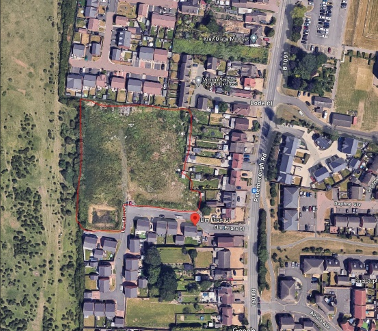
The first step involves identifying and marking the area of interest where the new building is likely to be constructed. In this case, the site is captured in the image labeled “Site,” showing the future location in relation to its surroundings. At this stage, the landscape and existing buildings are carefully reviewed to understand how the new development will fit within the local context. This is crucial for ensuring that the final CGI montage is both realistic and contextually accurate.
2. Utilizing Google Earth for Best Views and Shot Angles
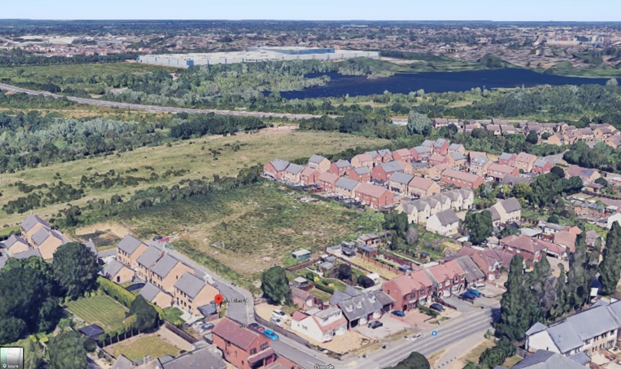
Google Earth plays a critical role in planning the CGI montage by offering a bird’s-eye view of the site, helping to determine the best areas and angles for photography. This approach allows the team to pre-visualize the layout and pick ideal shot angles that maximize the impact of the CGI integration. The aerial perspective from Google Earth (as seen in the image “Bird’s Eye Reference“) aids in planning for optimal drone shots that capture the site from every necessary angle.
3. 3D Model Creation in CAD
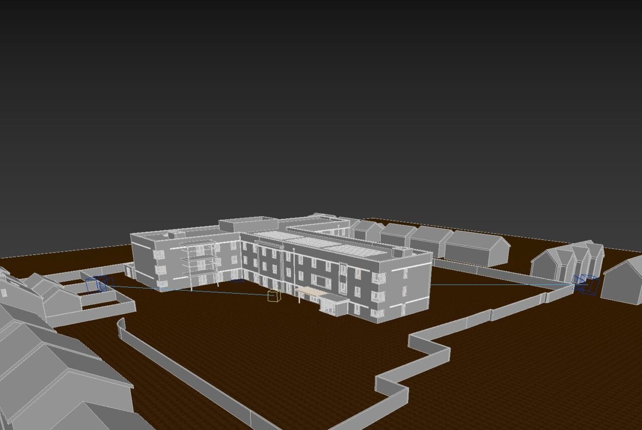
With the site and perspectives established, a detailed 3D model of the proposed building is created using CAD (Computer-Aided Design) software. This model, illustrated in the “3D Model” image, represents an accurate digital replica of the future building, complete with textures, materials, and architectural details. CAD modeling ensures that the CGI representation aligns precisely with real-world dimensions, enhancing the realism when superimposed on actual photographs.
4. Capturing Drone Shots for Comprehensive Coverage
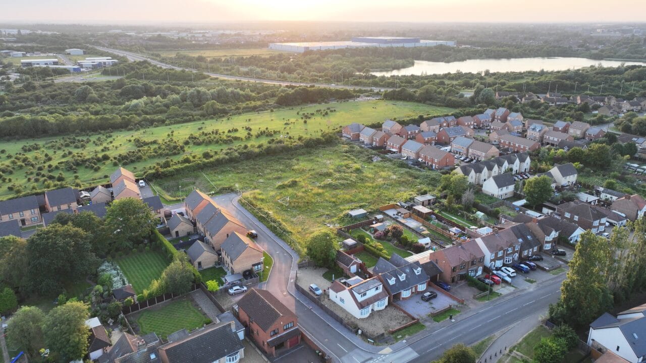
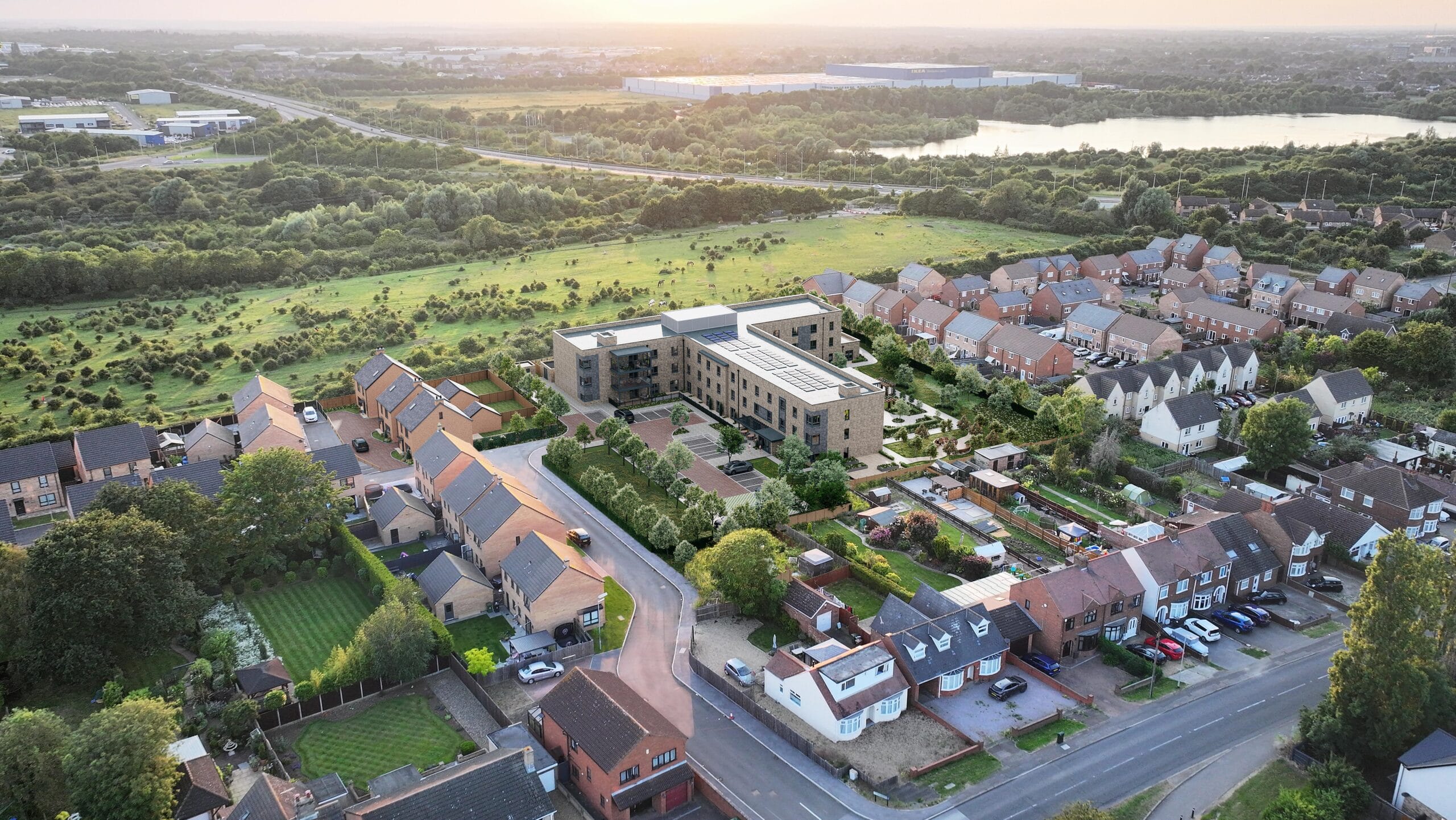
Drone photography is then used to capture high-quality images of the site from various perspectives. AAI Drones plays a crucial role here, as their specialized drones capture aerial shots that cover every angle of the site. These shots are essential, as they provide the background onto which the 3D model will be placed. By capturing multiple angles, the team can choose the most effective one for the final montage or even create several montages to showcase different views.
5. Integrating CGI with Drone Photography
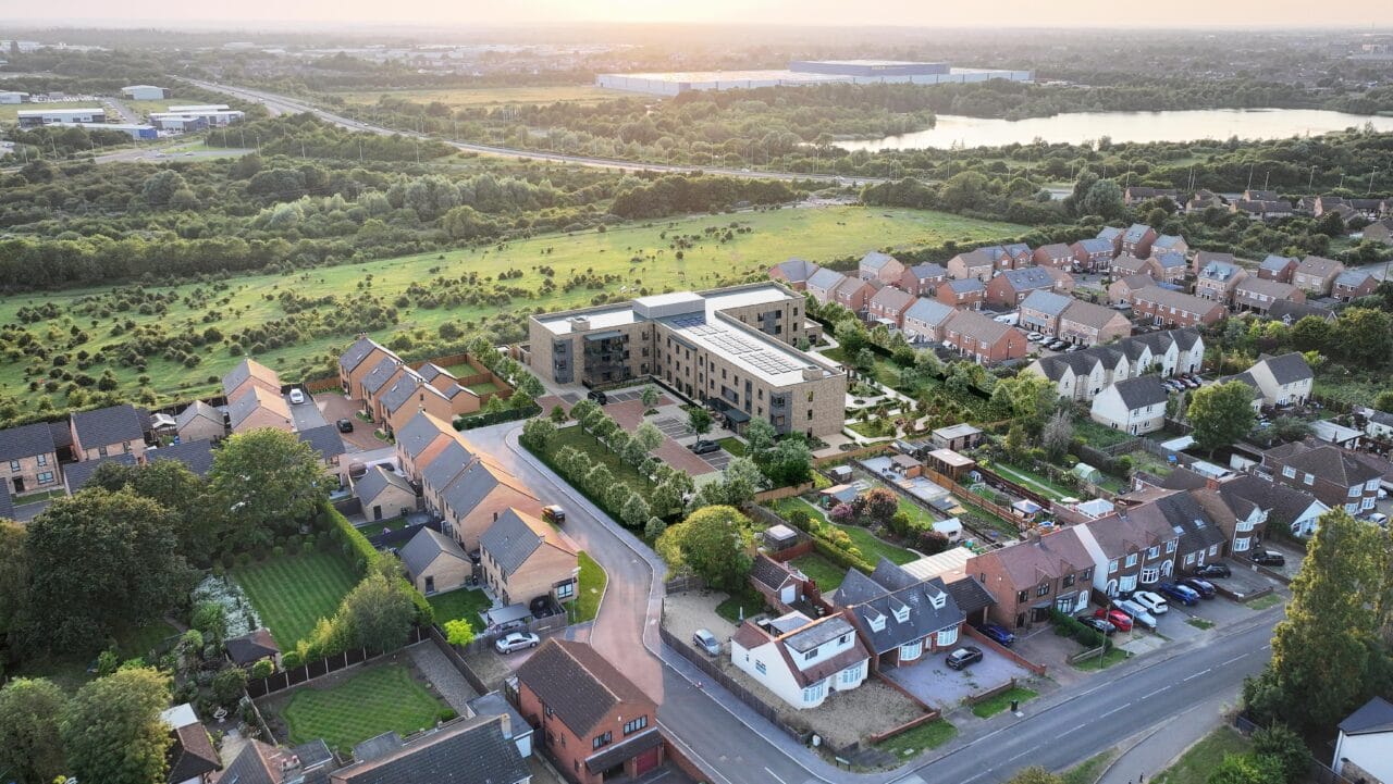
The final stage of the CGI montage involves overlaying the rendered 3D model onto the selected drone photograph. Here, the visual effects expertise of Visual Tricks and CGI Finder comes into play. They meticulously align the 3D model within the drone photo, adjusting lighting, perspective, and shadows to ensure that the CGI building blends seamlessly with the existing environment. This integration, illustrated in the “Drone Photo with CGI Overlay,” creates a convincing representation that shows the development as if it were already built.
Why Drone Photography and CGI?
The combination of drone photography and CGI in architectural visualization offers significant benefits. Drone photography provides high-resolution, real-world images that ground the CGI model in its true context. Meanwhile, CGI enables developers to adjust and refine visual details to make the representation as accurate as possible, highlighting design features and allowing for clear communication with stakeholders. Together, these technologies provide a vivid, immersive preview of future projects, enhancing decision-making and community engagement.
The Positive Partnership between AAI Drones, Visual Tricks, and CGI Finder
This project exemplifies the synergy between AAI Drones, Visual Tricks, and CGI Finder. AAI Drones brings expertise in capturing high-quality aerial images, while Visual Tricks provides skill in aligning 3D models with real-world photography, ensuring that the CGI is seamlessly integrated. CGI Finder facilitates the partnership between Visual Tricks and the developer, ensuring precise rendering and final adjustments to create lifelike images. This collaboration showcases the strengths of both companies and demonstrates the power of combining drone photography with CGI for the real estate and construction industries.
By combining drone photography with CGI, these three companies have created a visually compelling, realistic montage of a future estate that serves as a powerful tool for planning and showcasing architectural developments.
CGI Finder

CGI Finder is an innovative platform that connects clients with skilled 3D artists, streamlining the process of bringing creative projects to life. By offering a comprehensive marketplace for 3D rendering and CGI services, CGI Finder ensures seamless collaboration and high-quality results for businesses and individuals alike.
Visual Tricks

Visual Tricks is a UK-based property CGI studio specializing in high-quality computer-generated imagery (CGI) for the real estate and construction industries. Their services include 3D exterior renderings, internal views, 360° virtual tours, photo montages, and 2D floorplans. With over a decade of experience, they blend architectural and CGI expertise to deliver photorealistic visuals that help clients market properties off-plan more effectively.
AAI Drones
AAI Drones, located in Peterborough, UK, offers professional drone services, including aerial photography and videography for real estate, event coverage, building inspections, and commercial and industrial surveys. Their certified pilots operate advanced drones like the DJI Mavic 3 Pro, DJI Mini 3 Pro, and DJI Matrice 350 RTK, ensuring high-quality imagery and data collection. Committed to safety and compliance, AAI Drones adheres to Civil Aviation Authority (CAA) regulations and holds necessary certifications and insurance.

