Drones equipped with thermal imaging technology are rapidly transforming various sectors, offering unprecedented capabilities for data collection, inspection, and monitoring. These drones, also known as thermal drones or infrared drones, utilize infrared cameras to detect heat signatures, enabling users to “see” temperature differences even in low-light conditions or through obscurants like smoke, fog, or vegetation. This technology has a wide range of applications, from search and rescue operations to building inspections and agricultural monitoring.
What is Thermal Imaging and How Do Drones Use It?
Thermal imaging, also known as infrared thermography, is a non-contact imaging technique that captures and visualizes the temperature distribution of objects and surfaces. Instead of relying on visible light, thermal cameras detect infrared radiation emitted by objects, which is directly related to their temperature. The camera then converts this infrared radiation into an electronic signal, creating an image where different temperatures are represented by different colors or shades.
Drones with thermal cameras combine advanced imaging technology with aerial mobility. These cameras are lightweight and designed to be mounted on drones, allowing for detailed thermal data capture from above. This aerial perspective provides a broader view and access to hard-to-reach areas, making thermal drones more efficient than traditional ground-based methods.
Key Advantages of Using Thermal Drones
Thermal drones offer several advantages over traditional methods:
- Enhanced Visibility: Thermal cameras operate independently of visible light, making them ideal for use in low-light conditions, at night, or in obscured environments like smoke or fog.
- Rapid Detection of Anomalies: Thermal imaging allows for quick identification of temperature variations, enabling prompt responses to issues such as equipment malfunctions or structural defects.
- Greater Coverage: Drones can cover vast areas efficiently, monitoring large and remote areas in a fraction of the time compared to ground-based methods.
- Improved Safety: Drones eliminate the need for risky manual inspections, reducing exposure to hazardous conditions in industries like powerline maintenance, oil and gas, and construction.
- Cost-Effectiveness: Using drones for thermal inspections can be more cost-effective than traditional methods, as it reduces the need for scaffolding, mobile platforms, or extensive manual labor.
- Versatility Across Applications: Thermal drones can be used in various industries, including agriculture, construction, energy, public safety, and environmental monitoring.
Applications Across Industries
1. Search and Rescue
Thermal drones are invaluable tools in search and rescue (SAR) operations, offering unparalleled speed, efficiency, and flexibility to SAR teams. These drones can quickly survey large areas, locate missing persons in low visibility, and provide real-time intelligence.
- Locating Missing Persons: Thermal cameras can detect body heat signatures, even through smoke, heavy fog, or complete darkness. This is particularly useful in difficult terrains like forests, mountains, and urban disaster zones.
- Rapid Aerial Reconnaissance: Drones can survey large areas from above, significantly faster than ground teams, allowing responders to cover expansive territories efficiently.
- Precise Grid Searches: Equipped with programmed grid search capabilities, drones can systematically survey a designated search area, ensuring thorough coverage and eliminating the risk of overlooking critical areas.
- Urban Search and Rescue (USAR): In densely populated urban areas, thermal drones are essential for locating survivors in collapsed structures following earthquakes or building collapses.
- Mountain and Avalanche Rescue: Thermal drones can detect heat signatures beneath snow or rugged terrain, allowing SAR teams to locate trapped or buried individuals quickly.
- Air-Sea Rescue (ASR): In maritime SAR missions, thermal drones assist in locating individuals at sea by detecting their heat signatures against the cooler water.
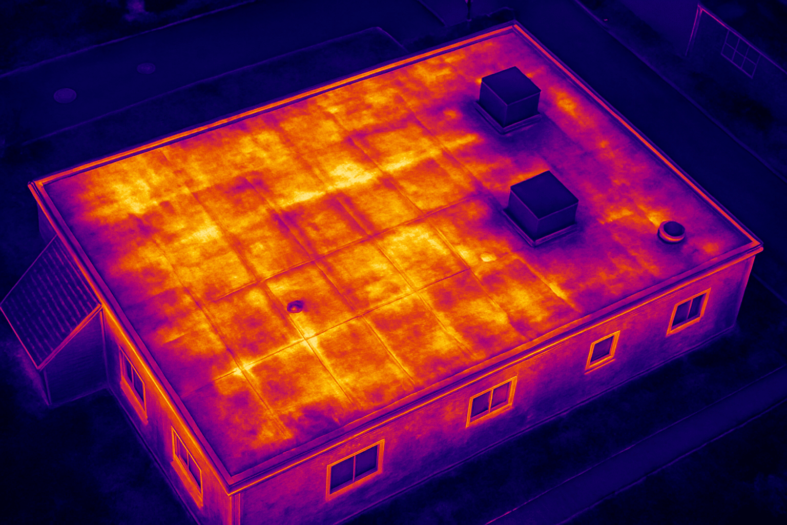
2. Building and Roof Inspections
Thermal imaging drones are revolutionizing building inspections by providing a cost-effective way to assess the condition and energy efficiency of all building types.
- Identifying Heat Loss: Thermal drones can detect areas where insulation is compromised, leading to energy inefficiency. They can identify heat escaping through poorly insulated roofs, walls, and windows.
- Detecting Water Intrusion: Thermal imaging can spot moisture accumulation under roofing materials by identifying temperature anomalies. This helps in detecting leaks in roofs, walls, and foundations.
- Structural Inspections: Thermal drones help detect structural issues and inefficiencies, enabling faster and more accurate assessments of roofing systems. They can reveal cracks, gaps, and other defects in building facades that are not visible to the naked eye.
- Sub-Surface Water Leaks: Thermal drones can detect sub-surface water leaks from district heating networks or water সরবরাহ systems. On cold mornings, any escaped water is clear on the thermal image.
- Compliance with Standards: Detailed thermal reports ensure compliance with regulatory standards, making it easier for facility managers, engineers, and asset owners to prioritize maintenance and optimize system performance.
3. Agriculture and Environmental Monitoring
Thermal drones are increasingly used in agriculture and environmental monitoring to improve crop yields, manage resources, and protect ecosystems.
- Crop Health Monitoring: Thermal drones can monitor the health of crops by detecting temperature variations that indicate water stress, pest infestations, or disease outbreaks. This allows farmers to take targeted action, such as adjusting irrigation or applying pesticides only where needed.
- Livestock Monitoring: Farmers use thermal drones to monitor livestock, especially in large pastures or rugged terrain. The drones can locate animals, check for signs of illness (e.g., elevated body temperature), and even assist in herding.
- Irrigation Management: Thermal drones help monitor soil moisture levels by detecting temperature differences in dry and overwatered areas. This enables precision irrigation, ensuring crops receive optimal water levels, which reduces waste and improves yields.
- Wildlife Monitoring and Conservation: Thermal drones are used to track wildlife, especially in dense forests or during the night when visual observation is challenging. This non-intrusive method allows researchers to monitor animal behavior, migration patterns, and population dynamics without disturbing the animals.
- Environmental Condition Monitoring: Thermal drones are employed in monitoring environmental conditions, such as tracking temperature changes in rivers and lakes or detecting illegal logging activities in forests.
4. Energy and Industrial Inspections
Thermal imaging drones play a crucial role in optimizing energy systems and maintaining critical infrastructure.
- Solar Panel Inspections: Thermal drones are invaluable for inspecting solar farms, identifying defective solar panels, hotspots, and areas of reduced efficiency.
- Power Line Monitoring: Drones can detect overheating components in electrical systems, such as power lines and substations, identifying potential points of failure. This allows engineers to take pre-emptive measures, preventing costly power outages and improving network reliability.
- Wind Turbine Inspections: Thermal drones can assess the condition of wind turbines, detecting structural issues and inefficiencies.
- Gas Leak Detection: Thermal cameras can efficiently detect gas leaks that are hazardous for human health and the environment by visualizing them.
- Infrastructure Monitoring: Thermal imaging drones are employed to monitor critical infrastructure, such as bridges, pipelines, dams, and railways, for signs of structural deterioration, corrosion, or thermal stress.
5. Public Safety and Firefighting
Thermal drones are powerful tools for enhancing public safety and improving emergency response operations.
- Fire Management: Thermal imaging drones are revolutionizing fire management by providing real-time heat detection and monitoring. They can quickly identify hidden hotspots, track fire progression, and deliver accurate data, enabling faster responses and more efficient resource allocation.
- Hotspot Detection: Drones equipped with thermal cameras excel in hotspot detection by scanning vast terrains with precision. They can detect temperature anomalies that might go unnoticed by traditional methods, even in challenging environments with heavy smoke or dense foliage.
- Identifying Fire Spread: Thermal drones help firefighters detect hidden dangers and track fire progression in real time.
- Law Enforcement: Thermal drones can be used for border security, crowd monitoring, and suspect tracking, enabling authorities to detect threats in low-visibility environments.
Choosing the Right Thermal Drone
Selecting the right thermal drone depends on the specific application and requirements. Key factors to consider include:
- Thermal Camera Resolution: Higher resolution thermal cameras provide more detailed and accurate thermal data.
- Flight Time: Longer flight times allow for more extensive surveys and inspections.
- Payload Capacity: The drone’s payload capacity determines the type and size of thermal camera and other sensors it can carry.
- Environmental Conditions: Consider the drone’s ability to operate in various weather conditions, such as rain, snow, and wind.
- Software and Analytics: Choose a drone with compatible software for data analysis and interpretation.
- Budget: Thermal drones range in price from a few thousand to tens of thousands of dollars, so it’s essential to set a budget and find a drone that meets your needs within that budget.
Some popular thermal drone models include the DJI Mavic 3 Thermal, DJI Matrice series (30T, 350 RTK), Autel EVO series (Max 4T, EVO II Dual 640T), and Teledyne FLIR SIRAS.
Regulations and Legal Considerations in the UK
Operating drones with thermal cameras in the UK requires adherence to specific regulations. The Civil Aviation Authority (CAA) oversees drone operations and has established guidelines to ensure safety and privacy.
Key regulations include:
- CAA Licensing: Commercial drone operators must obtain a CAA license.
- Registration: Operators of drones with cameras or which weigh more than 250g must register with the CAA and pass an online theory test to get a Flyer ID.
- Operating Restrictions: Drones must be flown within visual line of sight (VLOS) and below 400 feet (120 meters).
- Privacy Considerations: Operators must be mindful of privacy concerns when conducting thermal imaging.
- Specific Operations Risk Assessment (SORA): From April 2025, the CAA will adopt the SORA methodology to evaluate and approve higher-risk drone operations.
It is crucial to stay informed and ensure compliance with these regulations to operate thermal drones legally in the UK.
The Future of Thermal Drone Technology
As technology continues to advance, thermal drones are expected to become even more powerful and versatile. Future trends include:
- AI-Powered Analytics: Integration of artificial intelligence (AI) and machine learning algorithms for real-time data analysis and predictive maintenance.
- Improved Sensor Technology: Development of more sensitive and higher-resolution thermal cameras.
- Enhanced Automation: Increased use of autonomous flight and data collection capabilities.
- Expanded Applications: Exploration of new applications for thermal drones in emerging industries.
With their ability to provide valuable insights across a wide range of industries, thermal drones are poised to play an increasingly important role in the future. From enhancing safety and efficiency to improving resource management and protecting the environment, these “thermal eyes in the sky” are transforming the way we see and interact with the world.


