Drone 360 photography is revolutionizing how we capture and experience the world around us. By combining the unique aerial perspective of drones with immersive 360-degree imagery, it opens up exciting possibilities for various industries and applications. This article dives deep into the world of drone 360 photography, covering everything from essential equipment and techniques to regulations and inspiring use cases in the UK.
What is Drone 360 Photography?
Drone 360 photography involves using drones equipped with specialized cameras to capture a complete, spherical image of an environment. Unlike traditional photos or videos that only show one angle, a 360-degree image allows viewers to explore the entire scene, looking left, right, up, and down, creating an immersive and interactive experience. This technology essentially puts the viewer in the pilot’s seat, allowing them to explore the environment from every possible angle.
How Does it Work?
The process of creating 360 drone imagery involves several key steps:
- Site Planning and Assessment: Before any flight, a thorough assessment of the site is conducted, considering factors like layout, potential obstacles, safety zones, and flight paths. Airspace restrictions and weather conditions are also checked to ensure compliance with UK Civil Aviation Authority (CAA) guidelines.
- Drone Flight and Image Capture: Drones equipped with 360-degree cameras are used to capture images. These cameras typically have multiple lenses pointing in different directions. As the drone hovers or flies to specific points, the cameras capture a full set of images covering every angle. Some shots are taken from fixed positions to offer still panoramas, while others are captured in a sequence for moving virtual tours or mapped flyovers.
- Image Stitching and Processing: The captured images are then processed using specialized software that aligns and blends the overlapping photos into a seamless 360-degree panorama. This process requires a trained eye and a steady hand to ensure perfect alignment and a visually appealing final product. Adjustments to lighting, sharpness, and orientation are also made during this stage.
Benefits of Drone 360 Photography
The use of drone 360 photography offers numerous advantages over traditional methods:
- Full Visibility: Viewers have complete control to explore the entire scene in their own time, from every possible angle. This transparency builds trust, especially for industries like property sales, infrastructure, and environmental reporting.
- Remote Access: 360 drone imaging allows clients, stakeholders, or inspectors to explore sites in remote, hazardous, or restricted areas without being physically present. This saves time, cuts travel costs, and improves safety.
- Enhanced Engagement: 360-degree images provide an engaging way to showcase venues, events, or properties, boosting customer engagement and improving online visibility.
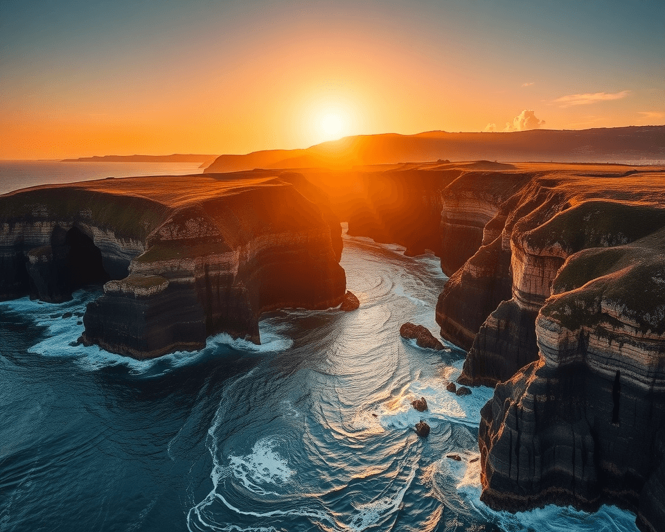
- Unique Perspective: Drones can capture breathtaking aerial images and provide a unique experience, offering views that would be difficult or impossible to achieve from the ground.
- Multimedia Content Creation: 360-degree cameras are ideal for capturing quality multimedia content, which can be used to assemble complete audiovisual pieces, such as films, documentaries, or series.
- Marketing Advantage: Real estate properties marketed with drone photography can sell homes nearly 68 percent faster.
Essential Equipment for Drone 360 Photography
To capture high-quality aerial panoramas, you’ll need specific equipment:
- Drone: Choose a model with GPS stabilization and programmable flight modes for stable and consistent shots.
- Camera: Use a high-resolution camera with manual controls to optimize image quality.
- 360-degree Camera: Select a camera specifically designed for 360 photography, such as the Insta360 Sphere, which is designed to work seamlessly with drones.
- Gimbal: Ensure smooth, stable footage with a 3-axis gimbal to compensate for drone movements.
- Memory Cards: Opt for fast, high-capacity cards to store multiple high-resolution images.
- Software: Invest in panorama stitching software for post-processing and creating seamless 360-degree images.
Recommended Drones for 360 Photography
- DJI Mini 4 Pro: Compact, lightweight, and offers excellent image quality, making it ideal for beginners and those who want to skip FAA registration (in the US).
- DJI Air 3: A versatile drone with extended battery life and dual lenses, providing greater flexibility for aerial photography.
- DJI Mavic 3 Pro: A premium choice for professional-quality images and videos, featuring a Hasselblad Four Thirds camera and multiple telephoto lenses.
- Autel Robotics Evo Lite+: Known for its exceptional photography capabilities and high-end equipment for crystal-clear 360 capture.
360-Degree Cameras for Drones
- Insta360 Sphere: Specifically designed to work with the Mavic Air 2/2S, this camera makes the drone virtually invisible in the final image. It shoots 5.7K 360 video and offers excellent stabilization.
- Ricoh Theta Z1: A flagship 360 camera known for its exceptional optical and image processing technologies, delivering high-resolution and quality.
- Insta360 One X2: A versatile and compact 360 camera that is suitable for smaller drones and offers impressive stabilization.
Techniques for Capturing Stunning 360 Drone Photos
Mastering aerial panorama capture requires specific shooting techniques:
- Overlap Images: Overlap images by 30-40% to ensure seamless stitching in post-processing.
- Use a Grid Pattern: Employ a grid pattern to ensure complete coverage of the area.
- Maintain Consistent Altitude: Keep the drone at a consistent altitude throughout the shoot to avoid perspective distortions.
- Rotate Around Axis: Rotate the drone around its axis for smooth and comprehensive 360-degree panoramas.
- Shoot in Landscape: Capture images in landscape orientation to maximize vertical coverage.
- Camera Settings: Use manual mode to maintain consistent exposure across all images. Keep ISO low (100-400) to minimize noise, and use an aperture between f/5.6 to f/8 for optimal sharpness.
Post-Processing and Stitching
After capturing the images, the next step is to stitch them together to create a seamless 360-degree panorama:
- Import RAW Files: Import the RAW files into your chosen editing software, such as Adobe Lightroom or PTGui.
- Apply Basic Adjustments: Uniformly adjust exposure, contrast, and white balance to ensure consistency across all images.
- Use Stitching Software: Utilize dedicated stitching software like PTGui, PanoVolo, or Autopano Giga to align and blend the images.
- Adjust Blending Options: Smooth transitions between images by adjusting blending options.
- Correct Distortion: Fix any distortion or alignment issues to create a seamless panorama.
- Crop the Image: Remove irregular edges and finalize the image by cropping it to the desired dimensions.
Recommended Software for Stitching and Post-Processing
- PTGui: Image stitching software for creating seamless 360-degree spherical panoramas.
- PanoVolo: A Windows/Mac app designed specifically for drone photographers, offering high-quality output with minimal fuss.
- Autopano Giga: A powerful tool for automatically stitching multiple photos into a seamless panorama.
- Adobe Photoshop/Lightroom: Versatile software options for basic adjustments and panorama creation.
- Hugin: A free and open-source panorama photo stitcher with an OpenGL panorama viewer.
Regulations and Safety Guidelines in the UK
Operating drones for commercial purposes in the UK is subject to specific regulations and safety guidelines set by the Civil Aviation Authority (CAA):
- Registration: Anyone wishing to fly a drone needs to register with the CAA. It is illegal to fly a drone without being registered.
- Flyer ID and Operator ID: You need to be registered with both a Flyer ID and Operator ID before you can fly your drone that should weigh 250g through to 20kg.
- CAA Permission: Anyone offering services like drone roof inspections and drone wedding photography for payment must have approval to operate from the Civil Aviation Authority (CAA).
- Distance Restrictions: There is a 50m restriction when flying your drone near any people, buildings, vehicles, or vessels. This increases to 150m in congested areas or large groups of people.
- Privacy and Data Protection: If you plan to record or take images where there are people, you need to inform these people prior to the event.
- Insurance: Commercial drone operators must have drone public liability insurance.
- Training and Qualifications: Pilots must pass CAA-approved exams and flight assessments to obtain the necessary qualifications.
Use Cases for Drone 360 Photography
Drone 360 photography is being used across a wide range of industries:
- Real Estate: Showcasing properties from every angle, allowing buyers to explore neighborhoods, gardens, and surrounding areas without leaving their screen.
- Construction and Site Management: Tracking project progress, creating virtual walk-throughs for clients, and keeping a record of development over time. 360 imaging also helps with site planning and risk assessment.
- Tourism and Events: Promoting destinations, venues, or festivals with immersive content that draws people in. Perfect for travel sites, experience-based brands, or local authorities.
- Virtual Tours: Enhancing virtual tours by providing aerial perspectives of locations, businesses, or facilities.
- Infrastructure Inspection: Inspecting bridges, power lines, and other infrastructure remotely, saving time and improving safety.
- Environmental Monitoring: Getting a full picture of land conditions and environmental change in just one flight.
Inspiring Examples in the UK
Several companies and organizations in the UK are already leveraging drone 360 photography to create stunning and immersive experiences:
- HeliDrone Surveys: Specializes in cutting-edge aerial imaging, offering 360 drone photography for clients across construction, real estate, tourism, and energy.
- CloudVisual: Creates ultra-high-resolution 360° panoramas tailored to specific needs, compatible with Facebook, Google Street View, and virtual reality platforms.
- Eye Revolution: Offers aerial 360 photography and video, providing context and unique perspectives for various locations. Examples include aerial 360s over the River Thames and Hampstead Heath.
- The Virtual Tour Experts: Created a stunning visual tour for the small estuary town of Topsham in Devon, showcasing the region and allowing users to explore key points of interest.
- AmbientLight: Offers Drone 360° spins that work great as an introductory view in virtual tours for larger sites like schools, venues, universities and sports centres.
The Future of Drone 360 Photography
As drone technology continues to evolve, we can expect even more exciting developments in the field of 360 photography. Future trends may include:
- Higher Resolution Cameras: Drones equipped with even higher resolution cameras will capture more detailed and immersive 360-degree images.
- AI-Powered Processing: Artificial intelligence will play a greater role in image stitching and processing, automating tasks and improving the quality of final panoramas.
- Real-Time 360 Streaming: Live streaming of 360-degree video from drones will become more common, opening up new possibilities for remote monitoring, event coverage, and virtual tourism.
- Integration with VR/AR: Drone 360 photography will be seamlessly integrated with virtual and augmented reality technologies, creating even more immersive and interactive experiences.
Drone 360 photography offers a powerful way to capture and share the world around us. Whether you’re a professional photographer, a business owner, or simply an enthusiast, exploring the possibilities of this technology can open up new creative and commercial opportunities. By understanding the equipment, techniques, and regulations involved, you can create stunning 360-degree panoramas that will captivate and engage your audience.


