Drone 3D modeling is revolutionizing how we visualize and interact with the world around us. By capturing aerial images and processing them with sophisticated software, drones are creating detailed, accurate 3D models for various industries. This article explores the world of drone 3D modeling, its applications, and its transformative potential.
What is Drone 3D Modeling?
Drone 3D modeling involves using unmanned aerial vehicles (UAVs), or drones, equipped with cameras and sensors to capture high-resolution images of a subject or area. These images are then processed using photogrammetry or LiDAR (Light Detection and Ranging) techniques to create detailed, three-dimensional models. This technology enables the creation of digital representations of physical environments with remarkable precision.
How Does Drone 3D Modeling Work?
The process of drone 3D modeling typically involves these steps:
- Project Planning and Preparation: Defining the project scope, identifying the area or object to be modeled, and planning the drone’s flight path are crucial first steps. Proper planning ensures efficient data collection and optimal results.
- Data Acquisition: The drone flies over the designated area, capturing numerous overlapping images from different angles. These images are geo-tagged, meaning they are embedded with geographical data, including altitude, longitude, and latitude measurements.
- Data Processing: Specialized software processes the captured images, using photogrammetry or LiDAR techniques to create a 3D point cloud. This point cloud is a set of data points in three-dimensional space, representing the external surfaces of objects.
- Model Refinement: The point cloud is further processed to create a 3D mesh, which is a digital representation of the surface. Textures from the original images are then applied to the mesh, creating a realistic 3D model.
- Analysis and Application: The final 3D model can be used for various purposes, including measurements, analysis, visualization, and integration into other software platforms.
Photogrammetry vs. LiDAR
Two primary techniques are used in drone 3D modeling:
- Photogrammetry: This method uses overlapping photographs to create 3D models. Software identifies common points in multiple images and triangulates their positions in 3D space.
- LiDAR: LiDAR uses lasers to measure the distance between the drone and the ground or objects below. The laser pulses bounce off surfaces, creating a highly accurate 3D point cloud.
Applications of Drone 3D Modeling
Drone 3D modeling is transforming various industries, offering enhanced precision, efficiency, and safety.
Construction and Infrastructure Development
- Planning and Surveying: Drones provide accurate land surveys and topographic data for planning construction projects.
- Progress Monitoring: Drones monitor project progress, track resources, and help manage assets on-site.
- Inspections: Drones inspect structures for wear, tear, or damage, enabling regular maintenance checks for bridges, roads, and buildings.
Urban Planning and Real Estate
- City Modeling: Drones create accurate, up-to-date 3D models of entire cities for better planning and zoning decisions.
- Infrastructure Planning: Municipal teams use drone mapping to create models of neighborhoods for zoning and infrastructure development.
- Real Estate Visualization: Drones generate realistic 3D models of properties for marketing and sales purposes.
Agriculture and Forestry
- Terrain Analysis: Farmers use 3D models of farmland to understand topography and soil conditions.
- Crop Monitoring: Drones help identify issues such as soil erosion and crop diseases.
- Forest Management: Drones assist in forest inventory, health assessment, and conservation efforts.
Environmental Monitoring and Disaster Management
- Ecosystem Monitoring: Drones track changes in ecosystems and analyze their impact.
- Damage Assessment: Drones quickly produce 3D models of disaster-affected areas for better understanding and strategy planning.
- Coastal Erosion Monitoring: Drones monitor coastal changes and erosion patterns.
Mining and Geology
- Stockpile Measurement: Mines use drone surveys to measure stockpile volumes and monitor pits and slope angles.
- Terrain Mapping: Drones provide detailed terrain models for geological analysis and resource exploration.
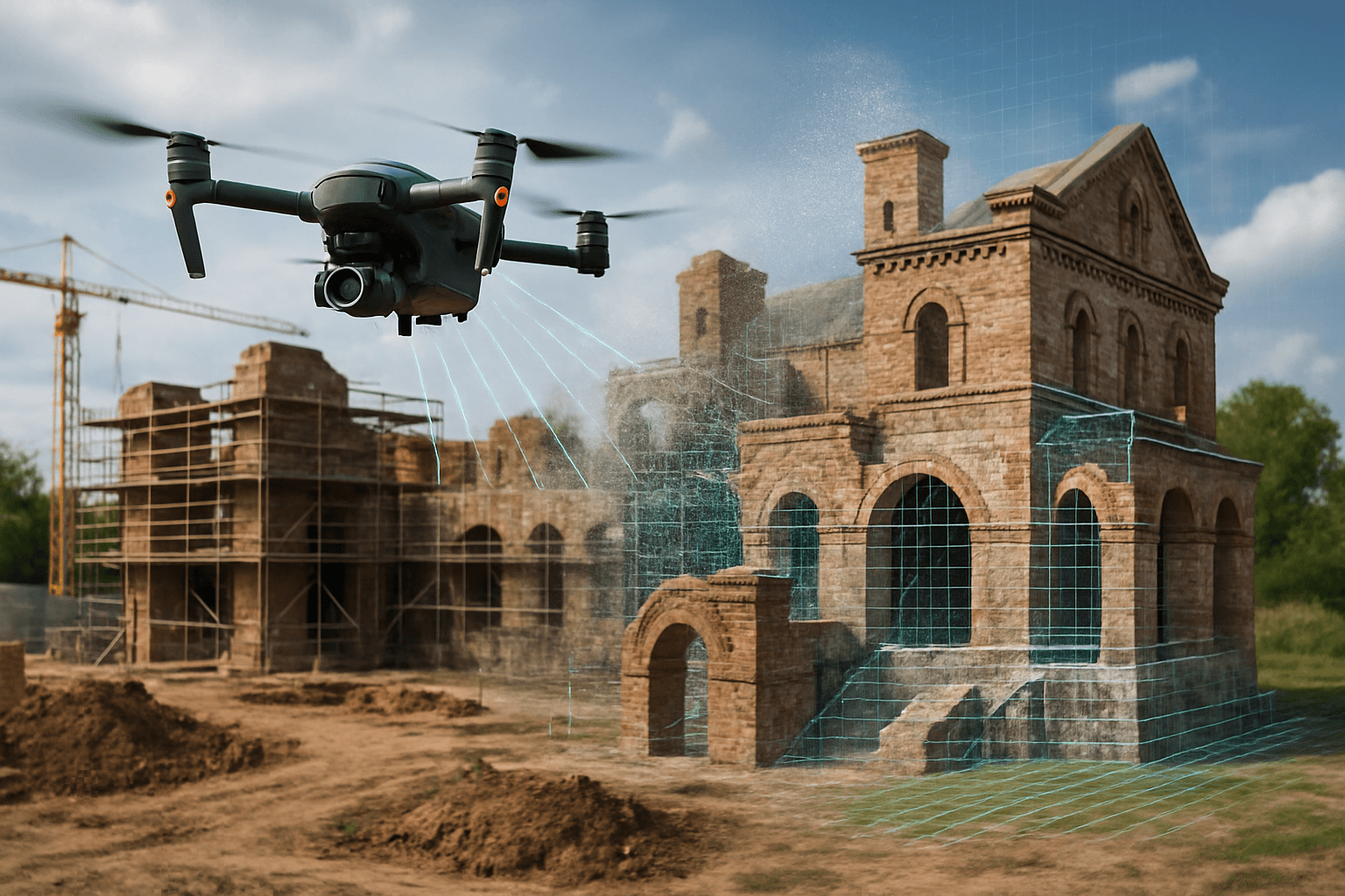
Archaeology and Cultural Heritage
- Site Documentation: Drones create historical documentation of archaeological sites and cultural heritage landmarks.
- Preservation: The detailed models support restoration, conservation, and architectural analysis.
Energy and Utilities
- Inspection of Assets: Energy companies use drone 3D models to inspect intricate assets and operations from a safe distance.
- Power Line Inspection: Drones inspect power lines for damage or wear.
Benefits of Drone 3D Modeling
Drone 3D modeling offers several advantages over traditional methods:
- Enhanced Precision and Detail: Drones capture high-resolution imagery, providing detailed and accurate 3D models.
- Cost Efficiency: Drones reduce the time and manpower needed for data collection, making it more economical.
- Accessibility and Safety: Drones access steep terrains, disaster zones, and hazardous environments safely.
- Time Efficiency: Drones cover vast areas in a fraction of the time compared to traditional methods.
- Comprehensive Data Analysis: Drones provide comprehensive data for informed decision-making.
- Improved Visualization: Interactive 3D models offer better-informed decisions throughout project lifecycles.
- Real-time Monitoring: Drones enable real-time monitoring of project progress and site conditions.
- Remote Diagnostics: Facilitating remote diagnostics, degradation monitoring, and predictive maintenance.
Drone 3D Modeling Workflow
The process of creating 3D models with drones involves several key steps:
- Project Planning and Preparation:
- Define the project scope and objectives.
- Identify the area or object to be modeled.
- Plan the drone flight path, considering factors like altitude, overlap, and camera angles.
- Obtain necessary permits and permissions.
- Data Acquisition:
- Use a drone equipped with a high-resolution camera or LiDAR sensor.
- Capture numerous overlapping images or LiDAR data from different angles.
- Ensure proper lighting conditions and minimize shadows.
- Use ground control points (GCPs) for accurate georeferencing.
- Data Processing:
- Upload the captured data to specialized photogrammetry or LiDAR processing software.
- Align the images or point cloud data.
- Generate a dense point cloud or mesh.
- Apply textures and colors to create a realistic 3D model.
- Model Refinement:
- Clean up the model by removing unwanted objects or noise.
- Optimize the model for specific applications, such as reducing file size or improving accuracy.
- Add annotations, measurements, or other relevant information.
- Analysis and Application:
- Use the 3D model for visualization, analysis, and decision-making.
- Integrate the model into other software platforms, such as GIS, CAD, or BIM.
- Share the model with stakeholders for collaboration and feedback.
Step-by-Step Workflow with DJI Drones
DJI, a leading drone manufacturer, offers a streamlined workflow for 3D modeling using its drones and software:
- Rough Model Generation: Fly the drone over the target area to generate a rough 3D point cloud model using DJI Pilot 2 software.
- Flight Route Planning: Define the survey area, and the drone generates an automated flight plan with adjustable parameters.
- Route Execution: Execute the route with multi-directional oblique capture to gather detailed data.
- Survey Quality Review: Evaluate the captured data using a quality report to ensure the model meets standards.
- Data Processing: Finalize the 3D model by importing data into DJI Terra for high-resolution reconstruction and detailed analysis.
Best Practices for Drone 3D Modeling
To achieve high-quality 3D models, consider these best practices:
- High-Quality Data: Use high-quality data for successful 3D modeling, capturing detailed aerial imagery.
- Optimal Flight Time: Time flights to avoid strong shadows and ensure consistent lighting.
- Nadir Imagery: Capture nadir imagery with the camera pointing directly at the ground.
- Oblique Imagery: Capture oblique imagery from different angles to enhance detail.
- Sufficient Overlap: Ensure sufficient overlap between images for accurate reconstruction.
- Camera Calibration: Proactively calibrate the camera to ensure accuracy.
- Ground Control Points (GCPs): Use GCPs to improve the accuracy of the 3D model by providing known reference points.
Challenges of Drone 3D Modeling
Despite its numerous benefits, drone 3D modeling presents certain challenges:
- Vegetation Obstruction: Dense vegetation can obstruct views and lead to incomplete models.
- Weather Conditions: Adverse weather conditions like strong winds, rain, or fog can impede flights.
- Technical Expertise: Drone modeling requires expertise in drone piloting, data processing, and software operation.
- Data Processing Requirements: High-resolution sensors generate vast amounts of data, leading to storage and processing challenges.
- Site Terrain and Accessibility: Uneven or rocky terrain can create takeoff and landing challenges.
- Regulatory Compliance: Drones must be operated in compliance with local regulations and airspace restrictions.
Overcoming Challenges
Strategies to overcome these challenges include:
- Flying at Optimal Altitudes: Balance detail and coverage by adjusting flight altitudes.
- Using Additional Data Sources: Complement drone data with videogrammetry or ground-based imagery.
- Employing Advanced Machine Learning: Enhance model performance and efficiency with advanced machine learning techniques.
Drone 3D Modeling Software
Several software options are available for processing drone imagery and creating 3D models:
- Pix4Dmapper: A PC application focused on 2D orthomosaic and 3D model reconstruction.
- DJI Terra: A 3D model reconstruction software that supports 2D and 3D reconstruction of visible light and LiDAR data.
- OpenDroneMap™: A command-line toolkit to process aerial images, with user-friendly applications like WebODM.
- RealityCapture: A software program for compiling drone images into 3D models.
- DroneDeploy: A cloud-based platform for drone mapping and 3D modeling.
- Polycam: A free drone photogrammetry software for creating 3D models from drone images and videos.
Accuracy of Drone 3D Models
The accuracy of drone-generated 3D models depends on several factors:
- Equipment and Techniques: Accuracy typically ranges from centimeter-level to millimeter-level precision.
- Flight Altitude: Lower flight altitudes generally result in higher accuracy.
- Ground Control Points (GCPs): Using GCPs significantly improves accuracy.
- Drone Sensors: The quality of the drone’s camera and sensors affects the accuracy of the data.
Ensuring Accuracy
To ensure the highest possible accuracy:
- Use High-Resolution Sensors: Employ drones with high-resolution cameras or LiDAR sensors.
- Apply Best Practices: Follow recommended flight planning and data processing techniques.
- Utilize Ground Control Points: Incorporate GCPs to anchor the model to real-world coordinates.
UK Drone Regulations for 3D Modeling
In the UK, drone operations are regulated by the Civil Aviation Authority (CAA). Key regulations include:
- Registration: Drones weighing 250g or more must be registered with the CAA.
- Operator and Flyer IDs: Drone pilots must have a valid operator ID and a flyer ID.
- Altitude Limit: Drones must not be flown above 400 feet (120 meters).
- Distance from People: Drones must be kept at least 50 meters away from people and properties not under the pilot’s control, and 150 meters away from gatherings of 1,000 or more people.
- Visual Line of Sight: Pilots must maintain a visual line of sight with the drone at all times.
- No-Fly Zones: Drones must not be flown within 5 kilometers of airport boundaries without permission.
Compliance with Regulations
To comply with UK drone regulations:
- Check for Airspace Restrictions: Before flying, check for any airspace restrictions or temporary restrictions.
- Obtain Necessary Approvals: Obtain specific approvals to operate drones within prohibited areas or flight restriction zones.
- Stay Informed: Stay up-to-date with the latest regulations and guidelines provided by the CAA.
The Future of Drone 3D Modeling
The future of drone 3D modeling is bright, with ongoing advancements in technology and increasing adoption across industries. As drones become more sophisticated and software algorithms improve, we can expect even more detailed, accurate, and efficient 3D models. AI-powered drones will play a significant role, enabling autonomous operation and complex data analysis.
Drone 3D modeling is revolutionizing how we capture, visualize, and interact with the world around us, offering unprecedented opportunities for innovation and progress.


