Earthquakes pose a persistent and devastating threat, capable of causing widespread destruction and loss of life within moments. Traditional earthquake monitoring and early warning systems (EEWS) often rely on fixed ground-based seismic networks, which, despite their critical role, face limitations in terms of spatial coverage, deployment in hazardous or inaccessible terrains, and the speed of data acquisition. The imperative for faster, more comprehensive, and safer seismic data collection has propelled a significant shift towards innovative solutions. Among these, drone-based seismic sensors are emerging as a transformative technology, promising to revolutionize earthquake early warning, research, and disaster response.
The Drone Advantage in Seismology
Unmanned Aerial Vehicles (UAVs), commonly known as drones, offer a compelling array of advantages over conventional methods for seismic data acquisition. Their ability to rapidly deploy across vast or challenging landscapes, including mountains, deserts, and post-disaster zones, significantly enhances operational efficiency and safety.
Key benefits include:
- Improved Operational Efficiency: Drones can cover larger areas in less time, reducing the need for extensive ground crews and resulting in significant cost savings and faster project completion. What might take hours for human crews can be accomplished in a fraction of the time by a drone.
- Enhanced Safety and Accessibility: Many seismic survey environments are hazardous or difficult for human personnel to access due to terrain, unstable conditions after an earthquake, or remote locations. Drones can navigate these areas safely, mitigating risks to human life.
- Flexibility and Customization: Modern drone systems feature modular designs, allowing operators to easily modify sensor payloads and adjust flight parameters for a wide range of seismic scenarios, from shallow subsurface mapping to deep geological exploration.
- High-Resolution Data and Real-Time Transmission: Drones can carry advanced sensors to collect high-resolution seismic information and transmit data in real-time for immediate review and adjustments, crucial for time-critical decisions in early warning systems.
Sensor Technologies and Integration
The effectiveness of drone-based seismic sensing hinges on the integration of sophisticated sensor technologies. Miniaturization has been a key enabler, allowing powerful geophysical instruments to be carried by smaller, more agile UAVs.
Primary sensor types integrated with drones for seismic applications include:
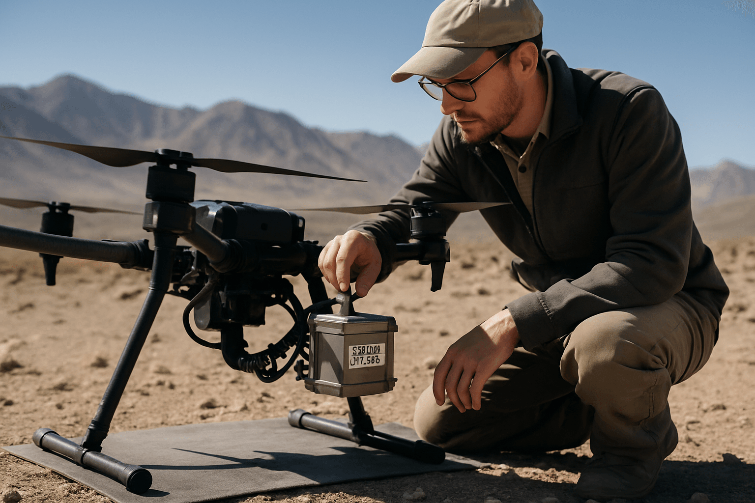
- Geophones and Accelerometers: These are fundamental to seismic monitoring, detecting ground movement (velocity) and converting it into electrical signals. Miniaturized geophones and accelerometers, often based on Micro-Electro-Mechanical Systems (MEMS) technology, are compact and energy-efficient, making them ideal for drone integration. Some drone prototypes are designed with geophones as part of their landing gear to ensure reliable coupling with the ground upon landing.
- Magnetometers: While primarily used for magnetic surveys, magnetometers can complement seismic data by detecting variations in the Earth’s magnetic field, which can be influenced by geological structures.
- LiDAR (Light Detection and Ranging): LiDAR systems onboard drones can generate highly accurate 3D digital elevation models of terrain, crucial for precise sensor placement and understanding the topography of seismic areas.
- Multi-spectral and Thermal Cameras: These provide valuable visual and thermal data for surface feature mapping, identifying geological structures, assessing damage post-earthquake, and even locating survivors by detecting heat signatures.
Sensor integration often involves combining multiple instruments into a single, compact system to boost functionality and reduce overall size, weight, and cost.
Deployment and Data Acquisition Strategies
One of the most innovative aspects of drone-based seismic sensing is the method of sensor deployment and data acquisition. Traditionally, this involved labor-intensive manual placement of numerous sensors across vast areas. Drones offer automated and semi-automated solutions:
- Autonomous Deployment and Recovery: Researchers are developing systems where drones can autonomously deploy seismic nodes (sensors with integrated recorders and batteries) with high precision, sometimes by “dropping” them onto the surface. For successful data acquisition, especially for active seismic surveys, reliable coupling between the sensor and the ground is essential, and ongoing research focuses on improving this aspect.
- Swarm Robotics: The concept of using a “swarm” of autonomous UAVs, each equipped with seismic sensors, is being actively researched. This allows for the rapid and dense deployment of a large number of sensors over a wide area, enhancing the resolution and coverage of seismic surveys. Swarm control stations manage flight paths and data collection, optimizing coverage and efficiency.
- Real-Time Data Transmission: Once deployed, these sensors can transmit data wirelessly to a central ground station or even to other aerial platforms (like helicopters acting as relays) using advanced communication systems such as 4G, 5G, or dedicated RF links. This real-time data flow is paramount for earthquake early warning systems, allowing for immediate analysis and rapid decision-making.
Applications in Earthquake Early Warning and Research
Drone-based seismic sensors hold immense potential across the entire spectrum of earthquake management, from long-term research to immediate disaster response.
Pre-event Monitoring and Prediction Research
By deploying sensitive seismic sensors in seismically active but difficult-to-access regions, drones can collect continuous data on microseismic activity – tiny seismic events often imperceptible to humans. This microseismic monitoring helps in understanding the fracturing of rock formations and identifying potential warning signs of larger seismic events. The mobility of drones allows for flexible repositioning of geophones, enabling targeted surveillance of specific fault lines or areas of interest, which could contribute to advancements in earthquake prediction models.
Earthquake Early Warning Systems (EEWS)
For immediate earthquake early warning, the speed and real-time data capabilities of drone-based systems are critical. EEWS typically detect the arrival of the faster, less destructive P-waves (primary waves) to provide precious seconds or minutes of warning before the arrival of the slower, more destructive S-waves (secondary waves). Drones, equipped with rapidly deployable and connected sensors, can potentially:
- Augment Existing Networks: Fill gaps in traditional seismic networks, especially in remote or hazardous areas, creating a denser and more comprehensive monitoring grid.
- Expedite P-wave Detection: By providing more localized and real-time data, drones can potentially enhance the speed and accuracy of P-wave detection, thereby maximizing the warning time for affected populations.
- Integrate with IoT and AI: Real-time data from drone-based sensors can be fed into Internet of Things (IoT) platforms and analyzed by Artificial Intelligence (AI) and Machine Learning (ML) algorithms. This integration can enhance the interpretation of seismic data, predict geological formations, and quickly disseminate alerts, enabling rapid protective measures.
Post-event Assessment and Disaster Response
After an earthquake, drones become indispensable tools for rapid assessment and humanitarian efforts:
- Damage Assessment and Mapping: Drones equipped with high-resolution cameras, thermal sensors, and LiDAR can quickly survey affected areas to create 2D or 3D models, providing critical data on structural damage to buildings and infrastructure. This aids emergency responders in making informed decisions and allocating resources efficiently.
- Search and Rescue (SAR): Drones can access hard-to-reach or dangerous areas, using thermal imaging and other detection sensors to locate trapped individuals under rubble, enhancing the accuracy and speed of rescue operations without risking human lives.
- Communication Network Support: In areas where communication infrastructure is disrupted, drones can act as temporary communication relays, helping to establish links between responders and survivors.
Challenges and Overcoming Them
Despite their immense promise, the widespread adoption of drone-based seismic sensors faces several technical, logistical, and regulatory challenges:
- Endurance and Power Management: Seismic survey missions often require long flight durations. Extending battery life and developing robust power management systems, including hybrid energy solutions, are crucial for prolonged operations.
- Payload Capacity and Sensor Miniaturization: While sensors have become smaller, some high-resolution or specialized seismic instruments still pose payload challenges. Continued research into miniaturized, lightweight, and energy-efficient sensors is ongoing.
- Data Processing and Transmission: Collecting vast amounts of high-resolution seismic data in real-time requires sophisticated onboard processing capabilities and reliable high-speed data transmission systems, especially in environments where connectivity might be limited. Edge computing on the drones themselves can help process data locally, reducing transmission load and latency.
- Sensor Coupling and Accuracy: For accurate seismic measurements, especially in active surveys, proper coupling between the sensor and the ground is vital. Ensuring consistent and reliable coupling during autonomous drone deployment in varied terrain remains a challenge.
- Regulatory and Environmental Considerations: Federal aviation regulations vary by region and can limit drone operations. Environmentally, efforts are being made to develop biodegradable seismic sensors that leave no trace after their operational lifecycle, addressing concerns about widespread deployment in sensitive ecosystems.
The Future of Drone-Based Seismic Sensing
The trajectory for drone-based seismic sensors is one of continuous innovation and integration. The future will likely see:
- Advanced AI and Machine Learning Integration: AI and ML will increasingly be used not only for data processing and interpretation but also for autonomous navigation, decision-making in real-time, and more accurate earthquake prediction models.
- Autonomous Swarms and Collaborative Robotics: The development of large, coordinated swarms of autonomous UAVs will enable unprecedented coverage and density in seismic monitoring, capable of self-deployment, data collection, and even self-recovery.
- Biodegradable and Self-Powered Sensors: Research into environmentally friendly materials and energy harvesting technologies will lead to sensors that can be left in the field without environmental impact and require minimal external power, allowing for long-term passive monitoring.
- Multi-Physics Integration: Drones will carry increasingly diverse sensor payloads, combining seismic, magnetic, thermal, and optical sensors to provide a holistic understanding of geological activity and disaster impacts.
The integration of drone technology with advanced seismic sensors represents a paradigm shift in how humanity approaches earthquake early warning and research. By addressing current challenges through ongoing innovation, these airborne platforms are set to play an increasingly vital role in safeguarding communities and deepening our understanding of Earth’s dynamic processes.


