Drone NDVI (Normalized Difference Vegetation Index) photography is a powerful tool revolutionizing agriculture and land management. By capturing and analyzing near-infrared and visible light reflected by vegetation, NDVI imagery provides valuable insights into plant health, stress levels, and overall vegetation density. This technology empowers farmers, agronomists, and environmental scientists to make data-driven decisions, optimizing resource allocation and promoting sustainable practices.
What is NDVI and How Does it Work?
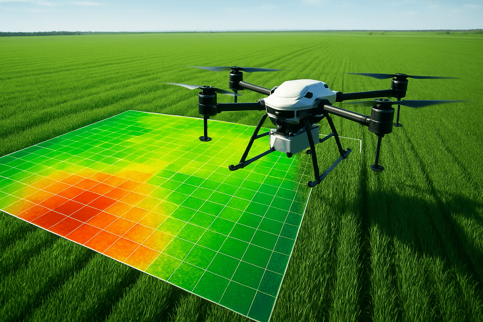
NDVI is a graphical indicator derived from remote sensing measurements, typically acquired from drones or satellites. It assesses the presence and condition of live green vegetation by analyzing the difference between near-infrared (NIR) and visible red light reflected by plants.
Healthy plants absorb a significant portion of visible light for photosynthesis while reflecting a large amount of NIR light. Stressed or unhealthy plants, on the other hand, absorb less visible light and reflect less NIR light. NDVI leverages this contrast to quantify vegetation health.
The NDVI value is calculated using the following formula:
NDVI = (NIR – Red) / (NIR + Red)
The resulting NDVI values range from -1 to +1:
- -1 to 0: Typically represents non-vegetated surfaces like water, bare soil, or built-up areas.
- 0 to +1: Indicates the presence of vegetation, with higher values signifying denser and healthier vegetation.
Why Use Drones for NDVI Photography?
While NDVI data can also be obtained from satellites, drones offer several key advantages:
- Higher Resolution: Drones capture imagery at much higher resolutions (centimeter-level) compared to satellites, enabling more detailed analysis of individual plants or specific areas within a field.
- Flexibility and Timeliness: Drones can be deployed quickly and easily, allowing for data collection at specific times and frequencies as needed. This is particularly important for monitoring rapidly changing conditions or time-sensitive events like disease outbreaks.
- Cost-Effectiveness: For smaller areas, drone-based NDVI surveys can be more cost-effective than satellite imagery, especially when frequent monitoring is required.
- Cloud Penetration: Drones can fly under cloud cover, whereas satellites are unable to capture images when there are clouds present.
- Complementary Data: Data collected by drones can compliment satellite data. When satellite data detects an area that may be problematic it can be inspected in more detail using a drone.
Applications of Drone NDVI Photography
Drone NDVI photography has a wide range of applications across various sectors:
1. Precision Agriculture
- Crop Health Monitoring: Identify areas of stress, disease, or pest infestation early on, even before visible symptoms appear. (AcuSpray, 2024)
- Optimizing Irrigation: Determine areas with water stress and tailor irrigation practices to conserve water and improve yields. (AcuSpray, 2024)
- Precision Fertilization: Assess nutrient deficiencies and adjust fertilizer application rates accordingly. (Dronefly)
- Yield Prediction: Estimate crop yields based on vegetation density and health. (Sentera, 2023)
- Variable Rate Application: Generate prescription maps for variable rate applicators, optimizing the use of fertilizers, pesticides, and herbicides. (Aerial Image Works)
- Soil Analysis: Drone photography can be instrumental at the start of the crop cycle as they produce precise 3-D maps for early soil analysis, useful in planning seed planting patterns. (Drones For Hire)
- Identify Soil Constraints: Identify soil constraints such as salt, shallow soil, and drainage issues. (Drones For Hire)
2. Land Management
- Vegetation Mapping: Identify and map different types of vegetation, land cover, and land use. (heliguy™, 2023)
- Change Detection: Monitor changes in land cover over time, such as urbanization, deforestation, and land degradation. (heliguy™, 2023)
- Invasive Species Mapping: Map the extent and distribution of invasive plant species for targeted control efforts. (MDPI, 2021)
- Natural Resource Management: Identify and map natural resources such as minerals and water. (heliguy™, 2023)
3. Environmental Monitoring
- Forest Health Assessment: Assess forest health, detect signs of stress or disease, and monitor reforestation efforts.
- Habitat Monitoring: Monitor the health and extent of natural habitats, such as wetlands and grasslands.
- Water Quality Monitoring: Assess water quality by analyzing the health of aquatic vegetation.
- Early Detection of Plant Stress: NDVI imaging can reveal stress in plants due to insufficient water, nutrient deficiencies, or disease before symptoms are visible to the human eye. (AcuSpray, 2024)
- Drought Monitoring: NDVI can be used to assess the impact of drought on vegetation.
Equipment and Workflow for Drone NDVI Photography
To conduct drone NDVI photography, you’ll need the following equipment and follow a specific workflow:
1. Drones
- Platform: Choose a drone platform that can carry the necessary sensors and offers sufficient flight time and stability. Popular options include DJI Matrice series, DJI Mavic 3 Multispectral, and custom-built drones.
- Relevant Experience: Ensure the drone operator has experience working with things like aerial data capture, handling windy days, knowing how and where to land, and using the appropriate algorithm for the crop at hand. (Drones For Hire)
2. Sensors
- NDVI Camera: An NDVI camera is a prerequisite which enables farmers to make the right decisions based on data; otherwise, all such information regarding crop health, soil conditions, and water management makes farming efficient and sustainable. (Dronefly)
- Multispectral Camera: A multispectral camera captures data across multiple narrow bands of the electromagnetic spectrum, including visible and near-infrared light. Examples include MicaSense RedEdge-P and Parrot Sequoia.
- Modified Camera: Convert a standard camera for NDVI vegetation and crop analysis. A traditional NDVI captures the red and infrared channel from which an index is generated to measure vegetation health. (Kolari Vision)
- RGB Camera: While not strictly an NDVI sensor, standard RGB (Red, Green, Blue) cameras can be used to calculate other vegetation indices like VARI (Visible Atmospherically Resistant Index) if a NIR camera is unavailable. (Coptrz, 2024)
- Gimbals: Equipping gimbals for mounted cameras or special attachments may add to the hourly or daily rate. (PhotoUp, 2025)
3. Software
- Flight Planning Software: Plan autonomous flight paths and control drone operations. Examples include DroneDeploy, Pix4Dcapture, and DJI GS Pro.
- Image Processing Software: Process raw imagery to generate orthomosaics and calculate NDVI values. Examples include Agisoft Metashape, Pix4Dmapper, DroneDeploy, and QGIS (with appropriate plugins).
- GIS Software: Integrate NDVI data with other geospatial information for analysis and decision-making. Examples include ArcGIS and QGIS.
- Multispectral Image Processing Tools: For agricultural applications, tools like Agremo and DroneDeploy offer solutions for processing multispectral drone imagery. (One3D, 2024)
- Free NDVI Processing Apps: Several free apps are available to process NDVI images such as the AgroCam NDVI camera.
4. Workflow Steps
- Mission Planning: Define the area of interest, desired flight altitude, image overlap, and ground resolution.
- Data Acquisition: Fly the drone along the planned flight path, capturing images at regular intervals. Ensure sufficient overlap (typically 70-80%) between images for accurate orthomosaic generation.
- Image Processing:
- Orthorectification: Correct geometric distortions in the images to create a geographically accurate orthomosaic.
- NDVI Calculation: Use image processing software to calculate NDVI values from the orthomosaic.
- Data Analysis:
- Visualization: Visualize NDVI data as a color-coded map, where different colors represent different levels of vegetation health.
- Interpretation: Analyze NDVI patterns to identify areas of concern or potential for improvement.
- Integration: Integrate NDVI data with other relevant information, such as soil maps, yield data, and weather patterns, to gain a more comprehensive understanding of the factors affecting vegetation health.
Factors to Consider
- Camera Quality: Ensure the drone with multispectral camera provides high-resolution imagery for accurate data analysis. (Dronefly)
- Flight Time & Range: A longer flight time and range mean more coverage and less downtime. (Dronefly)
- Safety Features: Look for drones with obstacle detection and other safety measures. (Dronefly)
- Software Compatibility: Ensure your drone and camera are compatible with mapping software for easy integration and data analysis.” (Dronefly)
Regulations and Safety
- UK Drone Laws: In the UK, drone operations are regulated by the Civil Aviation Authority (CAA). You must register as a drone operator and pass an online test to obtain a Flyer ID. (UK Civil Aviation Authority, 2025)
- Operational Authorization: For commercial operations or flights in restricted airspace, you may need to obtain an Operational Authorization from the CAA.
- Privacy: Respect people’s privacy. It’s against the law to take photographs or record video or sound for criminal or terrorist purposes. (UK Civil Aviation Authority)
- Visual Line of Sight: Keep the drone within visual line of sight at all times.
- No-Fly Zones: Be aware of no-fly zones, such as airports, military installations, and prisons.
- Weather Conditions: Do not fly in adverse weather conditions, such as strong winds or heavy rain.
Cost of Drone NDVI Photography
The cost of drone NDVI photography services can vary depending on several factors:
- Area Size: Larger areas will typically cost more to survey.
- Data Resolution: Higher resolution imagery requires more processing time and may increase costs.
- Data Analysis: Advanced data analysis and reporting will add to the overall cost.
- Location: Prices may vary depending on the location of the survey area.
- Photographer’s Experience: More experienced photographers with licensing and certifications typically charge more due to their expertise and compliance. (PhotoUp, 2025)
- Equipment Used: Advanced drones with higher resolution cameras and stabilizers lead to better quality but may raise prices. (PhotoUp, 2025)
Here’s a general pricing guideline for agricultural applications:
- Basic Aerial Mapping: Basic aerial mapping, which covers basic visual assessment, can range between $300 to $1,000 per flight. (PhotoUp, 2025)
- Advanced Aerial Mapping: Advanced mapping includes data analysis and specialized data products. This service can range between $1,000 to $1,300 per flight. (PhotoUp, 2025)
- Basic Crop Monitoring: Basic crop monitoring services include capturing images for crop health assessment. This service can range between $500 to $1500 per flight, though it may vary based on the area. (PhotoUp, 2025)
- Advanced Crop Monitoring: Advanced crop monitoring comes with data analysis. Including NDVI mapping and disease detection, the service can range between $1,500 and $5,000 per flight. (PhotoUp, 2025)
Conclusion
Drone NDVI photography is a valuable tool for monitoring vegetation health, optimizing resource allocation, and promoting sustainable practices in agriculture, land management, and environmental monitoring. By understanding the principles of NDVI, selecting the right equipment, and following a proper workflow, you can leverage this technology to gain valuable insights into the health and condition of our planet’s vegetation. As drone technology continues to advance, we can expect even more innovative applications of NDVI photography in the years to come.


