Drone telemetry is the automatic collection and transmission of data from a drone to a remote location, usually the operator’s ground control station (GCS). This data stream provides real-time insights into the drone’s performance, its environment, and the status of its various systems. Understanding drone telemetry is crucial for safe, efficient, and optimized drone operations across various applications.
What is Drone Telemetry?
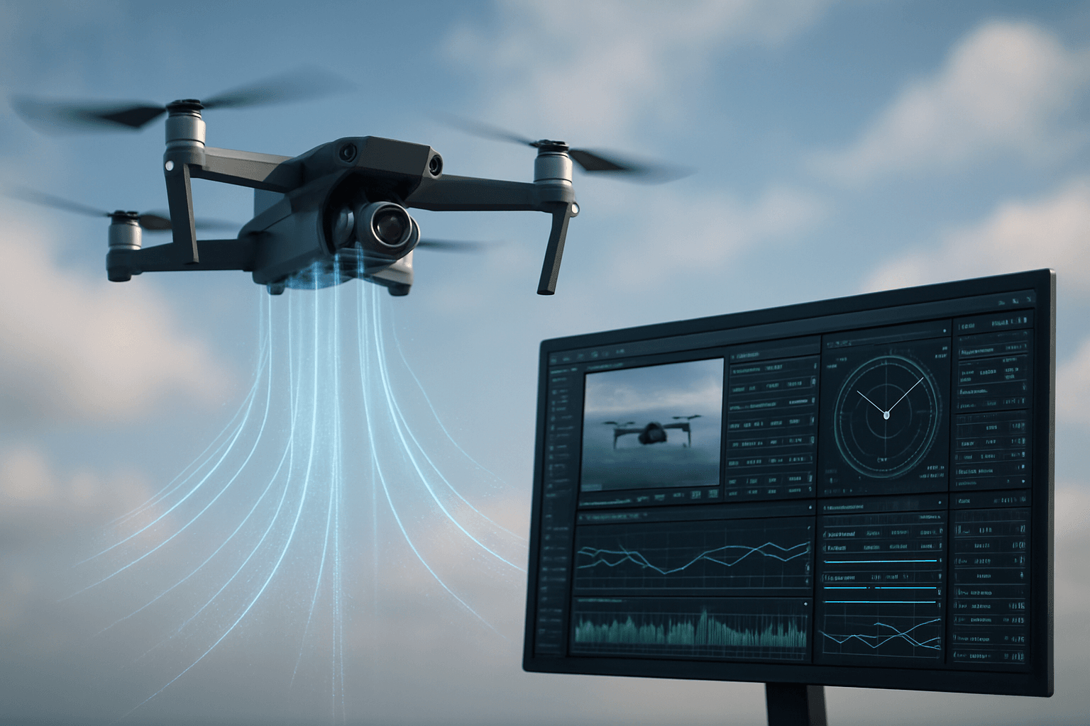
Telemetry, in the context of drones, involves gathering data about the aircraft and its surroundings and transmitting it back to the operator or GCS. This information is sourced from the drone’s autopilot, onboard sensors (like accelerometers, gyroscopes, and GPS), and subsystems such as the power source. Telemetry provides the ability to track a drone’s status in real time, allowing pilots to monitor position, attitude, and altitude to ensure smooth and efficient flight.
Key Aspects of Drone Telemetry:
- Real-Time Data Transmission: Telemetry data is transmitted live, providing an up-to-the-second view of the drone’s operation.
- Comprehensive Data Collection: A wide range of parameters are monitored, including flight data, sensor readings, and system status.
- Remote Monitoring: Operators can monitor the drone’s performance and location from a remote GCS.
- Enhanced Situational Awareness: Telemetry provides pilots with critical information for making informed decisions during flight.
- Post-Flight Analysis: Recorded telemetry data can be analyzed to optimize drone performance and investigate incidents.
The Importance of Drone Telemetry
Telemetry is essential for several reasons:
- Safety: Real-time data allows operators to identify and respond to potential issues before they escalate into critical failures.
- Efficiency: Monitoring parameters like battery life and motor performance helps optimize flight paths and mission parameters.
- Compliance: In many regions, regulations require drones to maintain a reliable telemetry link for safe operation.
- Data Analysis: Telemetry data is valuable for post-flight analysis, performance optimization, and accident investigation.
- Situational Awareness: Telemetry provides pilots with a comprehensive understanding of the drone’s state and its surrounding environment.
Types of Data Provided by Drone Telemetry
Drone telemetry systems collect and transmit a wide variety of data, which can be broadly categorized as follows:
Flight Data:
- Altitude: Height above ground level.
- Airspeed: The drone’s speed through the air.
- Ground Speed: The drone’s speed relative to the ground.
- Position: GPS coordinates (latitude and longitude).
- Orientation: Attitude (pitch, roll, yaw) of the drone.
- Flight Mode: Current operational mode (e.g., loiter, autonomous, manual).
Sensor Data:
- Battery Voltage and Current: Remaining battery capacity and power consumption.
- Motor RPM: Rotations per minute of each motor.
- Temperature: Temperature readings from various components.
- Vibration Levels: Measures of mechanical vibration.
- Environmental Data: Data from sensors such as barometers, accelerometers, gyroscopes, magnetometers, and time-of-flight sensors.
System Status:
- Error Messages: Notifications of any system faults or warnings.
- Signal Strength: Strength of the communication link between the drone and the GCS.
- Component Health: Status of critical components, such as the flight controller and GPS module.
- Payload Data: Data from any specialized payloads, such as cameras or sensors.
How Drone Telemetry Works
The drone telemetry process involves several key components working together:
- Sensors: Various sensors on the drone collect data about its state and environment.
- Flight Controller: The flight controller processes the data from the sensors and prepares it for transmission.
- Telemetry Module: A telemetry module encodes the data and transmits it wirelessly to the GCS.
- Communication Link: Data is transmitted via radio frequencies, Wi-Fi, or cellular networks.
- Ground Control Station (GCS): The GCS receives, decodes, and displays the telemetry data for the operator.
Communication Technologies
Telemetry data is transmitted wirelessly using various communication technologies:
- Radio Frequency (RF): Common frequencies include 433 MHz, 915 MHz, and 2.4 GHz.
- Wi-Fi: Suitable for shorter-range applications.
- Cellular Networks (4G/5G): Enable long-range telemetry transmission.
- Satellite Communication: Used for very long-range or beyond visual line of sight (BVLOS) operations.
Applications of Drone Telemetry
Drone telemetry has a wide range of applications across various industries:
- Delivery Services: Monitoring package location, drone health, and delivery status.
- Infrastructure Inspection: Collecting data on the condition of power lines, bridges, and other critical infrastructure.
- Agriculture: Monitoring crop health, irrigation, and livestock.
- Law Enforcement: Providing real-time situational awareness during police operations.
- Search and Rescue: Locating missing persons and assessing disaster areas.
- Environmental Monitoring: Collecting data on air quality, wildlife populations, and environmental changes.
- Wildlife Tracking: Tracking tagged animals in real-time across vast terrains.
- Accident Analysis: Analyzing flight data and video to determine the cause of drone incidents.
Benefits of Using Drone Telemetry
Implementing drone telemetry offers numerous advantages:
- Improved Safety: Real-time monitoring enables proactive responses to potential hazards.
- Enhanced Efficiency: Optimizing flight parameters and resource usage improves operational efficiency.
- Data-Driven Decision Making: Access to comprehensive data empowers informed decision-making.
- Regulatory Compliance: Meeting regulatory requirements for drone operations ensures legal compliance.
- Cost Savings: Preventing accidents and optimizing performance reduces operational costs.
Challenges and Considerations
While drone telemetry offers significant benefits, there are also challenges and considerations to keep in mind:
- Data Security: Protecting telemetry data from unauthorized access and manipulation is crucial.
- Bandwidth Limitations: Transmitting large volumes of data in real-time can strain bandwidth capacity.
- Integration Complexity: Integrating telemetry systems with existing drone platforms and GCS can be complex.
- Regulatory Restrictions: Regulations regarding data privacy and transmission may vary by region.
- Computational Resources: Processing and analyzing telemetry data requires sufficient computing power.
- Maintaining VLOS: UK regulations emphasize the importance of maintaining visual line of sight, with telemetry not being an acceptable substitute for direct visual observation.
Drone Telemetry in the UK: Regulations and Guidelines
In the UK, drone operations are regulated by the Civil Aviation Authority (CAA), and compliance with these regulations is mandatory. Here are some key points to consider regarding drone telemetry in the UK:
- CAA Regulations: The CAA sets the rules for how and under what conditions drones may be operated, including requirements for telemetry and data transmission.
- Visual Line of Sight (VLOS): UK regulations emphasize the importance of maintaining VLOS during drone operations.
- Radio Spectrum: Ofcom, the spectrum regulator in the UK, authorizes the use of radio communication equipment on drones.
- Licensing: A UAS Operator Radio Licence may be required for certain drone operations, particularly those beyond visual line of sight (BVLOS).
- Data Privacy: Operators must comply with data protection laws when collecting and transmitting telemetry data.
- Operational Authorization: For flights within the “Specific” category (riskier operations), an operational authorization issued by the CAA is required.
Visual Line of Sight (VLOS) Explained
VLOS is a critical concept for drone pilots in the UK. It means that the remote pilot must maintain direct, unaided visual contact with the drone throughout the flight. While telemetry can provide valuable information about the drone’s status, it cannot be used as a substitute for VLOS.
According to the CAA, to maintain VLOS, the remote pilot must:
- Control the visual flight path of the drone.
- Keep the drone within a suitable distance to monitor its position, orientation, and surrounding airspace at all times.
- Be able to visually determine the aircraft’s orientation without relying solely on telemetry.
Factors affecting VLOS include the pilot’s eyesight, drone size, weather conditions, and terrain.
Radio Spectrum and Licensing
In the UK, Ofcom regulates the use of radio communication equipment, including that used for drone telemetry. Most drones currently use spectrum designated for Wi-Fi or model aircraft, which does not require a license. However, for longer-range operations, a UAS Operator Radio Licence may be necessary. This license authorizes the use of radio equipment on drones and enables BVLOS operations.
Future Trends in Drone Telemetry
The field of drone telemetry is constantly evolving, with several exciting trends on the horizon:
- Enhanced Data Analytics: Advanced algorithms and machine learning techniques will enable more sophisticated analysis of telemetry data.
- Improved Communication Links: New communication technologies, such as 5G and satellite communication, will provide more reliable and higher-bandwidth telemetry links.
- Edge Computing: Processing telemetry data on the drone itself (edge computing) will reduce latency and bandwidth requirements.
- Artificial Intelligence (AI): AI-powered systems will use telemetry data to enable autonomous flight and decision-making.
- Increased Security: Advanced encryption and security measures will protect telemetry data from cyber threats.
Conclusion
Drone telemetry is a vital technology that provides real-time insights into drone operations, enhancing safety, efficiency, and decision-making. By understanding the principles and applications of drone telemetry, operators can unlock the full potential of this technology and ensure safe and successful drone missions. As drone technology continues to advance, telemetry will play an increasingly important role in enabling new and innovative applications across various industries.


