Tunnel inspection has historically been a challenging, labor-intensive, and often hazardous undertaking, requiring human inspectors to navigate confined, dark, and potentially dangerous environments. Traditional methods often involve extensive scaffolding, traffic disruptions, and prolonged downtimes, making the process costly and inefficient. However, the advent of Unmanned Aerial Systems (UAS), commonly known as drones, is revolutionizing how these critical infrastructure assets are assessed. Drones offer a safer, faster, and more cost-effective alternative, delivering high-quality, comprehensive data that was once difficult to obtain.
This guide delves into the specifics of conducting a drone survey for tunnel inspection, outlining the benefits, essential technologies, step-by-step processes, and common challenges.
Why Drones for Tunnel Inspection? Unlocking Efficiency and Safety
The advantages of deploying drones for tunnel inspection are compelling, addressing many drawbacks of conventional methods:
Enhanced Safety
One of the most significant benefits is the drastic reduction in human risk. Drones eliminate the need for personnel to enter hazardous or difficult-to-reach areas, such as those with poor air quality, structural instabilities, or confined spaces. This not only protects inspectors but also reduces liability and potentially lowers insurance costs.
Increased Efficiency and Speed
Drones can cover vast distances and complex geometries much faster than manual inspections. What once took days or weeks can now be completed in hours, minimizing project delays and allowing for more frequent monitoring. For example, drone inspections have been reported to cut inspection times by as much as 50% for transportation tunnels and even halve inspection times in water and utility tunnels.
Cost-Effectiveness
By reducing the need for extensive labor, scaffolding, lifts, and heavy machinery, drones significantly cut operational expenses. Some reports indicate cost reductions of up to 50% for surveying expenses, and in some instances of confined space inspections, internal inspection costs have been slashed by as much as 90%. Furthermore, faster inspections mean less traffic disruption, saving additional indirect costs.
High-Quality, Comprehensive Data
Equipped with advanced sensors, drones capture high-resolution visual, thermal, and 3D data. This enables the creation of detailed 3D models and point clouds, allowing for precise identification of cracks, corrosion, water leaks, structural anomalies, and deformations that might be missed by the human eye. This data provides a comprehensive view of the tunnel’s condition and can be used for long-term asset management and predictive maintenance.
Key Technologies for Tunnel Inspection Drones
Successful drone tunnel inspections rely on a suite of specialized technologies to overcome the unique challenges of underground environments:
GPS-Denied Navigation
Tunnels are GPS-denied environments, meaning standard satellite navigation systems are ineffective. To overcome this, drones utilize:
- Simultaneous Localization and Mapping (SLAM): This critical technology allows drones to create a map of an unknown environment while simultaneously tracking their own position within it. SLAM integrates data from multiple onboard sensors, including LiDAR, visual cameras, and Inertial Measurement Units (IMUs). SLAM is particularly advantageous in dark tunnel environments as it doesn’t rely on lighting conditions like photogrammetry.
- Inertial Navigation Systems (INS): These systems use gyroscopes and accelerometers to track movement and orientation, complementing SLAM by providing crucial data when other sensors face limitations.
- Visual Odometry and Computer Vision Algorithms: These enhance navigation by processing visual data to detect obstacles and refine the drone’s path in real time.
- Ultrasonic Positioning: Some drones also incorporate ultrasonic sensors for precise positioning in confined spaces.
Advanced Sensors for Data Capture
- LiDAR (Light Detection and Ranging): A standout tool for monitoring tunnel deformations, LiDAR emits laser pulses to measure distances and generate highly detailed 3D point clouds. This provides precise mapping of tunnel surfaces and is crucial for detecting subtle changes and creating digital twins. LiDAR is effective even in low-light conditions.
- Photogrammetry: By capturing overlapping high-resolution photographs, photogrammetry creates detailed 3D models and orthomosaics of the tunnel structure. When combined with LiDAR, it can achieve centimeter-level accuracy.
- Thermal Imaging: Thermal cameras can detect anomalies such as temperature fluctuations, water ingress, or early signs of structural degradation that might not be visible to the naked eye.
- Gas Detection Sensors: For tunnels with potential air quality concerns, such as utility tunnels or those connected to industrial sites, gas detection sensors can provide real-time data on hazardous fumes, ensuring safety for both operations and future maintenance.
Collision Tolerance
Operating in confined and complex tunnel environments significantly increases the risk of collisions. Specialized drones are designed with protective cages or collision-tolerant frames that allow them to make contact with surfaces without sustaining damage or crashing. This design is crucial for reliable operation where sense-and-avoid technology alone might be insufficient.
The Drone Tunnel Inspection Process: Step-by-Step
Conducting a successful drone survey for tunnel inspection involves several critical stages:
1. Pre-Flight Planning and Risk Assessment
This is the most crucial step for a safe and effective mission.
- Define Inspection Goals: Clearly outline what needs to be inspected (e.g., structural integrity, water leaks, specific defect mapping) and the desired data output (e.g., visual imagery, 3D point cloud, thermal maps).
- Site Assessment: Thoroughly survey the tunnel and its surroundings. Identify potential hazards like protruding objects, varying lighting conditions, dust, water flow, and tight corners. Understand the tunnel’s length, bends, and any specific structural features.
- Choose the Right Drone and Payload: Select a drone specifically designed for confined spaces, ideally with collision tolerance and GPS-denied navigation capabilities (like SLAM-enabled systems). Equip it with the necessary sensors (LiDAR, high-resolution RGB, thermal, gas detectors) to meet the inspection objectives. Consider battery life and payload capacity.
- Develop a Detailed Flight Plan: Map out a systematic flight path to ensure complete data coverage and minimize the risk of missed areas or collisions. This may involve grid patterns or following the tunnel’s contours. Specify altitude, speed, and any points of interest for closer examination.
- Regulatory Compliance: Check local aviation laws and obtain any necessary permits or authorizations, especially for operating in controlled airspace or sensitive infrastructure. Ensure pilots are trained and certified for drone operations, particularly in complex environments.
2. Equipment Setup and Pre-Flight Checks
Before deployment, rigorous checks are essential.
- Charge and Install Batteries: Ensure all drone and controller batteries are fully charged, and carry spares for longer inspections.
- Sensor Calibration and Settings: Calibrate all sensors (cameras, LiDAR) and adjust settings (exposure, focus, resolution, white balance) for optimal data quality in the tunnel’s challenging conditions, particularly low light.
- Communication Setup: Verify a stable communication link between the drone and the operator. In long tunnels, signal repeaters or tethered drone systems may be necessary to maintain connection. Tethered systems can also provide continuous power.
- Physical Inspection: Perform a physical inspection of the drone for any damage, ensuring propellers are secure, and all components are functioning correctly.
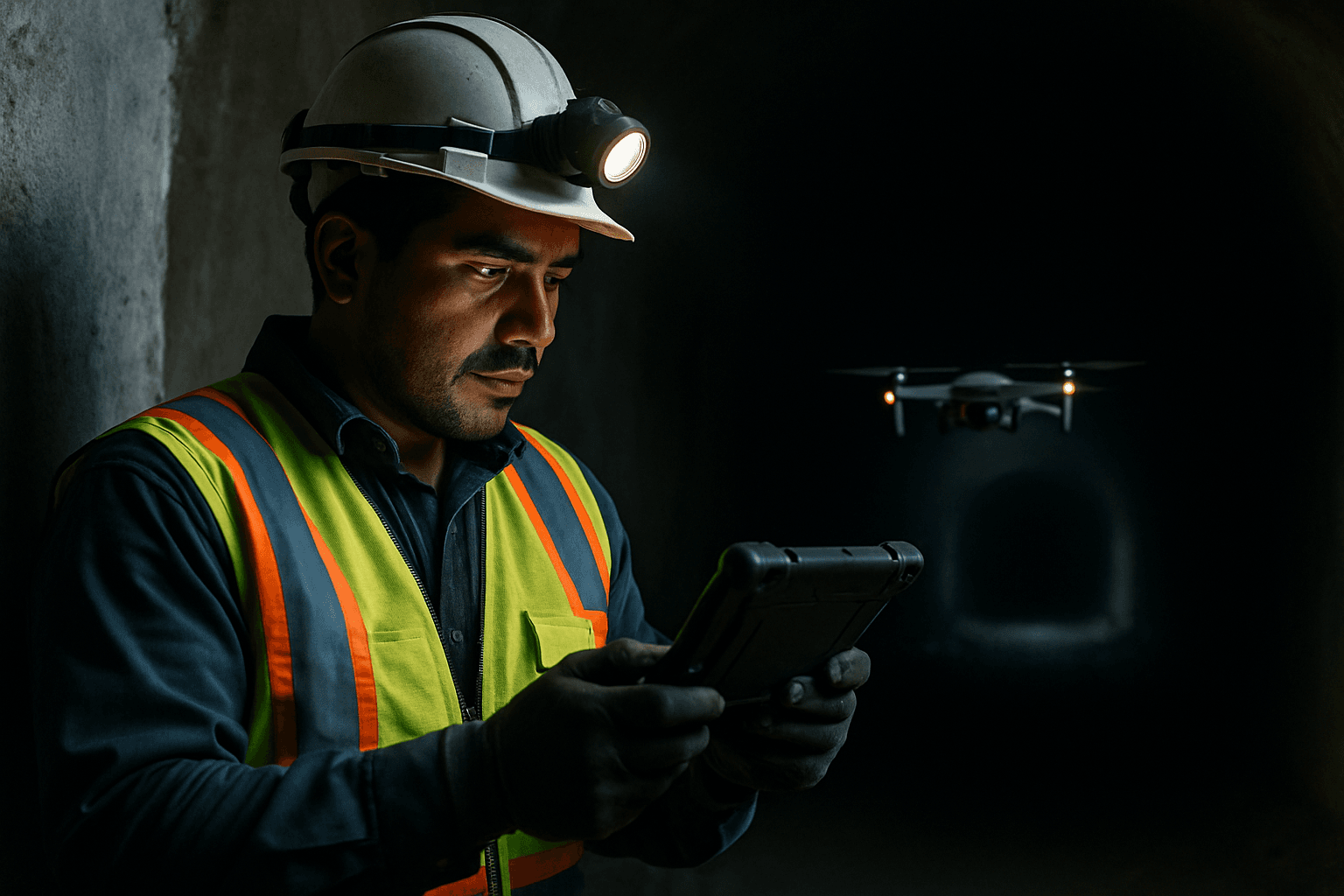
3. Executing the Drone Flight
- Maintain Visual Line of Sight (VLOS): Whenever possible and legally required, the operator should maintain VLOS with the drone. However, in long or winding tunnels, this is often not feasible, necessitating advanced autonomous capabilities or a spotter at the other end.
- Systematic Data Capture: Follow the pre-planned flight path diligently, ensuring steady flight for consistent data quality. Drones with 3-axis gimbals are essential for stable imagery.
- Real-time Monitoring: Monitor the drone’s telemetry and sensor feed in real-time. This allows operators to make immediate adjustments if obstacles are encountered or if data quality appears compromised.
- Adapt to Conditions: Be prepared to adjust flight parameters if unexpected conditions like heavy dust, water, or unforeseen obstacles arise.
4. Post-Flight Data Processing and Analysis
The raw data collected by the drone is transformed into actionable insights.
- Data Processing Software: Use specialized software for photogrammetry (e.g., Pix4D, Agisoft Metashape, DroneDeploy) and LiDAR point cloud processing (e.g., Emesent software, CloudCompare). This software stitches images, creates 3D models, and generates precise point clouds.
- Generating Deliverables: Produce high-definition 2D and 3D maps, orthomosaics, 3D point clouds, and comprehensive inspection reports.
- Defect Detection and Analysis: Analyze the processed data to identify structural issues like cracks, spalling, water infiltration, and deformation. Artificial intelligence (AI) and machine learning (ML) algorithms are increasingly used to automate defect detection, making the analysis faster and more objective.
- Data Management and Archiving: Store the collected data and reports digitally for future reference, comparative analysis, and long-term asset management.
Challenges in Drone Tunnel Surveys
Despite the numerous benefits, drone tunnel inspections present specific challenges:
- GPS-Denied Navigation: As mentioned, the absence of GPS signals requires sophisticated navigation systems like SLAM, IMUs, and visual odometry.
- Limited Battery Life: Constant maneuvering and powering multiple sensors in confined spaces can quickly drain drone batteries, necessitating efficient power management, multiple battery swaps, or tethered systems.
- Signal Interference and Communication Loss: Thick tunnel walls, metal structures, and other obstacles can disrupt communication signals between the drone and the operator, risking loss of control. High-frequency, low-interference communication systems and signal repeaters can help mitigate this.
- Dust, Darkness, and Humidity: Tunnels often have poor lighting, dust, and high humidity, which can affect sensor performance and image quality. Drones need powerful integrated lighting, and sensors like LiDAR are less affected by darkness.
- Obstacle Avoidance in Tight Spaces: Navigating tight corners and avoiding unexpected protrusions requires highly agile drones, advanced obstacle avoidance technology, and often collision-tolerant designs.
The Future of Drone Tunnel Inspections
The field of drone-based tunnel inspection is rapidly evolving. Expect to see continued advancements in:
- Increased Automation and AI: More autonomous drones capable of navigating complex tunnel networks with minimal human intervention, coupled with AI-powered data analysis for faster and more accurate defect detection.
- More Robust and Specialized Hardware: Drones will become even more rugged, with improved battery life, enhanced sensor integration, and designs specifically optimized for extremely harsh or unique tunnel environments.
- Integration with Digital Twins: Real-time data collected by drones will feed directly into digital twin models of tunnels, providing continuously updated, comprehensive virtual replicas for predictive maintenance and lifecycle management.
By embracing these sophisticated UAS technologies and adhering to best practices, organizations can ensure safer, more efficient, and highly accurate tunnel inspections, ultimately contributing to the longevity and safety of critical infrastructure.


