Imagine a world where the most dangerous and elusive secrets of our atmosphere, from the churning heart of a hurricane to the invisible dance of greenhouse gases, were no longer beyond our grasp. For decades, scientists relied on a patchwork of ground stations, sporadic weather balloons, and prohibitively expensive manned aircraft to piece together the atmospheric puzzle. Today, a new class of agile, intelligent, and remarkably persistent aerial vehicles—drones—are not just augmenting these traditional methods; they are fundamentally reshaping our ability to observe, understand, and predict the complex dynamics of the air that sustains us.
Unprecedented Access and Data Acquisition
One of the most significant advantages of deploying unmanned aerial vehicles (UAVs) in atmospheric research is their ability to reach environments that are often inaccessible or too hazardous for human-crewed aircraft or ground-based equipment. This expanded access is crucial for gathering critical data in previously unobservable conditions.
Reaching Hazardous and Remote Environments
Drones can safely penetrate the core of severe weather phenomena, such as hurricanes, typhoons, and tornadoes, allowing scientists to collect vital real-time data on wind speed, temperature, and humidity directly from within the storm’s structure. This direct measurement capability is far safer and more practical than sending manned aircraft into such perilous conditions. Beyond extreme weather, drones provide unparalleled access to remote or difficult-to-reach geographical areas, including mountainous regions, polar ice caps like Antarctica, and industrial zones, where traditional monitoring methods are impractical or impossible to deploy. For instance, they can safely inspect emissions from industrial chimneys and vents or gather data from active volcanic plumes without risking human lives.
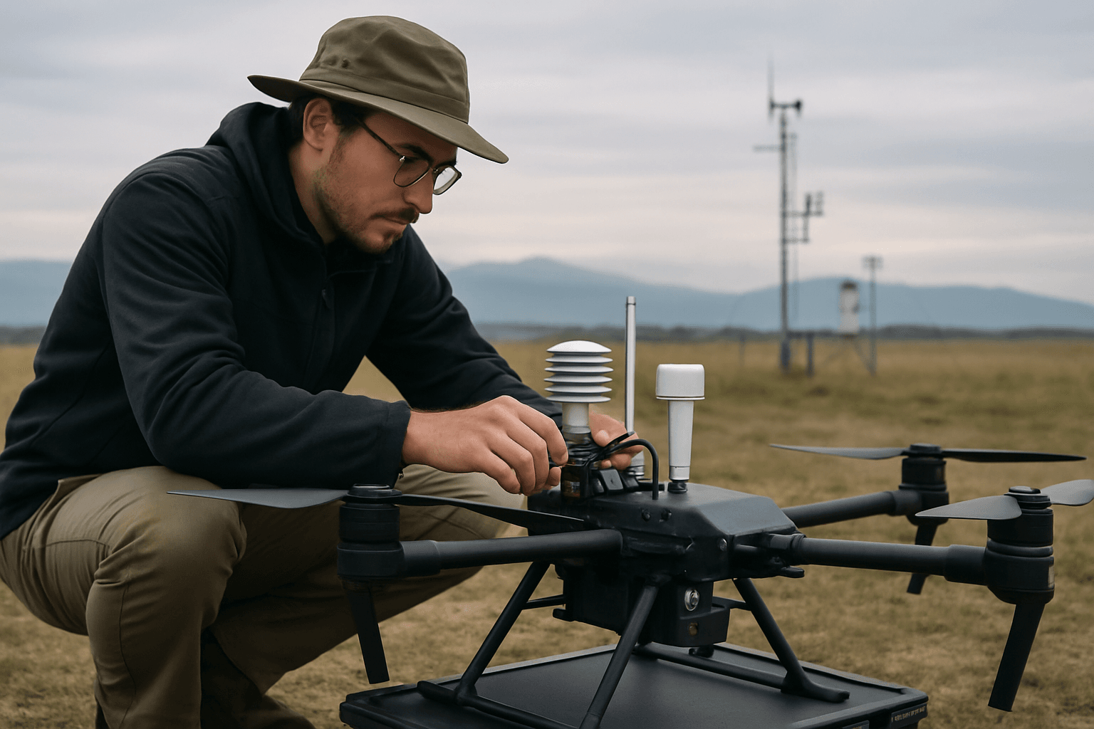
High-Resolution and Multi-Dimensional Data Collection
Unlike stationary sensors or weather balloons that offer limited spatial or temporal resolution, drones can traverse various altitudes and locations, providing a dynamic, high-resolution, and multi-dimensional view of atmospheric conditions. This flexibility enables the collection of detailed vertical profiles of atmospheric parameters, which is vital for understanding phenomena like the planetary boundary layer – the lowest part of the atmosphere where human activities have the most direct impact. They can measure temperature, humidity, wind speed and direction, atmospheric pressure, and concentrations of various gases and aerosols with exceptional precision and accuracy, often with a resolution thousands of times denser than traditional methods.
Real-Time Data for Immediate Insights
Equipped with advanced sensors, drones can transmit real-time data on atmospheric conditions, including pollutant levels and meteorological parameters. This immediate data stream is invaluable for a variety of applications, from improving the accuracy of weather prediction models and providing earlier warnings for severe weather events to enabling rapid response in air pollution emergencies or disaster management scenarios.
Enhanced Efficiency and Cost-Effectiveness
Beyond their data collection capabilities, drones offer significant operational and economic advantages over conventional atmospheric research methods, making long-term monitoring and extensive field campaigns more feasible.
Reduced Costs and Increased Efficiency
The deployment and operation of drones are generally more cost-effective and sustainable than traditional methods such as manned aircraft or single-use weather balloons, which can be expensive to operate and often lead to equipment loss. Drones require less personnel, fuel, and logistical support, reducing labor costs and overall project expenses. Their ability to cover large areas quickly and perform automated flight paths significantly boosts efficiency, freeing up human resources for higher-value tasks like data analysis and interpretation.
Rapid Deployment and Reusability
Drones can be deployed quickly in response to changing weather conditions or specific research needs, offering unparalleled flexibility. Unlike single-use weather balloons, drones are reusable platforms that can be deployed repeatedly, making long-term monitoring and extensive field campaigns more economically viable and environmentally friendly. This reusability also minimizes waste and the consumption of resources like helium, which is often used for balloons.
Diverse Applications in Atmospheric Science
The versatility of drones allows for a wide array of applications across different facets of atmospheric research, providing critical insights into weather, climate, and environmental health.
Advancing Weather Forecasting and Severe Storm Research
Drones are revolutionizing weather forecasting by providing high-resolution data from the atmospheric boundary layer, a region traditionally under-observed but critical for local weather prediction. This data helps improve the accuracy and reliability of forecasts, particularly for hard-to-predict phenomena like thunderstorms, strong winds, and fog. Large high-altitude drones like NASA’s Global Hawk have been instrumental in studying the formation and intensification of hurricanes, contributing to better early warning systems. Furthermore, low-flying drones provide high-resolution photographs to assess and document wind and flood damage after severe weather events, helping to estimate storm intensity and aid disaster response.
Comprehensive Air Quality and Pollution Monitoring
One of the most impactful applications of drones is in monitoring air quality and detecting pollution. Equipped with specialized sensors, drones can measure a wide range of pollutants, including carbon dioxide (CO2), sulfur dioxide (SO2), nitrogen oxides (NOx), particulate matter (PM2.5 and PM10), volatile organic compounds (VOCs), methane (CH4), and ozone (O3). They can create real-time, 2D and 3D pollution maps across urban areas, industrial sites, and natural landscapes, allowing researchers to identify pollution hotspots, track pollutant dispersion patterns, and pinpoint emission sources with unprecedented accuracy. This capability is crucial for public health initiatives, environmental impact assessments, and ensuring compliance with environmental regulations.
Contributing to Climate Change and Atmospheric Composition Studies
Drones play a vital role in enhancing our understanding of climate change by collecting data on atmospheric conditions such as temperature, gas composition, and aerosol concentrations. They can identify and quantify fugitive trace gas fluxes, helping to discriminate the contributions of various processes to greenhouse gas emissions and refine global carbon cycle models. For example, drones equipped with gas sensors have provided the first direct CO2 readings at active volcanoes, revealing their significant contribution to carbon emissions. By sampling in different atmospheric layers, drones provide unique information about methane sources, which is critical for improving climate models and developing policies to reduce emissions.
Investigating Atmospheric Electricity and Cloud Processes
The Earth’s atmosphere is an electrically charged environment, and drones are ushering in a new era for studying atmospheric electricity phenomena. They offer unprecedented capabilities for investigating complex processes like cloud electrification and aerosol interactions, which influence droplet size, concentration, and ultimately precipitation processes. Scientists can instrument drones to release positive or negative ions on demand and study their impact on cloud properties, potentially aiding rainfall in water-stressed regions.
Synergistic Integration with Emerging Technologies
The true potential of drones in atmospheric research is further amplified when they are integrated with other advanced technologies.
Artificial Intelligence and Machine Learning
The combination of drones with Artificial Intelligence (AI) and Machine Learning (ML) systems creates an even more powerful research tool. AI can analyze the vast datasets gathered by drones, identify complex patterns, and generate predictions, significantly enhancing the accuracy and utility of the collected information. ML models can be trained to improve weather forecasting accuracy, identify subtle changes in atmospheric composition, and even predict the behavior of storms.
IoT and Big Data Analytics
The integration of drones with the Internet of Things (IoT) and big data analytics allows for seamless, real-time data collection, processing, and visualization. This connectivity empowers researchers to monitor and assess atmospheric operations more effectively, unlocking new opportunities for efficiency and productivity in scientific endeavors. The comprehensive data sets collected by drone swarms, for instance, can provide a more holistic understanding of atmospheric systems than individual measurements.
The increasing availability and reliability of drone platforms continue to open new avenues in the study of the planetary boundary layer and the complex interactions between the Earth’s surface and atmosphere. While challenges remain, such as regulatory hurdles and sensor limitations, the benefits of using drones for atmospheric research are undeniable. They represent a transformative leap forward in our quest to understand and respond to the critical dynamics of our planet’s atmosphere.


