In the perilous landscape of chemical, biological, radiological, nuclear, and explosive (CBRNE) incidents, traditional search and rescue (SAR) operations expose human responders to immense risks. The need for rapid, accurate, and remote assessment is paramount. Unmanned Aerial Systems (UAS), commonly known as drones, equipped with specialized payloads, are emerging as a transformative solution, revolutionizing how emergency services detect, identify, monitor, and respond to these grave threats. By extending the reach and enhancing the safety of first responders, drone payload integration for CBRNE SAR offers unparalleled capabilities in hazardous environments.
The Critical Role of Drones in CBRNE Search and Rescue
CBRNE incidents present unique challenges due to their inherent dangers, which can include toxic gases, invisible radiation, and unstable explosive materials. Human entry into such “hot zones” requires extensive protective equipment and carries significant health risks, often delaying critical information gathering. This is where drones prove invaluable.
Integrating CBRNE sensors with UAS provides the ability to remotely detect, identify, and monitor hazardous substances, supplying crucial real-time information in emergency scenarios. This remote capability allows first responders to maintain a safe standoff distance, drastically limiting their exposure to harmful agents. Drones can access hard-to-reach or unsafe areas, such as burning buildings, contaminated sites, or rugged terrain, far more rapidly and safely than human teams. This speed of deployment and data collection is critical for faster decision-making, enhancing overall situational awareness for incident commanders.
Specialized Drone Payloads for CBRNE Detection
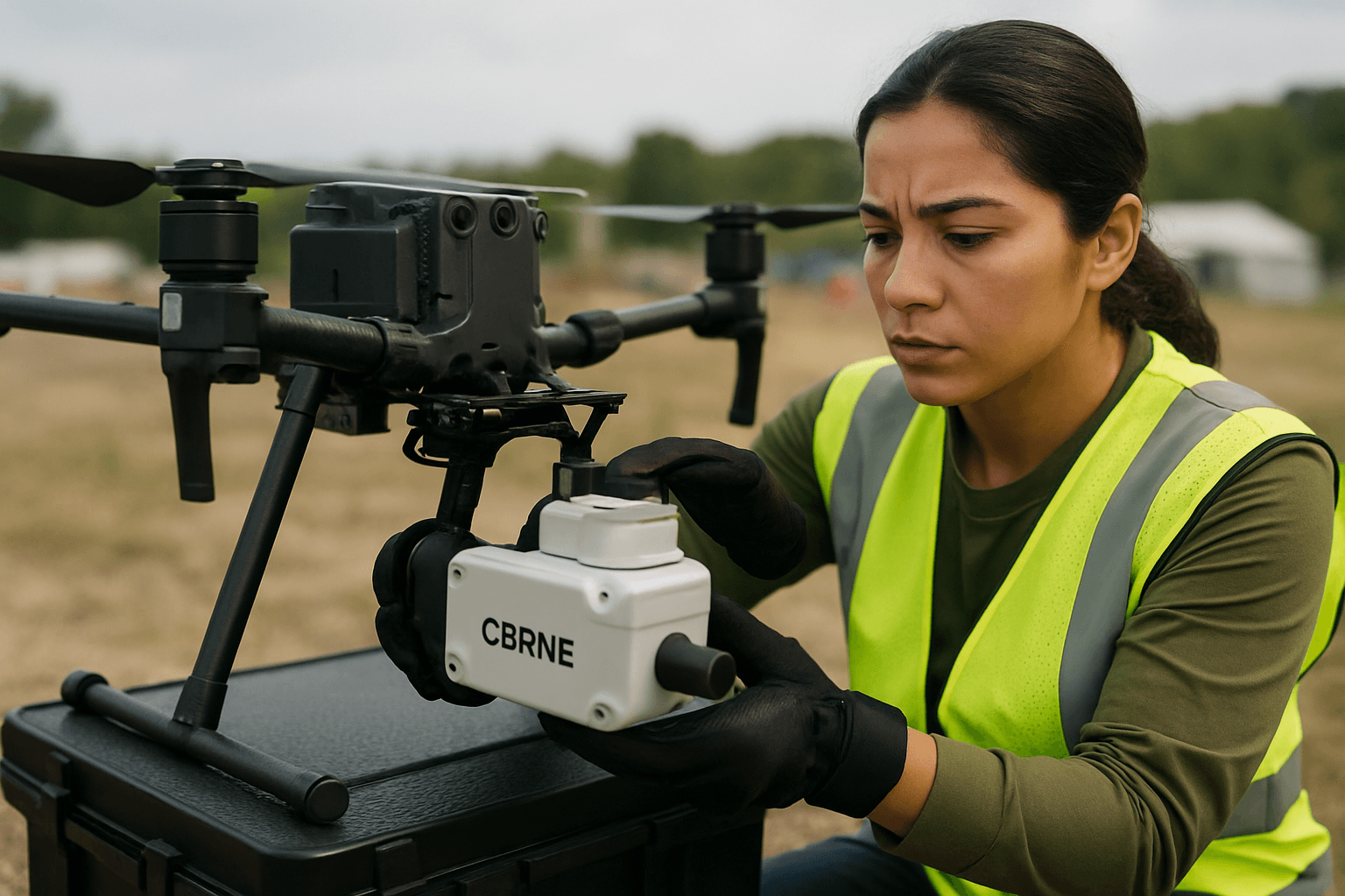
The effectiveness of a drone in CBRNE SAR hinges on its integrated payloads – the specialized sensors and equipment it carries. Advances in miniaturization and sensor technology have led to a diverse array of payloads capable of detecting the full spectrum of CBRNE threats.
Chemical and Gas Detection Payloads
For chemical threats, drones can carry a variety of advanced sensors designed to detect and analyze airborne hazardous materials. These include:
- Photo-ionization Detectors (PIDs) and Electrochemical Sensors: Used to detect volatile organic compounds (VOCs) and specific toxic industrial compounds (TICs) or gases like carbon monoxide (CO), hydrogen sulfide (H2S), chlorine (Cl2), and ammonia (NH3). Some systems can even detect methane and diesel fumes.
- Multi-gas Detectors: Compact systems, like Teledyne FLIR’s MUVE C360, can provide real-time continuous monitoring of various chemical hazards.
- Air Sample Collection: Drones can be equipped with probes to collect air samples for later laboratory analysis, providing definitive identification of unknown substances. The efficiency of gas detection can sometimes be improved when the UAV is very close to ground level with rotors on, affecting air flow.
Biological Agent Detection Payloads
Identifying biological threats, such as deadly biological agents or airborne biohazards like anthrax and nerve gas aerosols, is another critical application. Drones can be fitted with:
- Bio-aerosol Detectors: Specialized sensors, such as the Teledyne FLIR MUVE B330, are purpose-built to detect the presence of biological agents in the air, offering early warning capabilities.
- Particle Counters and Samplers: These payloads can collect airborne particles for subsequent analysis, helping to identify biological contaminants.
Radiological and Nuclear Detection Payloads
Detecting and mapping radiation is a high-priority task in nuclear and radiological incidents. Drone-based systems excel here by keeping personnel out of direct exposure.
- Radiation Detectors: Payloads like the Teledyne FLIR MUVE R430 are advanced radiation detectors designed for UAS to detect, locate, measure, map, and identify radioactive sources (alpha, beta, gamma, and neutron radiation) from above.
- Contamination Mapping Systems: Companies like Kromek offer systems such as AARM, which, when mounted on multirotor drones, can conduct rapid, detailed radiological surveys, creating metre-resolution radiation heat maps in real-time. This often involves the integration of LiDAR technology to automatically correct radiation data for varying flight heights, allowing for accurate dose calculations.
- Isotope Identification: Advanced payloads can differentiate between various types of radiation, providing detailed information about the radiological environment and identifying specific radioisotopes present.
Explosive Detection Payloads
For explosive threats, drones offer a safe standoff distance for investigation.
- Standoff Raman Sensors: Specialized payloads, such as the deep ultraviolet standoff Raman sensor, can detect explosive and other hazardous materials from distances of up to five kilometers by analyzing scattered light from an object.
- Laser Spectrometry Systems: Companies like Laser Detect Systems (LDS) have developed “sniffer drones,” such as SpectroDrone, which uses laser spectrometry to remotely identify explosives and hazardous materials.
General Situational Awareness Payloads
Beyond specific CBRNE detectors, several payloads enhance overall SAR capabilities:
- Electro-Optical/Infrared (EO/IR) Cameras: These multi-sensor systems provide both visual (daylight) and thermal imaging capabilities. Thermal cameras, like the DJI Zenmuse H20T, are crucial for detecting body heat in low-visibility conditions (darkness, smoke, dense foliage), significantly reducing search times.
- LiDAR and Photogrammetry Payloads: These are used to quickly generate high-resolution 2D maps and 3D models of disaster zones, collapsed buildings, or complex terrain, aiding in navigation and assessment for ground teams.
- Laser Rangefinders: Integrated with cameras, these provide precise coordinates of detected subjects or hazards, enabling accurate targeting for ground teams.
- Communication Relays: Drones can carry communication modules to establish or restore radio and data links in areas where infrastructure is compromised, improving team coordination.
Challenges and Considerations for Payload Integration
Successfully integrating CBRNE payloads onto drones involves overcoming several engineering and operational challenges:
Weight, Size, and Power Constraints
The limited payload capacity of small UAS (sUAS, typically under 25 kg) necessitates lightweight, low-power instrumentation. Every additional gram and watt consumed directly impacts flight time, stability, and maneuverability. Designers must optimize sensors for minimal size, weight, and power (SWaP) while maintaining detection capabilities.
Mechanical and Electrical Integration
Physical attachment points, mounts, casings, wire harnessing, and cable chargers must be compatible between the drone and the sensor. Poor integration can lead to uneven weight distribution, affecting the drone’s flight performance. Ideally, payloads are designed for “plug-and-play” integration, allowing quick swapping of sensors based on mission requirements.
Data Transmission and Software Compatibility
Real-time data transmission from the drone to a ground control station is crucial for immediate analysis and decision-making. This requires robust wireless communication links. Furthermore, the sensor’s data collection and analysis software must seamlessly integrate with the drone’s mission control software or user interface to provide a comprehensive operational picture, often through shared interactive digital maps.
Environmental Resilience and Autonomous Operation
CBRNE SAR operations often occur in harsh conditions. Payloads and drones must withstand extreme temperatures, adverse weather, dust, debris, moisture, and vibration. Moreover, GPS-denied environments (e.g., inside buildings or underground) pose navigation challenges, requiring advanced autonomy features like obstacle avoidance and sensor fusion algorithms to combine data from GPS, LiDAR, inertial measurement units (IMUs), and cameras.
Regulatory Compliance
Operating drones, especially with specialized payloads in sensitive environments, is subject to regulatory frameworks. Small drones (under 25kg MTOW) often have operational advantages due to fewer regulatory restrictions in many countries. However, specific applications for CBRNE response may require specialized certifications and clearances.
The Future of Drone-Enabled CBRNE SAR
The field of drone payload integration for CBRNE SAR is rapidly evolving, driven by continuous advancements in sensing technologies, robotics, and artificial intelligence. Future trends point towards:
- Enhanced Autonomy: Drones are becoming increasingly autonomous, capable of self-navigation, obstacle avoidance, and executing complex search patterns without constant human intervention, even in GPS-deprived environments.
- Sensor Fusion and AI: Integrating data from multiple sensors (e.g., chemical, radiological, visual, thermal, LiDAR) with advanced sensor fusion algorithms and AI-powered analytics will provide a more comprehensive and accurate understanding of the threat environment.
- Drone Swarms: The deployment of collaborative drone swarms could enable faster and more extensive area coverage for detection and monitoring, with individual drones specializing in different sensor tasks.
- Modular and Multi-Purpose Systems: The development of highly modular drone platforms that can quickly adapt to different mission requirements by swapping “plug-and-play” payloads will enhance versatility and efficiency.
- Integration with Command and Control Systems: Seamless integration of drone-collected data into existing incident command and control structures, enabling real-time information sharing and coordinated response efforts.
The integration of advanced payloads with unmanned aerial systems is fundamentally reshaping CBRNE search and rescue operations. By providing a safe, rapid, and highly capable means of assessing hazardous environments, drones are empowering first responders to save lives, mitigate threats, and make informed decisions with unprecedented precision and safety. This ongoing innovation promises an even more secure and effective response to the most dangerous incidents imaginable.


