In the rapidly evolving field of Unmanned Aerial Systems (UAS) for surveying and mapping, achieving high accuracy is paramount. While drones equipped with GPS provide valuable geospatial data, Ground Control Points (GCPs) are the unsung heroes that elevate this data to survey-grade precision. These strategically placed, precisely surveyed markers on the ground act as anchors, ensuring that drone-captured imagery and 3D models accurately align with real-world coordinates.
Why are Ground Control Points (GCPs) Essential for Drone Surveys?
Standard drone GPS provides a good general direction but lacks the pinpoint precision often required for professional surveying and mapping applications. GCPs address this by providing “ground truth” coordinates, allowing photogrammetry software to meticulously align aerial map pixels with real-world locations. This precise alignment is crucial for:
- Surveying and Land Development: Every centimeter of alignment matters for construction, infrastructure projects, and property boundaries.
- Volume Calculations: Accurately comparing volumes of stockpiles, excavations, or reservoirs over time for financial and project management.
- 3D Modeling: Ensuring detailed 3D models for engineering analysis, simulations, and accurate representations of terrain.
- Georeferencing: Correcting positional errors in drone imagery by associating map coordinates with real-world geographic coordinates, achieving centimeter-level accuracy.
Without GCPs, drone maps, especially from consumer-grade drones, might have good relative accuracy (points are accurate in relation to each other within the map) but poor absolute accuracy (the map’s overall position on Earth might be off by several meters).
Key Characteristics of Effective GCPs
For GCPs to be effective, they must meet certain criteria:
- High Visibility: They need to stand out clearly from the surrounding terrain in aerial photographs. High-contrast colors, such as black and white, yellow and black, or bright green and pink, are commonly used.
- Clearly Defined Center: Each GCP must have a precise, identifiable center point that can be accurately surveyed and detected in the drone’s images. Often, this is achieved with intersecting lines or a bullseye design.
- Appropriate Size: The size of a GCP depends on the drone’s flight altitude and camera resolution. Larger GCPs are needed for higher altitude flights to ensure visibility, while smaller ones may suffice for lower altitudes or high-resolution cameras.
- Matte Finish: A matte finish prevents glare and washout in direct sunlight, which can obscure the target in images and lead to inaccuracies.
Different Types of Ground Control Points
GCPs can be categorized based on their permanence, their method of operation, and their physical design.
Temporary GCPs
Temporary GCPs are ideal for one-time projects or areas where permanent markers are not feasible. They are designed for quick deployment and removal.
- Spray Paint or Marked “Xs”:
- Description: The simplest and most cost-effective method involves painting an “X” or a cross directly onto the ground (e.g., asphalt, concrete) or using a bright, contrasting color.
- Pros: Low cost, easy to deploy, works well in many terrains.
- Cons: Can be less precise due to the wider surface area of a paint line, may wash away or fade, not reusable.
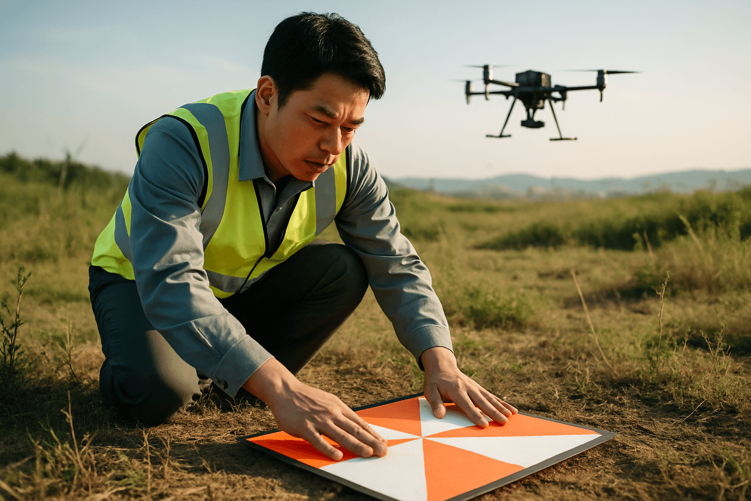
- Reusable Targets (Vinyl, Fabric, or Composite Panels):
- Description: These are pre-fabricated, portable targets typically made of durable materials like vinyl, mesh fabric, or aluminum composite material (ACM) panels. They often feature checkerboard, circular, or bullseye patterns.
- Pros: Reusable, highly visible with strong color contrast, precise center points, easy to transport and deploy, some are designed to be breathable to prevent “doming” in windy conditions.
- Cons: Higher initial cost than paint, still require manual placement and survey.
Permanent GCPs
Permanent GCPs are suitable for sites that require repeated drone surveys over time, offering consistent accuracy and saving time on subsequent flights.
- Painted Pavement or Patio Blocks:
- Description: These involve painting a high-contrast pattern (often checkerboard) onto existing hard surfaces like sidewalks, asphalt, or sturdy patio blocks.
- Pros: Durable, remain in place for long periods, provide consistent reference for recurring missions, can save significant time and cost over multiple surveys.
- Cons: Requires initial installation effort, may need landscape fabric to prevent overgrowth in vegetated areas.
- Natural Features (Less Common for High Accuracy):
- Description: In some cases, easily distinguishable existing features like manholes, specific rock formations, or painted markings on infrastructure can be used as GCPs.
- Pros: No deployment needed.
- Cons: Requires precise surveying of the feature’s center, visibility can vary, and stability/longevity are not always guaranteed.
Coded Targets
Coded targets introduce an element of automation to the GCP workflow.
- Description: These targets feature unique, machine-readable patterns (like QR codes or specific geometric designs) that allow photogrammetry software to automatically detect and identify them in drone images.
- Pros: Automates the matching process, significantly speeding up data processing, reduces manual error in identifying points.
- Cons: Require specific software compatibility, may need to be larger for higher altitude flights to ensure detectability.
Smart/Active GCPs
Representing a more advanced category, smart GCPs integrate technology to streamline the surveying process.
- Description: These are specialized targets (e.g., Propeller AeroPoints) that contain integrated GNSS (Global Navigation Satellite System) receivers. They can self-survey their precise locations over time.
- Pros: Significantly reduce the time and effort required for ground control, increase reliability by automatically providing highly accurate coordinates, simplify fieldwork.
- Cons: Higher initial investment, require a clear view of the sky for optimal performance.
This type of GCP relates to the broader concept of active control points in surveying, which are permanently fixed GNSS equipment that continuously collect satellite observations, as opposed to passive control points which are physical benchmarks with known locations that require manual surveying.
GCP Placement Strategies
Effective placement is critical for optimal mapping accuracy. Experts recommend a minimum of five GCPs for a flight area, distributed strategically.
- Even Distribution: Place GCPs evenly across the entire area of interest, ideally one in each corner and at least one in the middle to prevent “doming” (where the center of the map warps).
- Elevation Changes: If the survey area has significant elevation changes, place GCPs at the highest, lowest, and middle points.
- Buffer Zone: Place GCPs at least 15 meters (50 feet) from the boundary of the map area to avoid cutting them off in images.
- Avoid Obstructions: Ensure GCPs have a clear view of the sky and are away from buildings, vehicles, and metallic interference.
The Role of Checkpoints
While GCPs are used to tie the map to known coordinates, checkpoints (which are physically the same as GCPs and surveyed identically) are used after processing to verify the accuracy of the drone map. By comparing the known coordinates of checkpoints with their calculated positions in the processed map, surveyors can independently assess and quantify the accuracy achieved.
GCPs with RTK/PPK Drones
Drones equipped with Real-Time Kinematic (RTK) or Post-Processed Kinematic (PPK) technology offer enhanced GPS accuracy, reducing the reliance on a large number of GCPs. However, even with RTK/PPK drones, GCPs are still valuable for quality control, error correction, and achieving the highest possible absolute accuracy, particularly in complex terrains or when aligning with existing terrestrial measurements.
In conclusion, the choice of GCP type depends on project requirements, budget, desired accuracy, and site characteristics. From simple painted marks to sophisticated smart targets, understanding these different types is crucial for any successful drone surveying and mapping operation.


