The health of lakes and reservoirs is paramount for ecological balance, drinking water supply, and recreational activities. Traditional methods of water quality monitoring, relying heavily on manual sampling and laboratory analysis, are often resource-intensive, time-consuming, and provide only discrete “point-based assessments”. These limitations lead to gaps in detecting rapid changes and contamination events, especially across large or inaccessible water bodies. The emergence of drone-based multispectral imaging has revolutionized environmental monitoring, offering a dynamic, high-resolution, and cost-effective solution for assessing water quality in these vital aquatic ecosystems.
The Evolution of Water Quality Monitoring
Historically, water quality assessment has relied on in-situ measurements and laboratory analysis of collected samples. While accurate, these methods provide limited spatial coverage and infrequent temporal snapshots, often failing to capture the dynamic and heterogeneous nature of water bodies. Satellite-based remote sensing offered a broader perspective but was often constrained by coarse spatial and temporal resolutions, as well as atmospheric interference like cloud cover. Unmanned Aerial Vehicles (UAVs), commonly known as drones, equipped with advanced sensor payloads, bridge this gap by offering flexible, high-resolution data acquisition at lower altitudes, overcoming many of the limitations of traditional and satellite-based approaches.
The Science Behind Multispectral Imaging
Multispectral imaging is a remote sensing technique that captures images across several discrete bands of the electromagnetic spectrum, extending beyond the visible light range (Red, Green, Blue – RGB) into near-infrared (NIR) and red-edge bands. Unlike human eyes or standard RGB cameras, multispectral sensors detect specific wavelengths of light that interact uniquely with different components within the water column. The presence and concentration of various water quality parameters, such as chlorophyll-a, suspended sediments, or dissolved organic matter, alter the water’s spectral reflectance characteristics. By analyzing these distinct spectral signatures, researchers can infer the concentration and spatial distribution of these parameters.
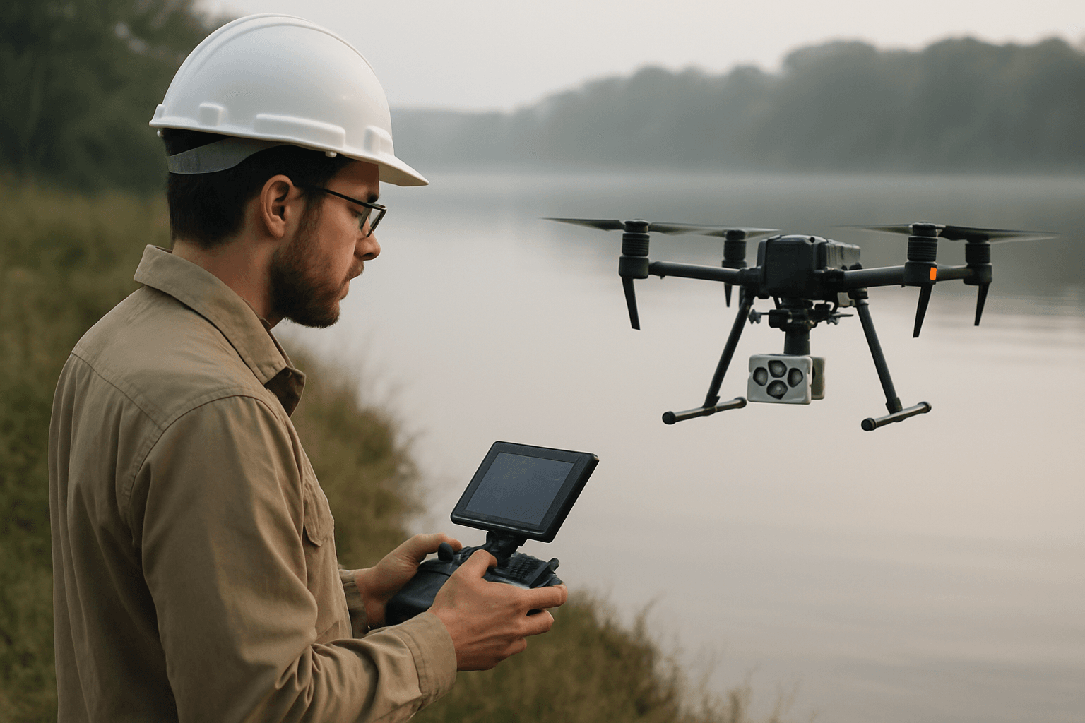
Common multispectral sensors used on drones typically include blue, green, red, red-edge, and near-infrared bands. These sensors often come with a Downwelling Light Sensor (DLS) and a calibrated reflectance panel (CRP) for radiometric calibration, ensuring accurate and reliable measurements of downwelling irradiance and solar angle during flights.
Applications in Water Quality Assessment
Drone-based multispectral imaging is capable of estimating a wide array of water quality parameters, providing crucial insights into the ecological status of lakes and reservoirs.
Chlorophyll-a and Algal Blooms
Chlorophyll-a (Chl-a) is a primary photosynthetic pigment found in algae and cyanobacteria, making its concentration a key indicator of algal biomass and potential eutrophication. High concentrations of Chl-a often signify harmful algal blooms (HABs), which can deplete dissolved oxygen, produce toxins, and impair water utility. Multispectral sensors, particularly the green and red-edge bands, are highly sensitive to Chl-a. Research indicates strong correlations between Chl-a concentrations and reflectance values in these bands, allowing for the creation of predictive maps. Studies have successfully used UAVs to monitor Chl-a variations with high spatial resolution, improving upon coarser satellite data.
Turbidity and Suspended Sediments
Turbidity, a measure of water clarity, is influenced by the scattering and absorption of light by suspended particles like silt, clay, organic matter, and microorganisms. Total Suspended Solids (TSS) quantify the dry weight of these particles. Both turbidity and TSS are critical indicators of water quality, affecting light penetration for aquatic life and potentially carrying pollutants. Multispectral imagery, particularly in the red and near-infrared bands, is effective in estimating turbidity and TSS concentrations because these bands are strongly affected by light scattering from suspended particles. Drones enable high-resolution mapping of these parameters, revealing spatial variations that traditional methods might miss. Studies have shown strong correlations (e.g., R² values around 0.77-0.78 for TSS and turbidity) using linear regression models.
Dissolved Oxygen (DO) and Other Parameters
Dissolved oxygen is a fundamental indicator of water quality, crucial for aquatic life. While direct remote sensing of DO can be challenging, multispectral images can be sensitive to DO and correlated with factors like temperature, biomass, and organic matter. Predictive models, often leveraging machine learning algorithms, have shown success in estimating DO from multispectral data.
Beyond these, multispectral imaging can also be correlated with parameters such as pH, electrical conductivity (EC), oxidation-reduction potential (ORP), and even certain metal ions in complex water bodies like those affected by acid mine drainage. While some parameters like Total Nitrogen (TN) and Total Phosphorus (TP) are considered non-optically sensitive, advancements in machine learning and data fusion techniques are showing promise for their quantitative retrieval from multispectral data. Temperature can also be mapped using multispectral or thermal sensors on drones.
Advantages of Drone-Based Systems
The integration of multispectral sensors with UAVs offers several compelling advantages for water quality monitoring:
- High Spatial Resolution: Drones can capture imagery at centimeter-scale resolution, significantly higher than satellite data (which can be 300m or coarser), allowing for the detection of fine-scale spatial heterogeneity and localized pollution sources.
- Flexible Temporal Resolution: Unlike satellites with fixed revisit times, drones offer on-demand data acquisition, enabling frequent and timely monitoring campaigns to track rapid changes, short-term events, or seasonal variations in water quality. This flexibility is crucial for detecting sudden pollution events or dynamic processes like algal blooms.
- Cost-Effectiveness and Accessibility: Compared to manned aerial surveys or extensive manual sampling campaigns, drone operations are generally less expensive and require less personnel. They can easily access remote, hazardous, or difficult-to-reach areas of lakes and reservoirs, improving safety for monitoring personnel.
- Non-Contact Detection: Drones monitor water bodies from above, avoiding direct contact and thus preventing secondary contamination of the water body that might occur with traditional sampling methods.
- Comprehensive Spatial Data: Drones provide geo-tagged, wide-area data, facilitating the creation of detailed spatial distribution maps of water quality parameters, which are invaluable for Geographic Information System (GIS) integration and informed decision-making.
Challenges and Limitations
Despite the numerous advantages, drone-based multispectral imaging for water quality assessment faces several challenges:
- Atmospheric and Surface Effects: Water bodies often appear dark in images, leading to a lower signal-to-noise ratio compared to land applications. Phenomena like “sun glint” (specular reflection of sunlight off the water surface) and “sky glint” (reflection of sky radiance) can significantly affect the accuracy of reflectance measurements. Advanced atmospheric correction algorithms and careful flight planning (e.g., avoiding direct sun angles) are crucial to mitigate these effects.
- Data Processing Complexity: Processing multispectral drone imagery requires specialized software and expertise. Steps include geometric registration, radiometric correction using calibration panels and DLS, stitching individual images into orthomosaics, and then extracting spectral signatures. The dynamic nature of water bodies due to currents or tides can complicate orthomosaic generation.
- Sensor Calibration and Model Robustness: Accurate retrieval of water quality parameters relies on robust empirical or semi-analytical models linking spectral reflectance to in-situ measurements. These models often require site-specific calibration and can vary temporally, meaning a single model may not suffice for dynamic estuarine or lake systems.
- Depth Penetration Limitations: Multispectral remote sensing primarily captures information from the surface layer of the water column. In optically shallow waters, bottom reflectance can significantly influence the spectral signal, posing a challenge for accurate water quality measurements.
- High Implementation Costs (Initial): While operational costs are lower, the initial investment in high-quality multispectral sensors and UAV platforms can be substantial, limiting widespread adoption, especially in developing regions. Hyperspectral sensors, which offer even more spectral detail, are typically heavier and more costly, requiring larger drone platforms.
- Regulatory Issues: Drone operations are subject to aviation regulations, which can vary by region and may impose restrictions on flight altitude, distance, and permissible areas, potentially limiting monitoring scope.
Data Processing and Analysis Workflow
A typical workflow for processing drone-based multispectral imagery for water quality assessment involves several critical steps:
- Flight Planning and Data Acquisition: Missions are planned to ensure optimal flight altitude, image overlap (e.g., 80% frontal, 75% side), and speed to achieve desired ground sample distance (GSD). Simultaneous in-situ water sample collection is vital for ground-truthing and model calibration.
- Radiometric Calibration and Pre-processing: Raw multispectral images undergo radiometric correction using data from calibration panels and downwelling light sensors to convert digital numbers into reflectance values, accounting for illumination changes and atmospheric effects. Software like Pix4D mapper is commonly used for this.
- Orthomosaic Generation: Individual corrected images are stitched together to create georeferenced orthomosaics of the water body. This step can be challenging over water surfaces due to their dynamic nature and lack of stable features for traditional photogrammetric methods. Novel workflows, sometimes manual, are developed to address this.
- Spectral Signature Extraction: Mean reflectance values for specific water bodies or sampling points are extracted from the orthomosaic.
- Model Development and Inversion: Statistical analyses (e.g., simple or multiple linear regression) and machine learning algorithms (e.g., Random Forest, XGBoost, Neural Networks) are employed to establish relationships between spectral reflectance values (or derived spectral indices/band ratios) and measured in-situ water quality parameters.
- Spatial Mapping: Once robust models are established, they are applied to the entire multispectral orthomosaic to generate high-resolution spatial distribution maps of the water quality parameters.
Case Studies and Real-World Applications
Drone-based multispectral imaging has been successfully applied in various real-world scenarios for water quality monitoring:
- Mining Areas: In the Iberian Pyrite Belt, drone multispectral data combined with in-situ chemical data were used to accurately estimate parameters like pH, electrical conductivity, and concentrations of various metals in acidic mining waters, demonstrating the technology’s utility in complex environments.
- Estuaries and Coastal Waters: Studies in subtropical estuaries have shown that drone-based multispectral imagery can produce useful “snapshot” prediction maps for chlorophyll, blue-green algae, and dissolved oxygen, despite the temporal variability requiring dynamic models. Similarly, in coastal waters, multispectral drones have derived chlorophyll-a and total suspended solids concentrations at centimeter-scale resolution, significantly improving upon lower resolution satellite data.
- Small Reservoirs and Urban Rivers: UAVs have been employed to assess water quality in small inland reservoirs and urban rivers, successfully retrieving parameters like total nitrogen, total phosphorus, and chemical oxygen demand, and revealing fine-scale spatial heterogeneity often missed by satellite-based methods. For instance, a study on the Zhanghe River in China used UAV multispectral images and machine learning to map Chl-a, TN, TP, and COD, demonstrating the potential for timely monitoring.
- Siltation Monitoring: Drones equipped with multispectral cameras have been used to monitor siltation in reservoirs by recording water color variations and mapping Total Suspended Solids (TSS) load fluctuations, especially valuable during rainy seasons when cloud cover limits satellite imagery.
Future Outlook and Emerging Trends
The field of drone-based multispectral imaging for water quality assessment is continuously evolving, with several promising trends on the horizon:
- Hyperspectral Integration: While more expensive, hyperspectral sensors offer hundreds of narrow, contiguous spectral bands, providing even more detailed spectral information for more accurate and precise retrieval of water quality parameters like dissolved organic matter and specific pollutants. The decreasing cost and size of these sensors may lead to wider adoption.
- Advanced AI and Machine Learning: The integration of sophisticated machine learning algorithms (e.g., deep learning, stacked ensemble models) will continue to improve the accuracy and robustness of water quality parameter inversion models, especially for non-optically sensitive parameters.
- Multi-Sensor Fusion: Combining multispectral data with other drone-mounted sensors such as thermal cameras (for temperature), LiDAR (for bathymetry and water level), and even gas or custom sensors, can provide a more holistic understanding of water quality and pollution events.
- Real-time Monitoring and IoT Integration: Future developments aim for real-time analysis and decision-making by integrating drone data with Internet of Things (IoT) systems, allowing for immediate detection and response to contamination events.
- Automated Flight and Data Processing: Continued advancements in autonomous flight capabilities and automated data processing workflows will further enhance the efficiency and scalability of drone-based water quality monitoring programs.
- Standardization of Protocols: Addressing the lack of standardized protocols for data collection and analysis will be crucial for ensuring consistency and comparability across different studies and regions.
Conclusion
Drone-based multispectral imaging represents a transformative advancement in water quality monitoring for lakes and reservoirs. By providing high-resolution, spatially comprehensive, and flexible data acquisition capabilities, it overcomes many limitations of traditional and satellite-based methods. While challenges related to atmospheric correction, data processing, and model generalization persist, ongoing research and technological innovations, particularly in sensor development and artificial intelligence, are continuously enhancing its accuracy and applicability. As this technology matures, drone-based multispectral imaging will undoubtedly play an increasingly vital role in ensuring the health and sustainable management of global freshwater resources.


