As global populations grow and climate change intensifies drought conditions, the pressure on agricultural water resources mounts, making efficient irrigation more critical than ever before. Traditional irrigation methods, often relying on fixed schedules and uniform water application, frequently lead to significant water wastage and uneven crop development. However, a new era of precision agriculture is emerging, spearheaded by the innovative application of drone technology, offering a data-driven approach to optimize water usage and detect plant water stress with unprecedented accuracy and timeliness.
The Imperative of Precision Irrigation
Agriculture accounts for a substantial portion of global freshwater consumption. The rising demand for food production, coupled with dwindling water supplies, necessitates a radical shift towards more sustainable and efficient farming practices.
Global Water Scarcity and Agricultural Demands
Global drylands, which cover about 41% of Earth’s surface and are home to 38% of the world’s population, face significant challenges from water scarcity and food insecurity. Efficient irrigation management is paramount to optimizing water use and sustaining agricultural productivity in these regions. Traditional irrigation often results in overwatering or underwatering, leading to reduced yields and environmental impact.
Limitations of Traditional Irrigation Methods
Traditional methods for assessing crop health and water status, such as manual observation or satellite imagery, often lack the precision and timeliness required for effective decision-making. Satellite data, while useful, can be costly and less effective than closer drone imaging, which is also less impacted by cloud cover. These methods can be time-consuming and labor-intensive, making it difficult to manage large and varied landscapes efficiently.
Drones: Revolutionizing Irrigation Management
Unmanned Aerial Vehicles (UAVs), commonly known as drones, have emerged as powerful tools in modern agriculture, transforming farm management and irrigation practices. By equipping farmers with real-time, actionable insights, drones enable the precise application of water, fertilizers, and pesticides, optimizing crop health and yield while minimizing environmental footprint.
Enhanced Data Collection Capabilities
Drones equipped with advanced sensors and cameras can collect detailed data about soil conditions, crop health, and moisture levels. This includes high-resolution imagery and vital data related to plant health and stress indices. Their ability to fly at low altitudes allows for the generation of very high spatial resolution data, up to 5 cm, making them highly suitable for farm-scale research. Drones can also provide accurate field mapping, including elevation information, which helps growers identify drainage patterns and wet/dry spots for more efficient watering.
Real-time Monitoring and Decision Making
One of the key advantages of drones is their capacity for real-time data collection on crop conditions and soil moisture levels. This instant feedback allows farmers to identify issues and make informed decisions swiftly, moving from guesswork to data-driven strategies. Drones can cover large areas quickly, facilitating faster scouting for issues like water stress, pest infestations, or nutrient deficiencies before they become major problems.
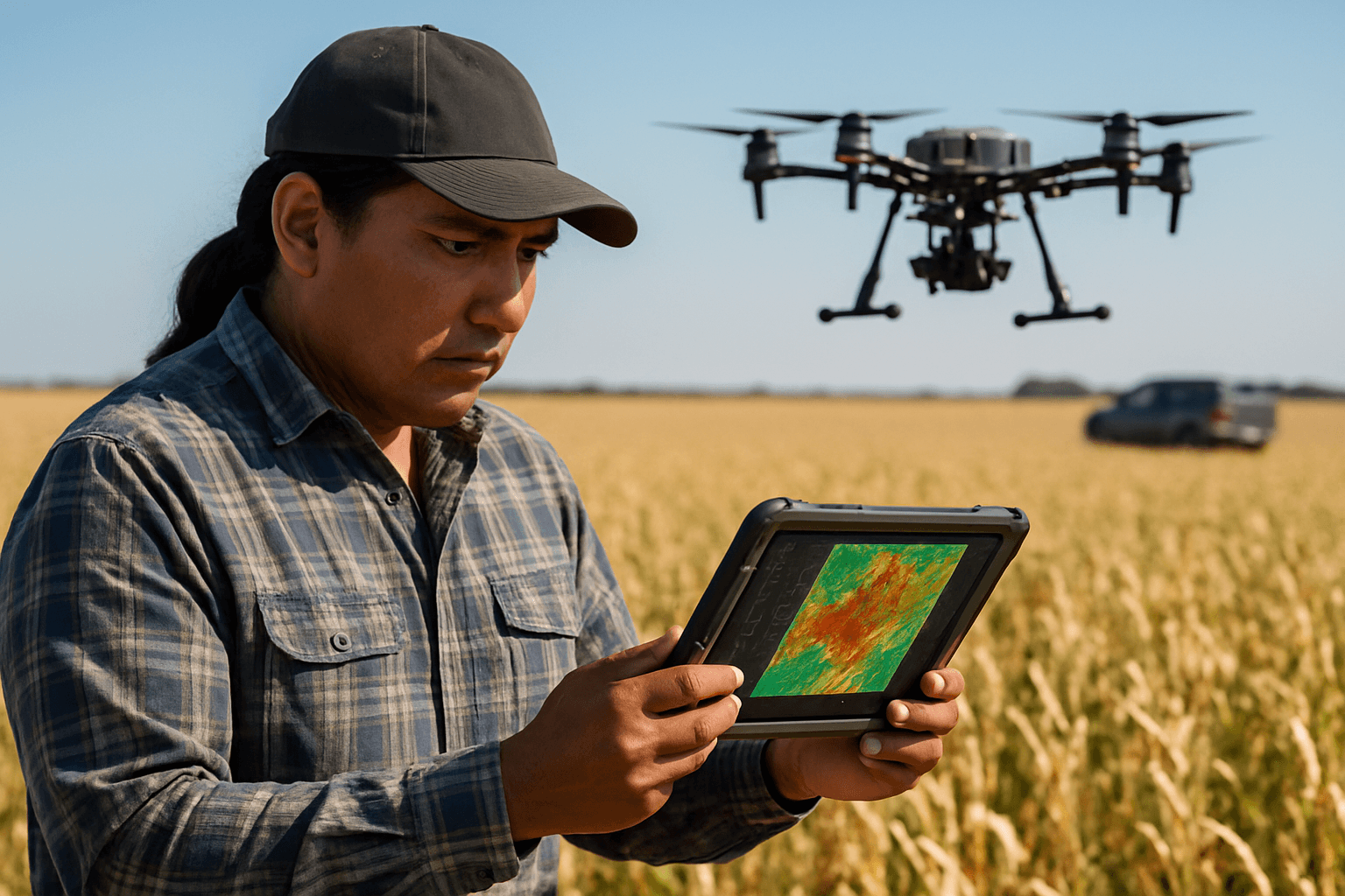
How Drones Detect Water Stress
Drones utilize a variety of sophisticated sensors to detect early signs of water stress in crops, often before they are visible to the human eye. Water stress detection primarily relies on temperature-based and reflectance-based indices.
Multispectral and Hyperspectral Imaging
Multispectral cameras capture images across different wavelengths of light (blue, green, red, red-edge, and near-infrared reflectance bands), allowing farmers to detect signs of stress or disease in crops. Indices like the Normalized Difference Vegetation Index (NDVI) use detailed color information to indicate plant health and growth vigor. Hyperspectral imaging provides even more detailed spectral insights into plant chemistry, including nitrogen and chlorophyll levels, which are critical markers for plant nutrition and stress. The application of UAV-based hyperspectral imaging for water stress detection has evolved significantly, integrating advanced machine learning techniques for improved accuracy.
Thermal Imaging for Evapotranspiration Analysis
Thermal cameras detect subtle temperature changes in leaves and the canopy, which are key indicators of water stress. When plants experience water scarcity, their stomata close to conserve moisture, leading to an increase in leaf temperature due to reduced evaporative cooling (transpiration). Thermal imaging drones are particularly effective at revealing underground leaks by showing temperature differences in the soil, identifying irrigation system failures such as broken sprinkler heads or pipeline leaks. The Crop Water Stress Index (CWSI), derived from thermal imagery, is a reliable tool for real-time irrigation management.
Lidar for Topographical Mapping and Water Runoff
LiDAR (Light Detection and Ranging) technology can be used for accurate topographical mapping, which helps identify moisture level alterations in landscapes and determine drainage patterns. This detailed 3D mapping provides valuable insights into soil composition, moisture levels, and topography, helping farmers make informed decisions about planting and irrigation planning.
Benefits of Drone-Based Irrigation
Integrating drones into irrigation systems offers numerous advantages, making it a smarter, faster, and more cost-effective approach for modern agriculture.
Optimized Water Usage and Conservation
By mapping and monitoring fields with drones, areas that are over-watered or under-watered can be easily identified, optimizing irrigation systems and preventing wastage. This targeted approach ensures that crops receive adequate moisture without waste, potentially reducing water consumption by as much as 30%. Drones enable precision irrigation systems to apply water only where and when needed.
Improved Crop Yield and Quality
Precision agriculture, enabled by drones, can increase crop yields by as much as 5% to 20% while potentially reducing input costs by 15% to 30%. Early detection of water stress and precise interventions safeguard crop health and productivity, leading to healthier crops and improved quality of produce.
Reduced Operational Costs
Drones significantly reduce the need for manual labor during irrigation management, covering large regions in a fraction of the time it would take for traditional approaches. This efficiency translates to lower water bills and reduced labor expenditures, ultimately lowering overall operational costs for farmers.
Early Detection of Issues
Drones allow for the early detection of water stress, nutrient deficiencies, pest infestations, and irrigation system failures (like leaks or blockages). This early warning system facilitates timely corrective actions, preventing significant crop damage and maximizing water use efficiency.
Challenges and Considerations
Despite the significant advantages, the widespread adoption of drone technology in agriculture faces several hurdles that need to be addressed.
Regulatory Hurdles and Data Privacy
Complex regulatory requirements regarding drone usage, airspace permissions, and operator certifications vary significantly by country, creating confusion and delays. Furthermore, concerns about data privacy and security when collecting extensive farm data also need to be managed. Beyond Visual Line of Sight (BVLOS) flight regulations are a particular area requiring harmonization and further technological development.
Initial Investment and Technical Expertise
The initial investment in high-end drones with advanced sensors and cameras can be substantial, especially for small and marginal farmers. Beyond hardware, there are additional costs for software, training, and ongoing maintenance. Operating drones and analyzing the large volumes of data they collect require specialized skills, posing a steep learning curve for many farmers.
Data Processing and Interpretation
Drones generate vast amounts of data that need to be processed and analyzed effectively to extract valid and actionable insights. Poor internet connectivity in rural areas can hinder data processing, especially for cloud-based services. The interpretation of complex multispectral and thermal imagery also requires specific expertise, and methods for this interpretation still require further research and development.
The Future of Drone-Aided Agriculture
The trajectory of drone technology in agriculture points towards increasingly sophisticated and integrated systems that promise even greater efficiency and sustainability.
AI and Machine Learning Integration
The future will see more advanced AI and machine learning algorithms providing even more accurate predictions and insights from drone-collected data. These algorithms can unravel intricate data patterns, differentiate between overlapping plant stress signals (e.g., nutrient vs. water deficiency), and optimize plant survival rates based on local conditions. This will lead to smarter decisions, accurate yield forecasts, and timely responses to crop issues.
Swarm Robotics and Autonomous Operations
Expect to see fully automated drone fleets managing entire farms without human input, making farming more efficient and less labor-intensive. Swarm robotics for integrated farm management and autonomous decision systems will further enhance operational capabilities. Nano-drones could allow for even more precise applications and monitoring.
Integration with IoT and Farm Management Systems
Future advancements include seamlessly integrating drone data with Internet of Things (IoT) devices and broader farm management systems. This multi-scale monitoring framework, combining drone data with satellite and ground sensors, will provide comprehensive insights for smart irrigation systems and overall farm planning. 5G integration will enable faster, more reliable connectivity for real-time data processing and decision-making.
In conclusion, drones are fundamentally transforming agricultural practices, moving towards an era of unprecedented efficiency and sustainability. By providing precise, real-time data, they empower farmers to optimize water usage, mitigate water stress, and ultimately achieve higher yields with a reduced environmental footprint. While challenges remain, continuous research and development, coupled with supportive regulatory frameworks, will continue to unlock the full potential of drone technology in fostering more resilient and productive agricultural systems globally.


