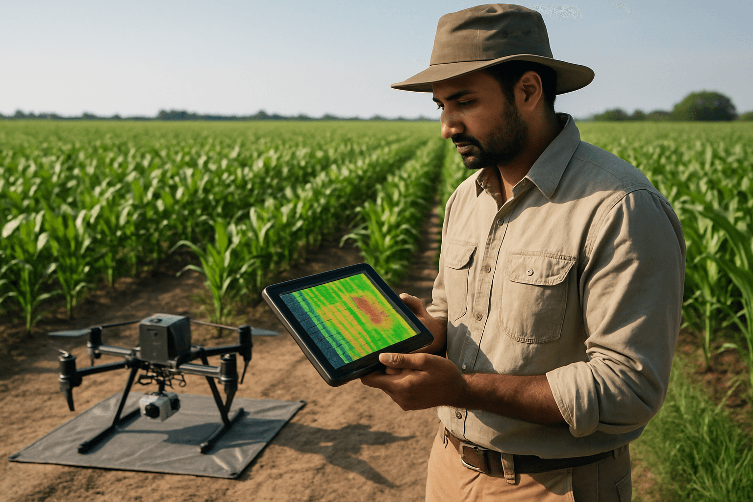
The agricultural landscape is undergoing a significant transformation, moving towards more precise, efficient, and sustainable practices. A key driver of this evolution is the integration of advanced technologies, with drone photogrammetry emerging as a powerful tool for critical crop measurements like plant height and biomass. This innovative approach offers farmers unprecedented insights, replacing traditional, labor-intensive methods with high-resolution, real-time data for optimized decision-making.
The Science Behind Drone Photogrammetry
Photogrammetry is the science of making measurements from photographs. In the context of drones, Unmanned Aerial Vehicles (UAVs) equipped with high-resolution cameras capture a series of overlapping two-dimensional (2D) images of a field from various angles. These images are then processed using specialized photogrammetry software, employing a technique called Structure from Motion (SfM). SfM algorithms analyze the overlapping images to identify common features and reconstruct a detailed three-dimensional (3D) point cloud of the surveyed area.
This 3D point cloud is fundamental to generating various agricultural maps and models, including the Digital Surface Model (DSM), which represents the top surface of the canopy and ground, and the Digital Terrain Model (DTM), which models the bare earth elevation.
Precise Plant Height Measurement
Traditionally, measuring plant height has been a time-consuming, labor-intensive, and often error-prone manual process. Drone photogrammetry offers a highly effective alternative. By subtracting the DTM from the DSM, a Canopy Height Model (CHM) is generated, which accurately represents the height of the vegetation above the ground.
RGB cameras are a cost-effective solution for data collection and are widely used for estimating plant height using SfM. While RGB images are popular, some studies suggest that the derived canopy height from SfM can have issues, such as overestimation due to the camera’s inability to penetrate dense canopies. For applications requiring greater accuracy, particularly in dense vegetation, LiDAR (Light Detection and Ranging) sensors, though more expensive, can offer superior performance as they provide direct 3D measurements and can penetrate the canopy to capture ground information. High-precision positioning systems like RTK-GNSS integrated with drones can further enhance the accuracy of height measurements.
Estimating Plant Biomass with Aerial Data
Biomass, the total mass of organic matter in a given area, is a crucial indicator of plant health, growth, and potential yield. Estimating biomass using drone photogrammetry typically involves establishing a correlation between quantifiable 3D structural parameters derived from drone imagery and actual ground-truth biomass measurements.
Methods for biomass estimation include:
- Correlation with Height and Volume: Parameters like plant height, canopy coverage, crown diameter, and crown volume extracted from photogrammetric point clouds can be correlated with destructive ground-based biomass samples. For instance, studies have shown strong correlations between UAV-based 3D real-scene models and LiDAR results for Above-Ground Biomass (AGB) estimation, with high coefficients of determination (R²).
- Machine Learning and AI Integration: Advanced machine learning and artificial intelligence algorithms are increasingly employed to process drone-collected RGB, multispectral, and LiDAR data for highly accurate biomass prediction. These models can identify complex relationships between spectral and structural features and biomass, often outperforming traditional regression techniques.
- Multispectral Imaging: Drones equipped with multispectral sensors capture data beyond the visible spectrum, providing insights into plant physiological properties that are directly related to biomass and health.
Benefits in Precision Agriculture
The adoption of drone photogrammetry in agriculture provides a multitude of benefits, significantly enhancing the capabilities of precision farming:
- Improved Crop Monitoring: Drones provide high-resolution aerial images that offer detailed insights into crop health, enabling early detection of issues like disease, pest damage, or irrigation problems. This allows farmers to monitor crops more efficiently than ever before.
- Enhanced Decision-Making: Real-time data on soil conditions, moisture levels, plant density, and growth stages empowers farmers to make informed decisions swiftly. This contrasts sharply with manual methods, which are often slower and less comprehensive.
- Resource Optimization: Precision application of fertilizers, pesticides, and water is made possible by accurately identifying areas of need, leading to reduced waste, lower costs, and improved environmental sustainability.
- Cost and Time Savings: Drone mapping surveys can cover large areas in a fraction of the time and cost compared to traditional ground-based methods, providing actionable data almost immediately.
- Accurate Yield Prediction: By delivering timely data on crop growth stages, biomass accumulation, and plant density, drones combined with historical data and AI enable more accurate yield forecasts, aiding in supply planning and risk management.
- Land Management and Planning: Drone surveys offer a comprehensive view of the terrain, identifying topographical changes, drainage issues, erosion risks, and helping optimize planting layouts.
Challenges and Limitations
Despite the numerous advantages, deploying drone photogrammetry in agriculture does come with its challenges:
- Environmental Factors: Dense vegetation can obstruct views, leading to incomplete or inaccurate 3D reconstructions. Factors like swaying leaves and branches can complicate image matching. Changing shadows and adverse weather conditions (e.g., strong winds, rain) can also affect image quality and data accuracy.
- Data Volume and Processing: Drones collect very high-resolution (VHR) imagery, resulting in large data volumes that require significant computational resources for processing, especially with licensed photogrammetry software.
- Accuracy Limitations: While RGB photogrammetry is cost-effective, it may not penetrate dense canopies as effectively as LiDAR, potentially leading to overestimations of canopy height in certain scenarios.
- Operational Considerations: Maintaining visual line of sight (VLOS) and careful flight planning are crucial for safe and effective drone operations.
The Future of Drone Photogrammetry in Agriculture
The trajectory for drone technology in agriculture points towards increasing sophistication and integration. Key trends include:
- Increased Automation: Expect to see fully automated drone fleets managing entire farms, significantly reducing human input and enhancing efficiency.
- Advanced AI and Machine Learning: Drones will become even more adept at collecting and analyzing data, with AI and ML providing real-time, actionable insights for every aspect of farm operations, from pest detection to yield prediction.
- Enhanced Connectivity and IoT Integration: Drones will seamlessly integrate into broader networks of Internet of Things (IoT) sensors across farms, enabling real-time data transmission and remote decision-making for precise irrigation and other tasks.
- Multi-Sensor Data Fusion: The combination of data from various sensors (RGB, multispectral, thermal, LiDAR) will provide more comprehensive and accurate analyses of crop conditions, allowing for holistic farm management.
Drone photogrammetry is no longer just a novel concept but an indispensable tool reshaping modern agriculture. By offering precise, efficient, and data-driven insights into plant height and biomass, it empowers farmers to optimize resource use, boost productivity, and embrace a more sustainable future for food production.


