In the demanding world of agriculture, efficient resource management is paramount. Traditional methods of fertilizer application often lead to uneven distribution, over-application in some areas, and under-application in others, resulting in wasted resources, environmental damage, and suboptimal yields. However, a technological revolution is taking flight above our fields: drones equipped with advanced sensors are transforming how farmers approach crop nutrition, enabling unprecedented precision in optimizing fertilizer application timing.
The Pitfalls of Traditional Fertilizer Application
Historically, farmers have relied on broad-scale, uniform fertilizer applications or, at best, limited soil sampling to guide their nutrient management strategies. This approach, while foundational for generations, suffers from inherent limitations. Fields are rarely uniform; variations in soil composition, moisture levels, topography, and past cropping history create significant heterogeneity across even small parcels of land. Applying a blanket treatment inevitably means some areas receive more nutrients than necessary, leading to nutrient runoff, which can pollute water bodies and contribute to greenhouse gas emissions. Conversely, under-fertilized areas suffer from nutrient deficiencies, stunting growth and reducing potential yields.
How Drones Collect Critical Agricultural Data
The advent of Unmanned Aerial Vehicles (UAVs), commonly known as drones, has ushered in a new era of data-driven agriculture. These aerial platforms are equipped with sophisticated payloads designed to capture a wealth of information about crop health and field conditions.
Advanced Sensing Technologies
- Multispectral and Hyperspectral Cameras: These are perhaps the most crucial sensors for assessing plant health. They capture data beyond the visible light spectrum, including near-infrared (NIR) and red-edge light. Healthy plants reflect more NIR light due to their robust cell structure and chlorophyll content, while stressed or unhealthy plants absorb more red light. This difference is fundamental to calculating vegetation indices.
- Thermal Imaging Sensors: Thermal cameras detect temperature variations across a field. Hotter spots can indicate water stress or uneven irrigation, as plants under stress often transpire less, leading to higher leaf temperatures.
- High-Resolution RGB Cameras: Standard visible light cameras provide detailed visual images, allowing farmers to monitor growth stages, detect weeds, and assess overall field conditions.
- LIDAR (Light Detection and Ranging) Sensors: LIDAR drones create highly accurate elevation maps and provide detailed information about the crop canopy’s 3D structure. This can be vital for understanding drainage patterns and identifying areas prone to waterlogging or erosion.
- Soil Sensors: While not directly mounted on all drones, some advanced systems integrate with soil sampling capabilities or can infer soil conditions like moisture content, pH levels, and nutrient distribution through other remote sensing data. Some drone service providers even offer nitrogen level monitoring using enhanced sensors.
Key Data Points for Fertilizer Optimization
Drones capture data on various parameters that are critical for optimizing fertilizer application:
- Crop Health and Vigor: Multispectral data directly indicates plant vitality.
- Nutrient Deficiencies: Specifically, nitrogen status, which is a key driver of plant growth and chlorophyll content. Drones can identify these deficiencies often before they are visible to the naked eye.
- Soil Moisture Levels: Thermal imagery and specialized sensors can map areas with water stress or excessive moisture.
- Growth Stage Monitoring: High-resolution RGB imagery helps track crop development, which is essential for timing nutrient applications to coincide with critical growth phases.
- Weed Infestation: Drones can identify weed patches, allowing for targeted herbicide application, which in turn ensures fertilizers are not wasted on competing plants.
Processing and Analyzing Drone Data for Actionable Insights
Raw drone data is just the beginning. The real power lies in processing and analyzing this information to generate actionable insights for fertilizer management.
Vegetation Indices: The Language of Plant Health
The most widely used tool for interpreting multispectral data is the Normalized Difference Vegetation Index (NDVI). NDVI quantifies vegetation health by comparing the amount of red light absorbed by plants (used for photosynthesis) to the amount of near-infrared light reflected (indicating cell structure and health). High NDVI values typically correspond to healthy, dense vegetation, while lower values suggest stress, sparse growth, or bare soil.
Other indices, such as the Normalized Difference Water Index (NDWI) for water stress, also play a role in a comprehensive analysis.
From Data to Prescription Maps
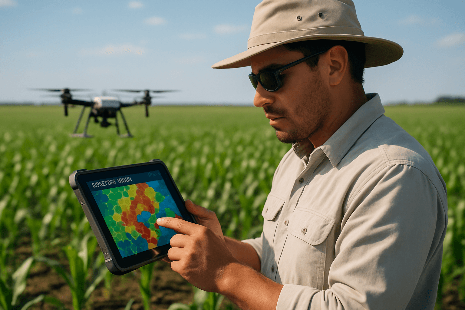
Specialized software is used to process the drone imagery and calculate these vegetation indices. Geographic Information Systems (GIS) integrate this data with other field information (e.g., soil maps, historical yield data, elevation data) to create detailed, georeferenced maps. These maps visually highlight areas of varying crop health and nutrient requirements.
Advanced analytics, often incorporating machine learning and artificial intelligence (AI), further refine these maps into “prescription maps”. These maps are not just visual representations; they are precise instructions that dictate where, when, and how much fertilizer should be applied to specific zones within a field. For example, areas with lower NDVI values (indicating nitrogen deficiency) might be prescribed higher nitrogen rates, while healthy areas receive less, preventing over-application.
Optimizing Fertilizer Application Timing
The core objective of utilizing drone data is to move from reactive to proactive and precise nutrient management.
Identifying Deficiencies Early
Traditional methods often only identify nutrient deficiencies once visual symptoms appear, by which time crop yield may have already been negatively impacted. Drones, with their ability to capture data in the non-visible spectrum, can detect these stresses much earlier. For instance, changes in chlorophyll levels, a key indicator of nitrogen status, can be accurately estimated from drone imagery, allowing for timely intervention. This early detection is crucial because applying fertilizer at the right moment, when the plant can most efficiently utilize it, maximizes uptake and minimizes waste.
Responding to Crop Growth Stages
Different crops have different nutrient requirements at various growth stages. Drone data allows farmers to monitor the actual growth and development across their fields with high precision. This enables them to align fertilizer applications perfectly with critical physiological periods when nutrient demand peaks, such as tillering, flowering, or grain filling. This “just-in-time” approach ensures nutrients are available when the crop needs them most, boosting growth and yield potential.
Variable Rate Technology (VRT) Integration
The culmination of drone data collection and analysis is its integration with Variable Rate Technology (VRT). Drones equipped with VRT spraying systems can adjust fertilizer application rates in real-time as they fly over the field. If a drone detects an area with nutrient deficiency based on the prescription map, it can increase the application rate in that specific zone. Conversely, areas with adequate nutrient levels receive less, preventing over-application. This dynamic adjustment ensures that each part of the field receives the optimal amount of resources, enhancing efficiency and reducing waste.
Benefits of Drone-Optimized Fertilizer Application
The adoption of drone data for fertilizer timing offers a multitude of advantages for modern agriculture:
- Increased Efficiency and Precision: Drones provide highly accurate, granular data, enabling site-specific nutrient application, which is far more precise than traditional methods.
- Reduced Fertilizer Use and Costs: By applying fertilizer only where and when it’s needed, farmers can significantly reduce their overall fertilizer consumption, leading to substantial cost savings—some reports indicate up to 30% reduction in fertilizer and pesticide use.
- Higher Crop Yields: Optimizing nutrient availability at critical growth stages and addressing deficiencies promptly leads to healthier crops and enhanced yield potential.
- Environmental Sustainability: Precision application minimizes nutrient runoff into water bodies, reducing water pollution and other environmental impacts associated with over-fertilization. It also reduces the carbon footprint by using less fertilizer.
- Reduced Soil Compaction: Drone spraying systems apply fertilizers from the air, eliminating the need for heavy machinery that can compact soil, preserving its healthy structure and improving root penetration.
- Improved Accessibility and Speed: Drones can quickly cover large areas (50-100 hectares per day) and access fields that are difficult for traditional machinery to navigate, such as steep slopes or wet, boggy conditions.
- Enhanced Operator Safety: Remote operation reduces human exposure to chemicals and unfavorable field conditions.
Challenges and Future Outlook
Despite the significant advantages, the widespread adoption of drone technology in agriculture faces several challenges. These include the high initial investment costs for drones, sensors, and software, regulatory uncertainties regarding drone operation (especially beyond visual line of sight), and the need for technical expertise for data interpretation and system operation. Weather conditions can also impact drone flights, as strong winds, rain, or fog can hinder operations and data quality.
However, ongoing research and development are continually improving drone capabilities, sensors, data analytics (including AI integration), and battery autonomy. The future may see drone swarms working cooperatively to cover vast areas more efficiently and more sophisticated decision-support systems becoming readily accessible to farmers. Partnerships with drone service providers are also emerging as a way to overcome the barriers of initial investment and technical expertise.
Conclusion
The integration of drone data into fertilizer application strategies represents a profound shift towards truly precision agriculture. By providing real-time, high-resolution insights into crop health, nutrient status, and field variability, drones empower farmers to make informed, site-specific decisions about when, where, and how much fertilizer to apply. This not only drives significant economic benefits through cost savings and increased yields but also champions environmental stewardship by minimizing waste and reducing pollution. As drone technology continues to evolve, its role in optimizing fertilizer application timing will become an indispensable component of sustainable and productive farming practices worldwide.


