The towering structures that form the backbone of our global communication networks—telecommunication towers—are critical assets requiring regular inspection and maintenance. Traditionally, this process has been fraught with hazards, demanding technicians to scale immense heights, often in challenging conditions, risking falls, electrical exposure, and radiofrequency (RF) radiation. These manual inspections are not only dangerous but also time-consuming, costly, and susceptible to human error, leading to potential oversights and extended downtimes.
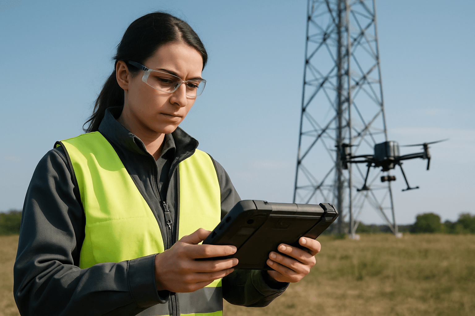
However, a technological revolution is underway, transforming how these vital structures are monitored: the integration of unmanned aerial vehicles (UAVs), commonly known as drones. Drones offer a safer, faster, more efficient, and significantly more accurate alternative to traditional methods, enabling detailed assessments without placing human lives at risk. This guide delves into the methodology, equipment, and best practices for leveraging drones to inspect telecommunication towers, ensuring the integrity and functionality of our interconnected world.
The Inherent Advantages of Drone-Based Inspections
The shift towards drone technology in telecommunications infrastructure inspection is driven by a compelling array of benefits that far outweigh conventional approaches.
Enhanced Safety for Personnel
One of the most significant advantages of drone inspections is the drastic improvement in safety. By eliminating the need for human climbers, drones remove the risks associated with falls, electrical hazards, and exposure to harmful RF radiation. This ensures personnel can conduct thorough inspections from a safe distance on the ground.
Increased Efficiency and Speed
Drones can complete comprehensive tower inspections in a fraction of the time required for manual methods, often inspecting multiple towers in a matter of hours compared to days. This rapid assessment capability minimizes operational disruptions, reduces tower downtime, and accelerates maintenance schedules, ultimately leading to substantial cost savings.
Superior Data Accuracy and Detail
Equipped with advanced sensors and high-resolution cameras, drones capture intricate details that may be missed by the naked eye. This precision allows for the accurate identification of structural defects like rust, cracks, and loose bolts, as well as equipment malfunctions such as overheating components detectable via thermal imaging. The detailed data ensures maintenance tasks are performed based on reliable, high-quality information.
Cost-Effectiveness and Resource Optimization
Drone inspections significantly reduce operational costs by eliminating the need for expensive equipment like cranes, scaffolding, and extensive labor. Furthermore, the ability to conduct more frequent inspections leads to early detection of minor issues, preventing them from escalating into costly major repairs.
Unparalleled Accessibility and Remote Operations
Telecommunication towers are often located in remote, challenging, or hazardous terrains that are difficult and expensive to access manually. Drones overcome these challenges, flying effortlessly to isolated locations and performing inspections without the need for physical access by crews.
Facilitating Predictive and Preventative Maintenance
The wealth of detailed data collected by drones supports advanced analytics, enabling telecom companies to monitor wear and tear on components, detect early signs of degradation, and plan preventative maintenance actions. This proactive approach helps extend the lifespan of infrastructure and ensures continuous service.
Essential Drone Hardware and Software for Telecom Inspections
A successful drone inspection program relies on the right combination of robust hardware and intelligent software.
Drone Selection and Capabilities
When choosing a drone for telecommunication tower inspections, several key features are paramount:
- Stability: The drone must maintain stable flight, particularly in the often windy conditions encountered at tower heights, to capture clear data.
- Battery Life: Extended flight times are crucial for covering large areas or multiple towers efficiently. Drones with hot-swappable batteries can further reduce downtime between flights.
- Durability and Weatherproofing: Industrial-grade drones capable of withstanding harsh weather conditions are essential for reliable operation.
- Advanced Features: Obstacle avoidance systems and RTK (Real-Time Kinematic) positioning provide enhanced safety and centimeter-level accuracy.
Notable drones often recommended for tower inspections include the DJI Matrice 350 RTK, SwitchBlade-Elite, Inspired Flight IF800 Quadcopter, Voliro T, Skydio X10, and ANAFI Ai.
Payloads and Sensors
The effectiveness of a drone inspection largely depends on its payload:
- High-Resolution RGB Cameras (4K): These are essential for capturing detailed visual imagery, enabling inspectors to identify surface defects like rust, corrosion, cracks, loose bolts, and even read model and serial numbers of antennas. Optical zoom capabilities (e.g., DJI ZenMuse Z30 with 30x optical zoom) are vital for inspecting components from a safe distance, minimizing electromagnetic interference.
- Thermal Imaging Sensors: These cameras detect heat signatures, allowing for the identification of overheating equipment, electrical faults, or damaged wiring that might not be visible optically.
- LiDAR Systems: LiDAR (Light Detection and Ranging) creates highly accurate 3D models of the tower structure, enabling precise measurements and detailed structural assessments.
- Corona Cameras: Specialized cameras capable of detecting electrical discharges, which are indicative of potential insulation issues or equipment malfunctions.
Software for Planning, Processing, and Analysis
The data collected by drones is raw; specialized software transforms it into actionable insights:
- Flight Planning Software: Tools like Hammer Missions (Hammer Hub) facilitate automated mission planning, allowing pilots to define flight paths, set altitudes, radius, and ensure optimal image overlap (e.g., 70% or more) for comprehensive data capture. They can generate helical orbits around the tower, ensuring all sides are captured effectively.
- Data Processing and Analytics Platforms: These platforms ingest raw drone data and process it to generate 2D orthomosaics, 3D models, and digital twins of the tower. Examples include Optelos, Pointivo, PIX4Dmapper, DroneDeploy, Mapware, ArcGIS, and vHive.
- AI-Powered Analytics: Many platforms integrate artificial intelligence to automatically detect defects, perform precise measurements (e.g., antenna azimuth, downtilt, spacing, height), compare as-built structures to CAD designs, and track changes over time.
- Reporting and Visualization: These tools enable inspectors to annotate detected issues directly on 3D models, generate detailed PDF reports, and share findings with stakeholders through centralized, cloud-based platforms.
- Real-time Monitoring: Some systems offer live video streaming, allowing ground teams to monitor the inspection in real-time, provide immediate feedback, and make on-the-spot decisions.
The Drone Inspection Workflow: A Step-by-Step Guide
Executing a successful drone inspection of a telecommunication tower involves a structured workflow, from meticulous planning to detailed analysis.
1. Pre-Flight Planning and Risk Assessment
Thorough preparation is the cornerstone of a safe and effective drone inspection.
- Regulatory Compliance: Adherence to local aviation laws is paramount. In the United States, this includes complying with FAA Part 107 regulations for commercial drone operations, which mandate pilot certification (Remote Pilot Certificate), drone registration, and specific operational limitations (e.g., maintaining visual line-of-sight (VLOS), altitude limits of 400 feet, and restrictions on flying over people or at night without a waiver). Obtain any necessary authorizations for flights in controlled airspace.
- Weather Conditions: Crucially, check the weather forecast for wind speed, precipitation, temperature extremes, and visibility. Drones have wind speed limits (often 20-25 mph), and heavy rain can damage electronics. Postpone flights if conditions are unfavorable to ensure data quality and safety.
- Site Survey and Obstacle Analysis: Conduct a preliminary assessment of the inspection site to identify potential hazards such as guy wires, electromagnetic interference from the tower, bird nests, or structural weaknesses. Understand the terrain, especially for remote locations.
- Mission Planning: Define the specific goals of the inspection (e.g., routine check, pre-work assessment, damage assessment). Use specialized flight planning software to generate an automated flight path. This typically involves setting altitudes, defining a safe radius around the tower, and ensuring sufficient image overlap (e.g., 70% or more) for accurate 3D model reconstruction.
- Equipment Checklist: Perform a comprehensive pre-flight inspection of the drone, including checking battery levels, propeller integrity, camera functionality, and the communication link between the drone and the ground control station. Carry backup batteries, especially for extensive inspections or remote sites.
2. Data Acquisition (Flight Operations)
Once planning is complete and conditions are optimal, proceed with the flight.
- Safe Takeoff: Initiate flight with a stable hover for about 30 seconds after takeoff to allow the drone to stabilize and to detect any immediate issues.
- Maintain Safe Distance: While detailed data is desired, it’s important to maintain an optimal and safe distance from the tower (e.g., at least 5 meters) to avoid electromagnetic interference and physical collisions, especially near guy wires. Utilize the camera’s zoom capabilities to capture close-up details from a distance.
- Automated Flight Path Execution: Execute the pre-planned automated flight mission, which often involves helical orbits around the tower at various altitudes, capturing images from multiple angles (e.g., 150-250 images for a typical tower inspection). Adjust the camera’s gimbal tilt as the drone ascends and orbits to keep the point of interest centered in the frame.
- Real-time Monitoring: Continuously monitor the drone’s flight path, data stream, and battery status using the ground control station. Live video feeds enable immediate identification of critical issues.
- Maintain Visual Line of Sight: Always ensure the drone remains within the visual line of sight of the pilot or a designated visual observer, as required by regulations in many regions.
- Post-Flight Data Verification: After the flight, it’s advisable to quickly review the captured images and videos on-site to ensure data quality, focus, and completeness before leaving the location.
3. Data Processing and Analysis
The collected data is then transformed into actionable insights.
- Data Upload and Processing: Transfer the drone’s data (images, videos, sensor data) from the SD card to a specialized processing platform (cloud-based or local software). The software processes this data to generate high-resolution 2D maps and precise 3D models or digital twins of the telecommunication tower.
- AI-Powered Analytics: Leverage advanced analytics tools, often augmented with AI, to automatically detect specific defects (e.g., rust, corrosion, cracks, loose bolts, cable damage), measure antenna azimuths, downtilts, spacing, and heights. These tools can compare current conditions against historical data or design specifications.
- Annotation and Reporting: Inspectors can digitally annotate detected issues directly on the 3D models or images within the platform. Detailed inspection reports, often in PDF format, can then be generated, summarizing findings, highlighting critical issues, and providing actionable recommendations for maintenance and repair. These reports can include geo-referenced fault locations for technicians.
- Integration and Sharing: The analyzed data and reports can be integrated with existing asset management systems, providing a centralized repository for tower information and enabling seamless collaboration among engineers, maintenance crews, and management.
Challenges and Best Practices for Optimal Drone Tower Inspections
While drones offer immense advantages, successful implementation requires addressing certain challenges and adhering to best practices.
Key Challenges
- Battery Life Limitations: Extended inspections or multiple towers may require multiple drones or a supply of hot-swappable spare batteries.
- Environmental Factors: High winds, heavy rain, extreme temperatures, and poor visibility can impact drone performance, data quality, and flight safety.
- Electromagnetic Interference: The radio signals from active telecommunication towers can potentially interfere with drone control signals and GPS, requiring drones with robust transmission technology and careful flight planning.
- Initial Investment Costs: Acquiring high-end, specialized drones and advanced software can represent a significant upfront investment.
- Regulatory Complexity: Navigating diverse local, national, and international drone regulations requires continuous awareness and compliance.
- Privacy Concerns: Drones equipped with cameras may inadvertently capture images or data beyond the intended inspection area, raising privacy issues, especially in populated regions. Adherence to strict privacy guidelines is essential.
Best Practices for Success
- Invest in the Right Equipment: Select drones with proven stability, long endurance, and high-quality, interchangeable sensor payloads (RGB, thermal, LiDAR) suitable for the specific inspection needs.
- Prioritize Operator Training and Certification: Ensure drone pilots are properly trained, certified (e.g., FAA Part 107), and experienced in complex industrial inspections, particularly around telecommunication infrastructure.
- Adhere to Regulations Diligently: Always comply with local drone laws, register drones, obtain necessary flight authorizations or waivers, and respect airspace restrictions.
- Comprehensive Pre-Flight Planning: Conduct thorough risk assessments, detailed weather checks (including wind meters), and meticulous flight path planning using automated software.
- Regular Maintenance: Implement a routine maintenance schedule for the drone fleet to ensure optimal performance and reliability.
- Ensure Data Quality: Aim for high image overlap, consistent focus, and proper geotagging during data capture to facilitate accurate 2D/3D model reconstruction and analysis.
- Develop Emergency Procedures: Have a clear emergency response plan, including procedures for drone retrieval in challenging environments.
Conclusion
Drones are fundamentally transforming telecommunication tower inspections, ushering in an era of unprecedented safety, efficiency, and data quality. By mitigating human risks, drastically reducing inspection times and costs, and providing highly accurate and detailed actionable insights, drones are becoming indispensable tools for infrastructure management. As technology continues to evolve, these robotic aviators will play an even more critical role in proactive maintenance, ensuring the longevity and uninterrupted operation of the communication networks that connect our world.


