In the wake of disasters, every second counts. Search and rescue (SAR) operations are inherently challenging, often taking place in hazardous, unstable, and rapidly changing environments. Traditional ground surveys are slow and dangerous, while conventional aerial imagery can be hampered by darkness or dense foliage. This is where drone-based Light Detection and Ranging (LiDAR) emerges as a transformative technology, offering an unparalleled ability to generate rapid, highly accurate 3D maps of incident sites, significantly enhancing the efficiency and safety of SAR missions.
What is Drone-Based LiDAR?
LiDAR, an acronym for Light Detection and Ranging, is a remote sensing method that utilizes pulsed laser light to measure distances to the Earth’s surface. A drone-based LiDAR system typically comprises a laser scanner, a Global Positioning System (GPS) or Global Navigation Satellite System (GNSS) unit, and an Inertial Measurement Unit (IMU). The laser scanner emits millions of light pulses per second, and a sensor measures the time it takes for these pulses to return after reflecting off objects. This “time-of-flight” measurement, combined with precise positional and orientation data from the GPS/IMU, allows for the calculation of each point’s exact 3D location, creating a dense “point cloud“. These point clouds are the raw data used to construct detailed 3D models of the surveyed area.
Why LiDAR is Critical for Search and Rescue Operations
Drone-based LiDAR offers several distinct advantages that make it indispensable for rapid 3D mapping in SAR contexts:
High Accuracy and Detailed Mapping
LiDAR systems are renowned for their ability to generate highly accurate and detailed 3D models, with some systems achieving centimeter-level precision. This precision is crucial for assessing structural integrity, identifying potential hazards, and planning safe routes for rescue teams.
Penetration Through Vegetation and Low-Light Capabilities
Unlike traditional photogrammetry, which relies on visible light and can be obstructed by dense tree canopies, LiDAR’s laser pulses can often penetrate through gaps in vegetation to map the ground beneath. While it doesn’t “see through” dense foliage, it leverages existing gaps to gather ground data, proving invaluable in forested areas where missing persons may be located. Furthermore, LiDAR systems use infrared or near-infrared signals, enabling them to operate effectively in low-light conditions or complete darkness, a critical advantage for night-time SAR operations or accident investigations.
Rapid Data Acquisition and Real-Time Insights
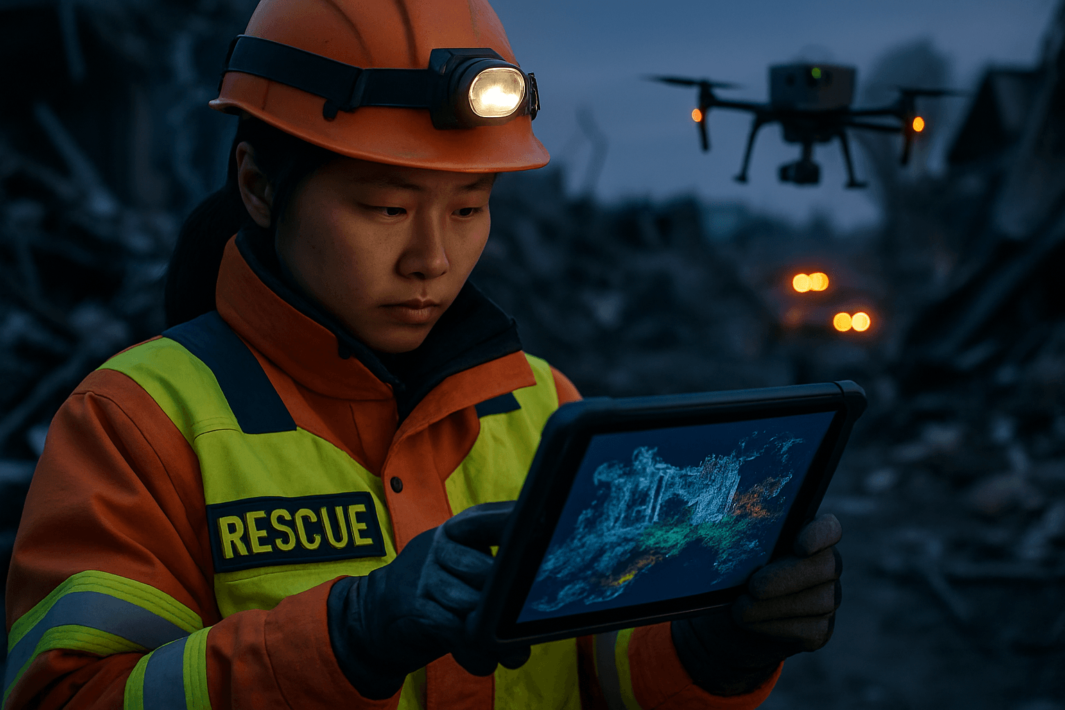
Drones equipped with LiDAR can quickly cover large areas, collecting vast amounts of data in a fraction of the time compared to ground-based methods. Some systems can provide real-time point cloud views, offering immediate situational awareness to operators and allowing for swift decision-making during critical times. This rapid response capability helps emergency responders make life-saving decisions quickly and accurately.
Enhanced Safety for Responders
Deploying drones to map dangerous or inaccessible areas significantly reduces the risk to human responders. Responders can assess situations from a safe distance, identifying obstacles, unstable terrain, and secure evacuation routes before entering the incident zone.
Cost-Effectiveness
Compared to traditional manned aircraft or extensive ground surveys, drone-based LiDAR solutions can provide faster insights at lower operational costs.
Key Components of a Drone LiDAR System for SAR
A robust drone LiDAR system designed for SAR missions typically integrates several sophisticated components:
- LiDAR Sensor (Laser Scanner): This is the core component that emits laser pulses and measures their return time. Modern sensors are increasingly compact, lightweight, and offer high point density and multiple returns per pulse, improving vegetation penetration. Examples include the DJI Zenmuse L2 and YellowScan Mapper+.
- Unmanned Aerial Vehicle (UAV): The drone platform must be stable, capable of carrying the LiDAR payload, and ideally offer features like extended flight times and robust navigation. Some advanced models include vertical take-off and landing (VTOL) and AI integration for autonomous operation.
- GNSS (GPS) Receiver: Provides precise global positioning data for the drone’s location. For survey-grade accuracy, Differential GNSS (D-GNSS), Real-Time Kinematic (RTK), or Post-Processed Kinematic (PPK) systems are preferred, as they reduce or eliminate the need for ground control points.
- Inertial Measurement Unit (IMU): Essential for precisely tracking the drone’s orientation (pitch, roll, yaw) and movement. The quality of the IMU directly impacts the accuracy of the resulting 3D model.
- Onboard Computer/Data Logger: Processes and stores the raw LiDAR, GNSS, and IMU data during the flight.
- High-Resolution Camera (Optional but Recommended): While not strictly part of the LiDAR system, integrating an RGB camera allows for colorizing the point cloud, providing better visual context and enhancing interpretability.
The Workflow: From Incident to 3D Map
The process of using drone-based LiDAR for rapid 3D mapping of SAR incident sites involves several critical steps:
1. Pre-Flight Planning and Risk Assessment
Before deployment, a thorough mission plan is developed. This includes defining the area of interest, setting flight parameters (altitude, speed, overlap), assessing airspace restrictions, and considering environmental factors like weather. Strategic flight planning is crucial to maximize data collection efficiency and ensure safety.
2. Data Acquisition (Flight Execution)
The drone is launched and flown autonomously or semi-autonomously over the incident site according to the pre-planned flight path. The LiDAR sensor continuously emits laser pulses, capturing millions of 3D points. Simultaneous data from the GNSS and IMU is also recorded to ensure each point is precisely georeferenced. Some systems can provide real-time point cloud data to the operator.
3. Post-Processing and Point Cloud Generation
Once the data is collected, specialized software is used to process the raw data. This involves:
- Point Cloud Generation: Combining the laser distance measurements with the drone’s precise position and orientation to create a dense 3D point cloud.
- Point Cloud Classification: Differentiating various features within the point cloud, such as ground, vegetation, buildings, and other objects. This allows for the creation of Digital Terrain Models (DTMs) that represent the bare earth, even under vegetation.
- Refinement and Filtering: Removing noise and correcting any inaccuracies in the data. Software like Trimble Business Center, LiDARMill, ArcGIS Pro, and Pix4D are commonly used for this.
4. 3D Model Creation and Analysis
The classified point cloud data is then used to generate various 3D products, including:
- Digital Elevation Models (DEMs): Representing the surface elevation.
- Digital Surface Models (DSMs): Including all features on the surface (buildings, trees).
- 3D Mesh Models: For more visually realistic representations.
These models can be analyzed to: - Assess Damage: Quickly evaluate the extent of destruction to infrastructure after events like earthquakes or floods.
- Identify Hazards: Pinpoint unstable structures, debris, or other dangers.
- Plan Rescue Routes: Determine the safest and most efficient paths for ground teams to access victims or critical areas.
- Locate Victims: In some cases, LiDAR can help detect human presence, especially when combined with other sensors like thermal imaging.
Applications in Disaster Management
Drone-based LiDAR’s rapid 3D mapping capabilities are applicable across a broad spectrum of disaster scenarios:
- Earthquake Damage Assessment: Quickly generating detailed 3D models to identify collapsed structures and prioritize rescue efforts.
- Flood Mapping: Creating high-resolution digital elevation models (DEMs) to predict flood patterns, measure water levels, and plan evacuation routes.
- Landslide Monitoring: Assessing terrain conditions and potential risks in areas prone to landslides.
- Wildfire Management: Mapping fire perimeters, assessing terrain for fire breaks, and identifying hotspots when integrated with thermal sensors.
- Accident and Crime Scene Reconstruction: Rapidly gathering comprehensive 3D data of incident scenes, which can be critical for investigations and swift clearance, especially on busy roadways.
Challenges and Limitations of Drone LiDAR in SAR
Despite its numerous advantages, drone-based LiDAR also presents some challenges:
- Cost of Equipment: While decreasing, LiDAR systems can still represent a significant investment compared to other drone-based mapping technologies.
- Data Processing Complexity: LiDAR generates very large datasets (point clouds) that require substantial computing power and specialized software for processing and analysis. Expertise is needed to classify data and recognize inconsistencies.
- Vegetation Penetration Limits: While superior to photogrammetry, LiDAR cannot “see through” extremely dense vegetation. If the canopy is too thick, the laser pulses may not reach the ground beneath.
- Accuracy Dependence: The accuracy of the output is highly dependent on the quality and calibration of the LiDAR scanner, IMU, and GNSS components.
- Environmental Factors: Adverse weather conditions, strong winds, and restricted airspaces can impact drone operations and data collection.
The Future of Drone-Based LiDAR in Search and Rescue
The integration of advanced Artificial Intelligence (AI) and machine learning (ML) is set to further enhance drone LiDAR’s capabilities. AI can assist in automated point cloud classification, object detection (such as identifying victims or specific hazards within complex scenes), and even autonomous mission planning. Miniaturization and increased efficiency of LiDAR sensors, coupled with real-time data processing capabilities, will continue to improve deployment speed and operational effectiveness. As the technology evolves, drone-based LiDAR will become an even more ubiquitous and indispensable tool, continually redefining the possibilities for rapid 3D mapping and situational awareness in critical search and rescue operations worldwide.


