Traditional surveying methods often grapple with challenges like inaccessible terrain, vast distances, and the need for specialized launch and landing infrastructure. However, a new class of unmanned aerial systems (UAS) is revolutionizing the field: hybrid Vertical Take-Off and Landing (VTOL) drones. These innovative aircraft combine the agility of multi-rotor drones with the endurance of fixed-wing aircraft, offering unparalleled benefits for long-range surveying missions across diverse industries.
What Are Hybrid VTOL Drones?
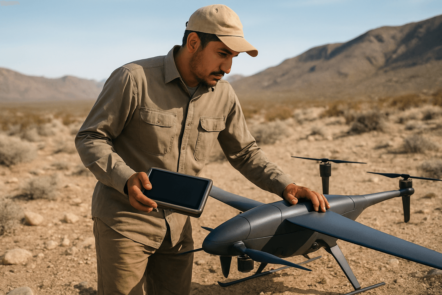
Hybrid VTOL drones are advanced unmanned aerial vehicles that integrate the best features of both rotary-wing and fixed-wing aircraft. They utilize propellers or tilt-rotors for vertical take-off and landing, much like a helicopter or multi-rotor drone, eliminating the need for runways or catapults. Once airborne and at a suitable height, they seamlessly transition into fixed-wing flight, where wings generate lift, allowing for efficient, high-speed horizontal travel over long distances. This dual functionality is often achieved through propulsion systems that combine electric motors for vertical lift and internal combustion engines or hybrid-electric systems for forward flight, extending range and endurance.
This unique design contrasts sharply with traditional drone types:
- Multirotor Drones: Excellent for hovering and precise maneuvering in confined spaces but are limited by shorter flight durations and reduced payload capacities due to high energy consumption.
- Fixed-Wing Drones: Highly efficient for long-distance flights and large area coverage, but typically require a runway or catapult for launch and recovery, restricting their operational environments.
Hybrid VTOL drones bridge this gap, offering a versatile solution that excels in both scenarios.
The Crucial Role of Long-Range Surveying
Long-range surveying missions are critical for a multitude of applications, including urban planning, infrastructure development, environmental management, and resource allocation. These missions involve gathering precise data over extensive areas, often in remote, rugged, or hazardous environments where traditional methods are time-consuming, costly, and sometimes dangerous. The data collected, such as high-resolution imagery, LiDAR scans, and multispectral data, is used to create detailed maps, 3D models, and Geographic Information Systems (GIS) databases, supporting informed decision-making.
Key Benefits of Hybrid VTOL Drones for Surveying Missions
The combination of VTOL and fixed-wing capabilities positions hybrid VTOL drones as an invaluable tool for modern surveying and mapping, providing a range of significant advantages.
1. Extended Endurance and Range
One of the most compelling benefits is their significantly extended flight time and operational range compared to multi-rotor drones. By leveraging the aerodynamic efficiency of fixed wings during horizontal flight, hybrid VTOL drones consume less energy, allowing them to cover vast areas in a single mission. Some models can achieve flight times of 1-3 hours, with certain specialized fixed-wing VTOLs reaching up to 10 hours of endurance under heavy load conditions. This is crucial for large-scale projects like mapping extensive agricultural fields, long pipeline inspections, or environmental monitoring of vast natural habitats.
2. Vertical Take-off and Landing (VTOL) Capabilities
The ability to take off and land vertically eliminates the need for runways, catapults, or large open spaces. This flexibility means hybrid VTOL drones can be deployed from and recovered in confined, challenging, or remote locations, such as dense urban environments, mountainous regions, forest clearings, or even ship decks. This greatly expands the operational footprint for surveyors, making previously inaccessible areas viable for drone-based data collection.
3. Enhanced Efficiency and Speed
Hybrid VTOL drones offer increased efficiency and speed in data collection. Their ability to transition to fixed-wing flight allows them to travel at higher speeds, covering more ground in less time than multi-rotor drones. This rapid data acquisition capability means projects can be completed faster, reducing fieldwork time and accelerating project timelines.
4. Versatility Across Terrains
The operational versatility of hybrid VTOL drones makes them adaptable to diverse environments, from open fields to urban areas and rugged landscapes. Whether a mission requires precise hovering for detailed inspections or rapid forward flight for expansive mapping, these drones can seamlessly switch between modes to suit the specific task. This adaptability reduces the need for multiple specialized drones, streamlining operations and potentially lowering overall costs.
5. Improved Data Quality and Accuracy
Equipped with advanced sensors like high-resolution cameras, multispectral sensors, and LiDAR scanners, hybrid VTOL drones can collect highly accurate and detailed data. Technologies like Real-Time Kinematic (RTK) and Post-Processed Kinematic (PPK) can further enhance GPS accuracy, allowing for centimeter-level precision in data collection, which is critical for detailed measurements and 3D modeling. This comprehensive data aids in creating precise topographic maps, digital elevation models (DEMs), and detailed 3D models for various applications.
6. Cost-Effectiveness
While the initial investment in hybrid VTOL drones might be higher than simpler multi-rotors, their operational efficiency and versatility can lead to significant cost savings in the long run. By reducing the need for manned aircraft, minimizing fieldwork time, and requiring less personnel, they lower overall operational expenses. Their ability to perform diverse missions also reduces the need for multiple specialized drones.
7. Safety Improvements
Deploying drones for surveying inherently improves safety by removing human personnel from potentially hazardous environments, such as steep slopes, remote wilderness, or active industrial sites. Hybrid VTOL drones, with their autonomous features, GPS navigation, and collision-avoidance systems, further enhance safety for both operators and the environment.
Applications in Long-Range Surveying and Mapping
Hybrid VTOL drones are transforming numerous sectors within surveying and mapping:
- Topographic Surveying and Large-Scale Mapping: Efficiently create detailed digital elevation models and contour maps of vast terrains for urban planning, construction, and land development projects.
- Infrastructure Inspection: Inspect extensive infrastructure like pipelines, power lines, railways, and bridges, accessing remote or hard-to-reach locations to detect defects and assess structural integrity without risking human safety.
- Agricultural Mapping and Precision Farming: Monitor large agricultural areas with high-resolution and multispectral sensors for crop health assessment, soil analysis, precision agriculture, and yield optimization.
- Environmental Monitoring: Conduct aerial surveys of forests, wetlands, and wildlife habitats, collecting data on vegetation health, biodiversity, and habitat encroachment for conservation efforts and environmental impact assessments.
- Mining Exploration: Assist mining companies in geological mapping, exploration, and site characterization over large concessions, identifying mineral deposits and potential hazards with greater efficiency and accuracy.
The Future of Surveying is Hybrid
Hybrid VTOL drones represent a pivotal advancement in unmanned aerial systems, offering a potent combination of endurance, versatility, and precision that fixed-wing and multi-rotor drones cannot match individually. Their capacity to execute long-range surveying missions with enhanced efficiency, safety, and data quality is making them an indispensable tool for surveyors, engineers, and environmental specialists worldwide. As technology continues to evolve, these drones are set to further revolutionize how we understand, map, and manage our physical environment, driving greater productivity and enabling more informed decision-making across critical industries.


