Humanity’s rich tapestry of history, woven into ancient ruins, historic buildings, and sacred landscapes, faces relentless threats from environmental decay, natural disasters, urban development, and illicit activities. Safeguarding these invaluable cultural heritage sites has traditionally been a monumental, often dangerous, and resource-intensive endeavor. However, the advent of Unmanned Aerial Vehicles (UAVs), commonly known as drones, is revolutionizing this critical field, offering a powerful, precise, and often non-invasive means to monitor, document, and protect our shared past.
The Growing Vulnerability of Global Heritage
Cultural heritage sites are finite and irreplaceable resources, essential for understanding human history, identity, and artistic achievement. Yet, these sites are increasingly vulnerable. Climate change-induced erosion, natural disasters like earthquakes and floods, and human-caused threats such as looting, vandalism, and unregulated construction pose constant dangers. Traditional methods of monitoring and documenting these vast and often remote locations are slow, costly, and can sometimes be intrusive, risking further damage to fragile structures.
How Drones Are Revolutionizing Site Protection
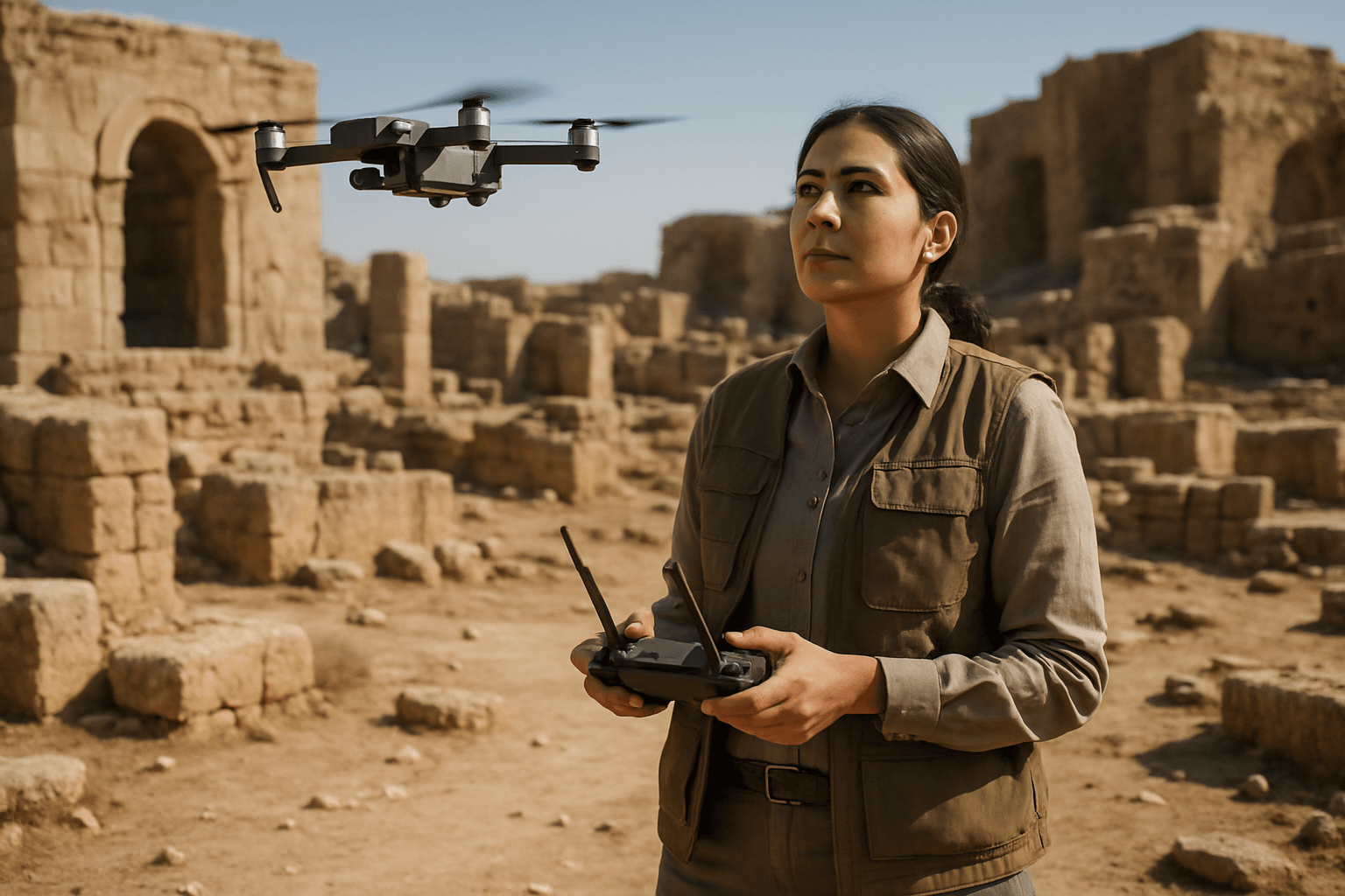
Drones equipped with advanced sensors and cameras have emerged as a versatile solution, providing heritage professionals with aerial perspectives and data collection capabilities previously unimaginable. These devices can reach areas difficult or impossible for humans to access, offering detailed insights without physical intervention.
Enhanced Surveillance and Monitoring
One of the primary applications of drones is for regular surveillance and monitoring of large or remote heritage sites. They can quickly cover vast tracts of land, identifying changes in the landscape, structural integrity of buildings, or potential signs of intrusion. High-resolution imagery captured by drones allows for detailed analysis of features like high-level wall tops and roof conditions, enabling proactive conservation measures.
Rapid Damage Assessment and Documentation
In the aftermath of natural disasters or acts of vandalism, drones can be deployed rapidly to assess damage without risking human lives. Their ability to quickly capture images and create 3D models allows heritage managers to understand the extent of damage and plan emergency conservation efforts efficiently. For example, drones were instrumental in rapidly assessing the damage and creating 3D models to guide restoration efforts following the devastating fire at Notre-Dame Cathedral in Paris. Similarly, during the 2016 earthquake in central Italy, the Italian National Fire Service extensively used drones to acquire crucial data on building conditions without exposing personnel to risks of structural collapse.
Deterring Vandalism and Illicit Activities
Beyond documentation, drones serve as a deterrent against looting, vandalism, and unauthorized encroachment. Regular aerial patrols by drones equipped with zoom cameras or thermal imaging can monitor large or secluded lands, helping to spot and respond to intrusions in real-time, even at night. This is vital for protecting sites from ongoing threats, especially in areas prone to such dangers.
Accessibility to Remote or Dangerous Areas
Drones eliminate the need for human personnel to access dangerous or hard-to-reach areas, such as unstable structures, cliffs, or remote archaeological sites, thereby improving safety for archaeologists and conservationists. Their non-invasive nature means they can collect data from a distance without disturbing fragile artifacts or structures, reducing the risk of accidental damage. Specialized drones, like the X500 research drone, can even navigate challenging underground environments with low light and obstacles, expanding accessibility to archaeological heritage.
Key Technologies and Capabilities for Drone Deployment
Modern drones are far more than just flying cameras; they are sophisticated platforms equipped with advanced sensing and processing capabilities.
High-Resolution Imaging and Thermal Sensors
Drones carry a wide variety of sensors, including high-resolution RGB cameras, multispectral imaging units, and LiDAR (Light Detection and Ranging) scanners. Thermal imagers detect heat retention differences, allowing archaeologists to identify subsurface features like buried foundations or artifact concentrations that are invisible to the naked eye. This non-destructive approach has led to discoveries such as previously undetected buildings at New Mexico’s Blue J site and an expansion of understanding of ancient settlements.
3D Modeling and Photogrammetry
One of the most powerful applications of drones is the creation of highly accurate and detailed 3D models and digital surface models of cultural heritage sites. By capturing thousands of overlapping still images, photogrammetry software (such as Structure-from-Motion, or SfM) processes these datasets to generate precise point clouds and geometrically corrected orthophotos. These 3D reconstructions are invaluable for detailed analysis, planning conservation work, and even creating virtual tours and educational resources. Countries like Cyprus have extensively used UAVs for 3D documentation and monitoring of archaeological sites.
AI-Powered Anomaly Detection
The future of drone deployment in heritage protection is increasingly intertwined with artificial intelligence (AI). AI-driven drones are transforming traditional surveillance by providing real-time data collection and analysis, advanced threat detection, and rapid response capabilities. AI can enhance defect detection accuracy and automate data processing, enabling predictive maintenance to identify potential issues before they become major problems. Embodied AI, which integrates perception, action, memory, and learning, promises to make drones even more adaptive, secure, and resilient in dynamic environments.
Autonomous Flight and Geofencing
Advances in drone technology allow for autonomous flight planning and execution, where drones can be programmed to follow specific routes and perform tasks independently. Geofencing capabilities can ensure that drones operate within designated safe zones, preventing accidental intrusion into sensitive areas while ensuring comprehensive coverage of the heritage site.
Benefits Beyond Security and Surveillance
The adoption of drone technology brings several significant benefits to the field of cultural heritage preservation that extend beyond direct security.
Cost-Effectiveness and Efficiency
Compared to traditional aerial photography involving helicopters or manned aircraft, or extensive ground surveys requiring large teams and scaffolding, drones offer a significantly more affordable solution. They reduce the need for expensive equipment and extensive labor, making advanced documentation and monitoring accessible to a wider range of heritage organizations. Their rapid deployment and ability to cover vast areas efficiently allow for more frequent monitoring and early detection of issues, preventing costly major repairs down the line.
Minimizing Human Risk
One of the most significant advantages is the drastic improvement in safety for personnel. Drones eliminate the need for human inspectors to physically access dangerous or difficult-to-reach areas, such as high roofs, fragile turrets, or confined spaces. This reduces the risk of accidents and injuries, protecting personnel and minimizing potential damage to the historical structures themselves.
Data Collection for Preservation and Education
Drones are invaluable for creating highly accurate and detailed records of cultural heritage sites, allowing professionals to track changes over time due to weather, vegetation growth, or human encroachment. This data is crucial for precise analysis, planning conservation work, and supporting restoration efforts. Moreover, the high-resolution imagery and 3D models generated by drones can be used to create virtual tours and educational resources, enhancing public engagement and fostering a deeper appreciation of cultural heritage. The digitization of sites, like the Philippine UNESCO-recognized Baroque Churches, using low-cost drones demonstrates a practical and viable approach to digital cultural heritage documentation.
Challenges and Ethical Considerations
Despite the numerous benefits, the widespread adoption of drones for historical site protection faces several important considerations.
Regulatory Hurdles and Airspace Restrictions
Operating drones requires strict adherence to local and federal aviation regulations. Many national monuments and historic sites have designated “no-drone zones” due to security concerns or the need to protect sensitive environments. Obtaining necessary permits and navigating complex regulatory landscapes can be challenging and time-consuming.
Privacy Concerns
The increasing use of drones also sparks significant concerns over privacy. The ability of drones to capture high-resolution imagery of individuals and private property raises ethical questions about surveillance and data collection, necessitating clear guidelines and responsible operation.
Technical Limitations and Training
While drone technology is rapidly advancing, limitations such as battery life can restrict extended surveillance missions, particularly for smaller models. Furthermore, accurately interpreting the vast amounts of data collected by drones, especially for complex and unique historical structures, requires specialized expertise and trained professionals. The potential for technical errors or loss of connection between the drone and pilot also poses operational safety risks.
Case Studies and Future Outlook
Drones are already making a tangible difference in cultural heritage protection worldwide:
- Cyprus and Egypt (Valley of the Kings) have utilized UAVs extensively for documenting and monitoring archaeological sites, creating detailed imagery and 3D models.
- In Bolivia, LiDAR-equipped drones helped uncover hidden burial mounds of the Casarabe culture, transforming what was once considered an unremarkable area into a significant archaeological discovery.
- Projects in New Mexico and Iraq have leveraged thermal and multispectral imagery from drones to detect subsurface archaeological features, revealing hidden architecture and settlement layouts.
- The Halmyris Citadel in Romania and Cala Castle in Spain have seen drone technology employed for 3D modeling and creating comprehensive databases for preservation and restoration planning.
Looking towards the future, drone technology holds the potential to further revolutionize conservation efforts. Continued advancements in AI will enhance data analysis, enabling predictive maintenance and more robust autonomous flight systems. The development of “swarm drones,” where multiple UAVs work collaboratively to inspect large structures, promises even greater efficiency. Integrating drones with other technologies like IoT and GIS will allow for real-time monitoring and proactive conservation measures, further safeguarding cultural heritage from threats. As drone technology continues to evolve, it promises to make cultural heritage preservation more sustainable, accessible, and effective for generations to come.


