In the wake of natural and man-made disasters, the clock begins ticking immediately. Critical decisions about search and rescue, resource allocation, and long-term recovery hinge on accurate and timely damage assessment. Traditional methods, often labor-intensive, time-consuming, and perilous for human responders, frequently fall short in providing the rapid, comprehensive overview needed. Enter the drone, or Unmanned Aerial Vehicle (UAV), a transformative technology revolutionizing post-disaster environmental monitoring and assessment.
The Imperative for Swift Assessment
Disasters leave landscapes scarred and infrastructures compromised, making affected areas difficult or even impossible to access by conventional means. Floods can submerge vast regions, earthquakes can render roads impassable, and wildfires can create hazardous air quality and unstable terrain. Under such conditions, ground teams face immense risks and significant delays in gathering crucial information. Rapid and precise damage assessment is paramount for several reasons: prioritizing search and rescue operations, understanding the full scope of environmental impact, informing immediate relief efforts, and laying the groundwork for resilient reconstruction and recovery.
How Drones Revolutionize Disaster Assessment
Drones offer a suite of advantages that directly address the limitations of traditional post-disaster assessment:
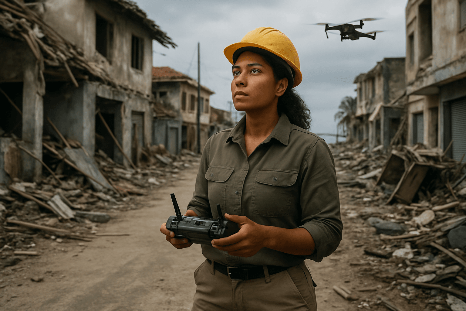
Enhanced Safety for Responders
Deploying drones minimizes the risk to human lives in hazardous environments, such as areas with radiation contamination, chemical spills, unstable structures, or active wildfires. Operators can control UAVs remotely from a safe distance, receiving real-time data without directly entering dangerous zones.
Unprecedented Speed and Accessibility
Unlike manned aircraft or ground teams, drones can be deployed rapidly and access remote, difficult-to-reach, or completely cut-off areas that are impassable due to debris, flooding, or other hazards. Vertical Takeoff and Landing (VTOL) drones, for instance, can cover large distances and assess situations even when all transportation routes are destroyed. This speed is crucial in the immediate aftermath of a disaster, when every second counts for search and rescue operations and initial damage assessment.
Superior Situational Awareness and Data Collection
Drones provide a “bird’s-eye view” of disaster-stricken areas, offering comprehensive visual data and real-time situational awareness. They can capture high-resolution images and videos, which can then be processed to create detailed maps and 3D models of affected regions. This data empowers first responders to make faster, more informed decisions and direct resources effectively.
Key Drone Technologies and Environmental Sensors
The versatility of drones in environmental damage assessment is largely due to the array of advanced sensors they can carry:
Visual (RGB) Cameras
These are standard high-resolution cameras that capture images and videos in the visible light spectrum, similar to the human eye. They are essential for general reconnaissance, mapping, and creating orthomosaics and 3D models of damaged areas and infrastructure.
Thermal Imaging and Infrared Sensors
These sensors detect heat signatures, allowing responders to identify hotspots from fires, monitor environmental hazards, and locate survivors even in challenging conditions like smoke, darkness, or under debris.
LiDAR (Light Detection and Ranging)
LiDAR technology uses laser pulses to measure distances and create highly detailed 3D maps and terrain models. It is particularly effective for assessing structural integrity of buildings, bridges, and power lines, and for mapping areas with dense vegetation or rugged landscapes where traditional imagery might be obstructed.
Multispectral and Hyperspectral Sensors
These advanced sensors capture data across multiple narrow bands of the electromagnetic spectrum, beyond what is visible to the human eye.
- Multispectral sensors are invaluable for analyzing vegetation health, detecting changes in plant stress, and monitoring water quality by identifying spectral signatures associated with different environmental conditions.
- Hyperspectral sensors offer even greater detail, measuring over 100 continuous bands to detect minute differences in spectral signatures, providing deeper insights into environmental changes.
Gas and Radiation Detectors
Drones can be equipped with specialized sensors to detect hazardous materials such as gas leaks, chemical spills, or even radiation levels after events like nuclear incidents. This capability is critical for assessing secondary hazards and ensuring the safety of communities and responders.
Assessing Diverse Environmental Impacts
Drones contribute to a comprehensive understanding of environmental damage across various domains:
Infrastructure and Urban Environments
Post-disaster, drones swiftly assess damage to buildings, roads, bridges, and utilities, helping engineers prioritize repairs and allocate resources effectively. They can create precise 3D models for detailed structural analysis, a process that would take weeks or months manually.
Natural Ecosystems and Landscapes
Drones monitor changes in terrain, such as those caused by landslides or mudslides, and assess the impact on vegetation, including deforestation, forest health, and crop damage. They can also track the spread of wildfires and identify potential hotspots.
Water Bodies and Hydrological Systems
In flood scenarios, drones map the extent of inundation, monitor water quality, and identify changes in river basins that could lead to further hazards. They can also assist in assessing damage to water infrastructure.
Hazardous Material Detection
Equipped with the right sensors, drones can detect gas leaks, chemical spills, and measure radiation levels, providing crucial data for containment efforts and protecting public health.
The Workflow of Drone-Based Assessment
The process of utilizing drones for post-disaster environmental assessment typically involves:
- Rapid Deployment: Quick launch of UAVs to the affected area.
- Data Acquisition: Drones fly pre-programmed or manually controlled paths, collecting high-resolution images, videos, and sensor data (thermal, multispectral, LiDAR).
- Real-Time Transmission: Data is often transmitted in real-time to command centers, providing immediate situational awareness.
- Data Processing and Analysis: Acquired data is processed using photogrammetry and AI-powered algorithms to generate detailed 2D maps, 3D models, digital elevation models (DEMs), and classification of damage types.
- Reporting and Decision Support: The analyzed data provides actionable insights for emergency managers, relief organizations, and recovery teams, guiding interventions and resource allocation.
Overcoming Challenges and Looking to the Future
While drones offer immense potential, their deployment in disaster zones faces several challenges:
- Regulatory and Legal Barriers: Navigating complex airspace regulations, restrictions on flying over certain areas, and privacy concerns regarding captured data can impede drone operations. Establishing pre-approved disaster management protocols and emergency-specific certifications can help streamline the process.
- Limited Flight Time and Battery Life: Current battery technology often restricts flight duration, impacting the ability to cover vast areas or conduct prolonged missions. Advancements like swappable battery systems, solar-powered drones, and autonomous charging stations are being explored.
- Data Overload and Processing Bottlenecks: Drones generate massive amounts of data, and processing this information quickly into actionable insights can be a challenge. The integration of Artificial Intelligence (AI) and machine learning algorithms is crucial for real-time data analysis and automating damage classification.
- Communication and Connectivity Issues: Damaged communication infrastructure in disaster zones can hinder drone control and data transmission. Satellite communication systems, mesh networks, and using drones as temporary communication relays are potential solutions.
- Weather Limitations: Adverse weather conditions like strong winds or heavy rain can limit flight capabilities.
The future of drones in environmental damage assessment is rapidly evolving. We can expect to see advancements in:
- Increased Autonomy and AI Integration: Drones will become even more autonomous, leveraging AI for dynamic pathfinding, obstacle avoidance, and on-board real-time data processing.
- Swarm Technology: Fleets of drones working collaboratively can cover larger areas and execute complex tasks more efficiently.
- Specialized Drones: Development of drones tailored for specific challenges, such as amphibious drones for water-based disasters or heavy-lift drones for carrying specialized sensors or small payloads.
- Predictive Analytics: Integrating drone data with machine learning models to predict potential disasters or secondary hazards, allowing for preemptive measures.
By continuously integrating these technological advancements and addressing operational challenges, drones are poised to play an increasingly vital role in safeguarding environments and assisting communities in building resilience against future disasters.


