Imagine a vast, shimmering ocean of solar panels stretching across the landscape, diligently converting sunlight into clean energy. Now, consider the monumental task of manually inspecting each individual panel, searching for invisible defects that could silently erode power output. This labor-intensive, time-consuming, and often hazardous endeavor was once the norm, costing millions and delaying critical repairs. Today, a new paradigm has emerged, transforming this challenge into an opportunity for unprecedented efficiency: the strategic deployment of Unmanned Aerial Systems, or drones, as the vigilant eyes of the renewable energy revolution.
The Imperative of Efficient Renewable Energy Monitoring
The global push for sustainable energy has led to an exponential increase in the deployment of renewable energy infrastructure, particularly large-scale solar farms. These sprawling installations, while vital for a greener future, present unique operational and maintenance (O&M) challenges. Ensuring their peak performance and longevity requires continuous, accurate monitoring.
The Evolving Landscape of Renewable Energy
Solar photovoltaic (PV) plants are central to the renewable energy transition. As these facilities grow in size and complexity, the need for sophisticated monitoring solutions becomes paramount. The sheer scale of utility-scale solar farms, often covering vast tracts of land, makes traditional inspection methods increasingly impractical.
Traditional Monitoring Challenges and Limitations
Historically, inspecting solar farms involved manual walkthroughs, visual checks, and ground-based electrical testing (like I-V curve tracing). These methods are plagued by several inefficiencies:
- Time-Consuming and Labor-Intensive: Manual inspections of thousands of panels can take days or even weeks, significantly impacting energy production due to downtime. A single technician might take 25 hours to inspect 1MW on foot.
- High Costs: The need for a large workforce and specialized equipment such as scaffolding or cherry pickers drives up labor and equipment costs. Traditional thermographic inspection costs can be cut by 30-40% using drones.
- Safety Risks: Technicians face inherent hazards, including working at heights, navigating challenging terrain, and exposure to electrical risks and extreme weather conditions.
- Inconsistent Data Quality: Human error and subjective assessments can lead to inconsistent results and missed defects, potentially allowing underperforming modules to persist for years.
- Limited Coverage: Manual inspections often only cover a small sample size (e.g., 10-25%) of modules due to time constraints, leading to a reduced understanding of the farm’s overall efficiency.
Common O&M issues in solar farms that can reduce efficiency include natural degradation, physical damage (cracks, loose connections), electrical faults (hot spots, overheating inverters, faulty cells, string errors, defective diodes), soiling (dust, dirt, bird droppings), shading from vegetation, and even damage from extreme weather or vandalism.
Drones: The Game-Changer for Solar Farm Inspections
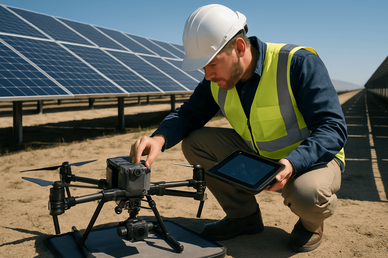
Unmanned Aerial Systems (UAS), or drones, have emerged as a transformative solution, directly addressing the limitations of traditional solar farm monitoring. Equipped with advanced sensors and powered by intelligent software, drones offer a faster, safer, and more accurate alternative.
Unparalleled Efficiency and Speed
Drones can drastically reduce inspection times, covering large areas quickly and thoroughly. For instance, a single UAV can inspect a solar farm up to 20 MW in a single day, while multi-drone systems can cover even larger utility-scale farms faster. One case study demonstrated a 400% improvement in efficiency, reducing inspection time from two months to just five days for 900,000 solar panels at the Mohammed bin Rashid Al Maktoum Solar Park. Drone inspections can be 70% faster than traditional methods and up to 97% more efficient, saving around $1254 per MW. This rapid capability allows for more frequent checks, ensuring issues are detected and addressed promptly.
Enhanced Safety Protocols
Drone inspections significantly improve safety by eliminating the need for personnel to physically access hazardous areas, such as rooftops or large fields with live electrical components. Operators can monitor from a safe distance, reducing risks associated with heights, electrical hazards, and harsh weather.
Comprehensive Data Acquisition
Modern drones, equipped with high-resolution cameras and various sensors, provide comprehensive data collection capabilities. This enables detailed insights into panel performance and allows for precise diagnostics and targeted maintenance, surpassing the detail achieved through manual inspections.
Advanced Drone Technologies for Precision Monitoring
The true power of drones in renewable energy monitoring lies in the sophisticated payloads they carry. These advanced technologies enable the detection of issues often invisible to the naked eye, providing critical data for predictive maintenance and operational optimization.
Thermal Imaging: Unmasking Hidden Defects
Thermal imaging, or infrared thermography, is arguably the most crucial technology for solar farm inspections. Drones equipped with thermal cameras can quickly scan vast areas to identify temperature variations that indicate underlying problems. These “hot spots” can signal a range of issues, including:
- Faulty Cells: Individual solar cells operating at different temperatures can indicate damage or reduced efficiency.
- Overheating Inverters: Inverters are critical components, and overheating can lead to significant power loss.
- Shading: Even subtle shading from vegetation or other structures can create temperature anomalies and reduce panel performance.
- Electrical Faults: Hot spots can indicate issues like cell damage, malfunctioning diodes, high resistance connections, or string outages, which can reduce energy production or pose fire hazards.
- Micro-cracks and Panel Degradation: Thermal imaging can detect subtle damage or degradation that is not visually apparent.
By identifying these thermal anomalies, operators can pinpoint faulty modules, allowing for early problem resolution, reduced downtime, and increased energy output.
Visual Inspection (RGB Cameras): Detailed Surface Analysis
High-resolution RGB (Red, Green, Blue) cameras capture detailed visual data, allowing for the detection of physical damage, dirt accumulation (soiling), loose connections, and other visible wear and tear. This complements thermal data by providing visual context for identified anomalies and helps in assessing the overall physical integrity of the installation.
LiDAR and Photogrammetry: Accurate Site Mapping and Topography
LiDAR (Light Detection and Ranging) technology, when integrated with drones, provides highly accurate 3D mapping and topographic surveying. By emitting laser pulses and measuring their return times, LiDAR can create detailed digital terrain models (DTMs) and digital surface models (DSMs), even penetrating dense vegetation to map the ground beneath. This is crucial for:
- Pre-construction Surveying: Accurate terrain models are vital for optimizing solar panel placement, accounting for slopes, and minimizing inter-row shading.
- Construction Progress Monitoring: 3D mapping can track construction progress and identify potential issues before they escalate.
- Environmental Assessment: LiDAR data can assist in monitoring vegetation encroachment around solar farms, which can cause shading and reduce efficiency.
- Digital Twin Creation: High-resolution imagery and LiDAR data facilitate the creation of digital twins, virtual replicas that enhance performance analysis and allow for simulations.
Photogrammetry, another drone-based mapping technique, uses overlapping images to create 3D models and orthomosaic maps, serving similar purposes in site planning and monitoring.
Beyond Inspection: Drone Applications Across the Renewable Energy Lifecycle
The utility of drones extends far beyond routine inspections, encompassing the entire lifecycle of a renewable energy project, from initial planning to ongoing operations and environmental management.
Pre-Construction Surveying and Site Selection
Before a single panel is laid, drones equipped with LiDAR and photogrammetry can perform detailed topographical surveys. This data is critical for site planning, optimizing panel layouts for maximum energy yield, and assessing potential environmental impacts. They provide precise data on terrain, slopes, and existing features, aiding in generic design for planning permissions and detailed build designs.
Construction Progress Monitoring
During the construction phase, drones offer an invaluable tool for progress tracking. Regular aerial surveys can provide an up-to-date visual record of the site, helping project managers monitor timelines, identify bottlenecks, and ensure construction adheres to design specifications.
Operational Performance Optimization and Predictive Maintenance
Once a solar farm is operational, drones become indispensable for maintaining peak performance. Regular thermal and visual inspections identify underperforming panels, hot spots, and other anomalies that can lead to significant energy losses. This data feeds into predictive maintenance programs, allowing operators to anticipate potential failures and schedule interventions before costly breakdowns occur, thereby extending asset lifespan and maximizing energy output. Automated flight patterns and advanced GPS positioning ensure consistent and repeatable inspection protocols for effective long-term monitoring.
Environmental Compliance and Vegetation Management
Drones are increasingly used for environmental monitoring around renewable energy sites. This includes assessing wildlife habitats, tracking vegetation changes around solar farms, and monitoring soil erosion. For solar farms, managing vegetation encroachment is crucial to prevent shading, which directly impacts panel efficiency. Drones can identify areas where vegetation needs to be cleared, contributing to both operational efficiency and environmental compliance. Solar-powered drones are even being explored for long-duration environmental monitoring tasks due to their extended flight times.
The Data Revolution: Analytics and Insights from Drone Operations
The sheer volume of data collected by drones necessitates advanced analytical capabilities to convert raw imagery into actionable intelligence. This is where cutting-edge software platforms and Artificial Intelligence (AI) play a pivotal role.
Software Platforms for Data Processing
After a drone mission, the collected visual and thermal imagery is uploaded to specialized software platforms. These platforms stitch together individual images to create comprehensive thermal maps and orthomosaic maps of the entire solar farm. This systematic processing allows for an aggregated view of the installation’s health.
AI and Machine Learning for Automated Anomaly Detection
Manually sifting through thousands of images for anomalies is a daunting task. This is where AI and machine learning algorithms revolutionize drone data analysis. AI-powered software can automatically detect and classify various defects, such as cracks, hot spots, soiling, shading, and even potential fire hazards. They can analyze past performance, weather trends, and equipment behavior to predict potential failures. Some systems can even identify specific module numbers and their precise GPS coordinates for targeted repairs.
Actionable Intelligence for Asset Managers
The output of drone data analysis is comprehensive reports detailing identified anomalies, their severity levels, and precise location coordinates. This actionable intelligence empowers solar farm owners and O&M service teams to make informed decisions regarding maintenance, repairs, and optimization strategies. By providing early warnings, these systems minimize repair costs and prevent potential failures, leading to significant cost savings and optimized energy production.
Navigating the Future: Challenges and Opportunities
While drones offer immense advantages, their widespread adoption in renewable energy monitoring also presents challenges that require careful navigation and continuous innovation.
Regulatory Frameworks and Compliance
Drone operations are subject to evolving legal and regulatory requirements, which vary significantly by jurisdiction. In the U.S., commercial drone operators must obtain a Part 107 certification from the FAA. Regulations often include visual line of sight (VLOS) requirements, altitude limitations, no-fly zones, and privacy concerns when capturing imagery in populated areas. Adhering to these regulations is crucial for legal compliance, safe operations, and maintaining public trust. Standardization of regulations across borders would further streamline operations and encourage adoption.
Skill Development and Training
Operating advanced inspection drones and interpreting their data requires specialized skills and technical training. Operators need expertise in thermography science, flight planning, drone safety, and sensor selection. As the technology evolves, continuous training and skill development are essential for the workforce to effectively leverage drone capabilities.
Integration with Existing O&M Workflows
Seamless integration of drone-based inspection data into existing Operations and Maintenance (O&M) workflows and asset management platforms is key to maximizing their value. This requires robust data management systems and compatible software solutions that can process, analyze, and present drone data in an easily digestible format for maintenance teams.
The economic benefits are clear: drone inspections can lead to cost reductions of 40-60% compared to traditional methods, with some studies showing savings of over $1,915 per MW. This includes reduced labor costs, minimized downtime, and proactive issue detection, preventing larger, more expensive repairs. The investment in drone hardware and software, while significant (e.g., a high-quality thermal inspection drone and sensor can cost around $24,500, with total investment exceeding $30,000 for equipment, training, and software), quickly yields a substantial return on investment.
The integration of Unmanned Aerial Systems into the renewable energy sector represents a pivotal shift, ushering in an era of unprecedented efficiency, safety, and data-driven decision-making. As solar farms continue to proliferate and our reliance on clean energy grows, drones will not merely be tools but indispensable partners in optimizing performance, ensuring longevity, and accelerating our transition to a sustainable future.


