Drone thermal photography is revolutionizing industries, providing insights invisible to the naked eye. By capturing infrared radiation, these specialized drones reveal temperature variations, unlocking a world of applications from search and rescue to building inspections. This guide delves into the core of drone thermal photography, exploring its technology, applications, and how to get started.
What is Drone Thermal Photography?
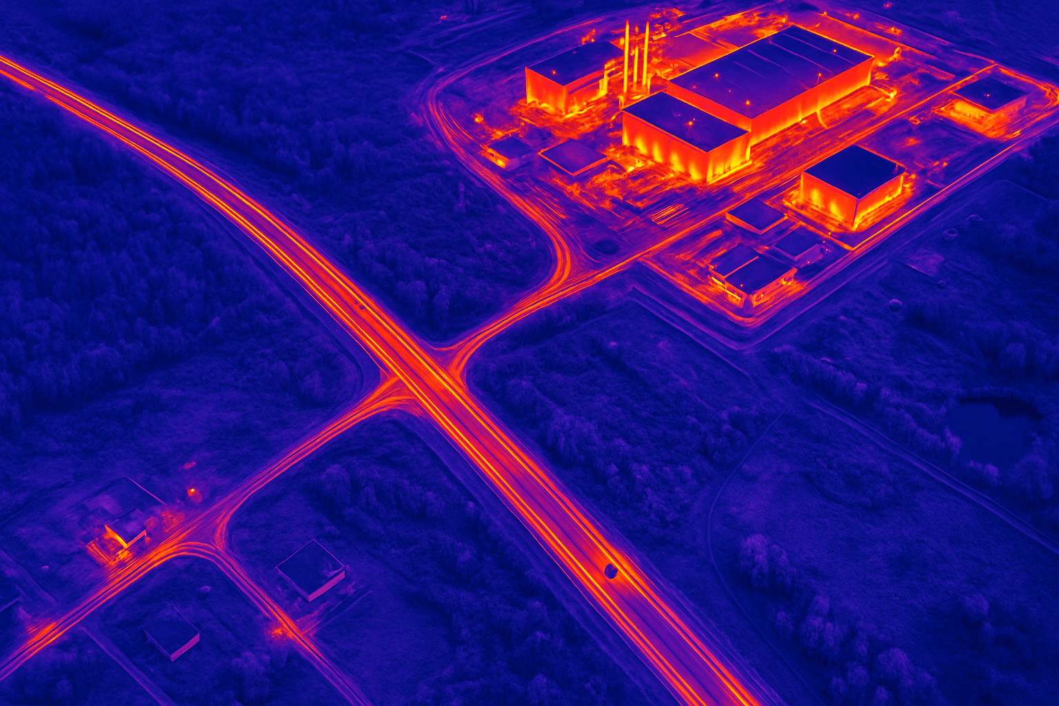
Thermal drone imaging is the process of capturing infrared radiation using a drone-mounted thermal camera. Unlike standard drones equipped with RGB (red, green, blue) cameras that see the world as we do, thermal drones visualize temperature differences in the environment. Everything with a temperature gives off infrared radiation. Thermal cameras detect this radiation and translate it into images where warmer areas appear brighter and cooler areas darker, or vice versa, depending on the color scale used.
Also known as thermography or infrared imaging, it captures images based on infrared radiation, a form of heat energy that all objects emit. When this technology is used with drones, it enables the capture of thermal data from above, providing a unique perspective that isn’t possible with traditional imaging methods.
How Do Thermal Drones Work? The Science Behind the Image
Thermal cameras, also known as thermographic cameras or infrared (IR) cameras, are sophisticated devices designed to detect and visualize heat radiation emitted by objects. Unlike traditional cameras that capture visible light, thermal cameras operate within the infrared spectrum. This capability allows them to perceive temperature variations that are invisible to the human eye.
Here’s a breakdown of the key components and processes:
- Infrared Radiation: Objects with a temperature above absolute zero (-273.15 degrees Celsius) emit infrared radiation. The amount of this radiation increases with the temperature of the object.
- Thermal Camera: Mounted underneath or integrated into the drone, the thermal camera detects heat (infrared radiation) instead of visible light.
- Microbolometer: At the heart of a thermal imaging camera lies a specialized sensor known as a microbolometer. This sensor consists of thousands of tiny thermal detectors that convert infrared radiation into electrical signals. The camera then processes these signals to generate a visual representation of the temperature distribution across a scene.
- Image Processing: The image processor converts the heat signatures into a digital image displayed on a screen. Each pixel in the image corresponds to a specific temperature value. Higher-end thermal cameras also include radiometric data, meaning they capture exact temperature readings for every point in the image.
- Real-time Streaming: While the drone flies, it streams the thermal feed live to your remote controller, tablet, or ground station. Many systems allow you to switch between RGB and thermal views, adjust the color palette, or even overlay the two images in real time.
- Color Palettes: Using thermal imaging software users can change the palette of colors used to represent the heat of the scene. Each view is useful for picking various details out of the image, and these options include:
- White Hot: Hotter objects appear lighter, and colder areas are darker.
- Black Hot: The opposite of hot white, with hotter objects appearing darker.
- Rainbow: Temperature corresponds to hues, with warm colors representing heat.
Factors Affecting Thermal Image Quality
How far can thermal drones “see”? Thermal cameras don’t “see” in distance the way optical cameras do—they detect radiated heat. A thermal drone can detect temperature differences at a distance, but image quality depends on:
- Sensor resolution. Higher resolution means more detail.
- Lens type (field of view)
- Altitude and flight angle.
- Proximity: Close proximity enables high-resolution, detailed images.
- Angle of the drone: The angle of the drone can affect how heat is perceived. An oblique angle might skew readings, while a direct, overhead angle offers the most accurate temperature representation.
- Environmental Conditions: Conditions like wind, rain, and sunlight can affect temperature readings. Calm, overcast days provide the most accurate thermal data.
- Target Surface: The smoothness or roughness of the target surface can reflect or absorb heat differently, affecting the accuracy of temperature readings.
Key Features to Consider in a Thermal Drone
- Resolution: For basic inspections, look for cameras with at least 160×120 resolution. Entry-level radiometric sensors (which record temperature values per pixel) start at 320×240.
- Dual Sensors: Many thermal drones include both a thermal and standard camera. This lets you overlay or compare images for clearer context. Drones fitted with dual sensors can generate both thermal and conventional images for a better overview of the scene
- Flight Time: Look for drones with at least 20–30 minutes of flight time per battery.
- Autonomous Flight Modes: Autonomous flight modes, GPS hold, and obstacle avoidance make flying smoother and safer—especially if you’re multitasking with thermal views.
- Radiometric Functionality: For precise thermal inspections, drones with radiometric functionality can measure and display the temperature for each pixel in an image.
- Gimbal Stabilization: Typically, the camera is mounted on a gimbal when attached to a drone. When an infrared camera is mounted on a drone, the device is typically placed on a gimbal, which stabilizes the image and lets the lens rotate a full 360 degrees.
Why is Drone Thermal Imaging Important?
Drone Thermal Imaging offers several significant benefits:
- Night Vision: Since thermal cameras rely on heat signatures instead of visible light, they can operate in total darkness, making them perfect for nighttime operations.
- Detect Hidden Objects: Thermal imaging can detect objects and people obscured by light foliage or smoke due to the heat they emit.
- Monitor Temperature: Thermal imaging allows for remote temperature monitoring, benefiting various industrial applications.
- Improved Safety: Drones can safely inspect dangerous or hard-to-reach areas, minimizing risks to personnel.
Applications of Drone Thermal Photography: Where’s the Heat?
Drones with thermal cameras are a powerful tool for capturing and interpreting thermal data across various applications and industries from structural inspections to aerial surveillance, or search and rescue missions.
- Search and Rescue: One of the most common uses of thermal drones is as firefighting tools. Heat mapping from the air allows firefighters to get ahead of risk factors. Fires aren’t the only types of disasters where thermal drones can assist rescue crews. Thermal drone imaging can help locate missing persons in adverse conditions, such as darkness, dense forests, or areas covered with smoke or debris.
- Building Inspections: Thermal drones excel at detecting energy inefficiencies in buildings. They can visualize heat loss through walls, roofs, and windows, helping teams identify insulation gaps and air leaks. Thermal imaging can reveal heat loss areas, dampness, and structural issues in buildings that are not visible to the naked eye. Municipalities have used this technology to target retrofitting projects, optimize energy use, and achieve significant cost savings. From residential houses to large commercial buildings, roofs need frequent inspection for detecting inefficiencies from things like heat leaks. Drone thermal cameras can help detect these to make sure roofs stay in top shape and free of critical safety hazards.
- Power Line Inspections: Inspecting utility infrastructure, from plants and solar panel installations to far-flung power lines, is easier with drones. Power grids are prone to faults like overheating connections, corrosion, and overloading—issues that are invisible to standard cameras.
- Advanced Agriculture: Monitoring crops and grazing herds from the air is a potentially overlooked use for drones. Thermal imaging lets farmers measure fields’ heat exposure and track animals, even at night. Ongoing efforts to make farming more efficient through technology deployment are a perfect match for drone deployment. A thermal camera for drone can detect irrigation issues, pest infestations, and plant diseases before they become visible to the naked eye. By spotting dry areas or unhealthy plants, farmers can adjust their irrigation systems and apply treatments exactly where needed.
- Pipeline Monitoring: Subtle temperature anomalies in pipelines indicate leaks, blockages, or insulation issues.
- Road and Bridge Analysis:
- Solar Panel Maintenance: Thermal imaging can detect defective solar panels underperforming due to damage or dirt.
- Aerial utility and mine drone inspections: No matter how large a plant or mine is, drones can fly over the site and take readings.
- Oil refineries: Oil refineries employ thermographic imaging drones to sense the relative energy being generated in different parts of their plant infrastructure. This allows inspectors to get a clear image of the status of equipment, without forcing employees to get close to potentially dangerous areas.
- Wildlife Monitoring: Thermal drones can be used to monitor wildlife populations, track animal movements, and detect poaching activities.
- Law Enforcement: Law enforcement agencies use thermal drones for search and rescue operations, surveillance, and crime scene investigations.
- Environmental Monitoring: Thermal drones can be used to monitor environmental changes, such as deforestation, pollution, and volcanic activity.
Getting Started with Drone Thermal Photography
- Training and Certification: Consider getting certified in thermography to enhance your skills and credibility.
- Equipment Selection: Choose a drone and thermal camera that suits your specific needs and budget.
- Software for Thermal Imaging Analysis:
- First Flight Tips:
- Define clear mission objectives
- Flight planning is the next critical step. Use automated flight tools like Dronelink to create uniform flight grids.
- Conduct flights during optimal conditions, such as early mornings or evenings, when temperature contrasts are most visible.
- Maintain an altitude between 20 and 120 meters and ensure overlap for accurate orthophotos. Note that the image resolution in thermal cameras tends to be lower than in regular cameras, so making sure that the flight paths have enough overlap is vital.
- Real-time monitoring allows teams to address any issues immediately.
Setting Up Thermal Cameras on Drones
Setting up thermal cameras for drone operations involves careful selection, configuration, and planning to ensure the accuracy and quality of the data collected. Start by choosing a high-quality thermal camera that matches the needs of your project. Cameras with at least 640×512 resolution and <50 mK sensitivity ensure detailed, actionable results. Popular options include the FLIR Vue Pro R and DJI Zenmuse H20T. Equally important is ensuring your drone can handle the camera’s payload. Platforms like the DJI Matrice Series provide robust lifting capabilities, while drones like the DJI Mavic 3 Thermal offer compact, cost-effective solutions. Once the equipment is ready, configure and calibrate the thermal camera to match your mission parameters. Calibration ensures accurate temperature readings, and settings like emissivity, reflectivity, and temperature range must align with the monitored materials. For instance, detecting pipeline leaks may require setting the range between 0°C and 150°C.
UK Drone Laws and Regulations
Current Drone regulations in the UK in 2025 are based on the guiding principle that “UAS operating in the UK must meet at least the same safety and operational standards as manned aircraft when conducting the same type of operation in the same airspace” (CAP 722 – Unmanned Aircraft System Operations in UK Airspace – Guidance).
Here’s a summary of key UK drone laws and regulations as of 2025:
- Registration: In the UK, drones weighing over 250 grams need to be registered with the Civil Aviation Authority (CAA). To register your drone, visit the CAA’s dedicated Drone and Model Aircraft Registration and Education Service (DMARES) website. The registration process involves providing your personal details and getting a unique Operator ID, which must be displayed clearly on your drone.
- Operator ID and Flyer ID: When you register with the CAA, you’ll receive an Operator ID and a Flyer ID. The Operator ID is required for the person or organisation responsible for the drone, while the Flyer ID is needed for anyone who intends to fly the drone. It’s crucial to have these IDs readily accessible when flying your drone.
- Age Restrictions: The legal age for operating a drone in the UK is 18 years or older. Younger individuals can only operate drones under the direct supervision of an adult.
- Altitude Limit: Drones must not be flown above 400 feet (120 meters) above ground level.
- Distance from People and Property: Make sure to keep your drone at least 50 meters away from people and properties not under your control, and 150 meters away from gatherings of 1,000 or more people.
- Visual Line of Sight: Maintain a visual line of sight with your drone at all times while flying.
- No-Fly Zones: Be aware of no-fly zones, such as airports and restricted areas, where drone flight is prohibited. Flying drones within 5 kilometers of an airport or airfield boundary is strictly prohibited unless you have received permission from the airport or air traffic control.
- Privacy: It’s important to respect individuals’ privacy when flying your drone. Do not capture or distribute images or videos without their consent, and avoid recording in areas where privacy is expected, such as private gardens. It


