The mining industry, traditionally reliant on labor-intensive and time-consuming methods, is undergoing a significant transformation with the integration of Unmanned Aerial Systems (UAS), commonly known as drones. These advanced aerial platforms are proving to be indispensable tools for a multitude of applications, with volume calculation standing out as a critical area of impact. By providing rapid, accurate, and safe data collection, drones are fundamentally changing how mining operations manage their valuable resources and optimize efficiency.
The Critical Need for Accurate Volume Calculation in Mining
Accurate volume calculations are paramount in mining operations for several key reasons. They are essential for inventory management of stockpiles (e.g., ore, waste, aggregates), tracking material movement, assessing production output, and ensuring compliance with financial reporting and regulatory standards. Without precise data, mining companies face challenges in resource allocation, cost estimation, and overall operational planning, potentially leading to significant financial discrepancies and inefficiencies.
Traditional methods for calculating volumes, such as ground-based surveys using total stations or GPS equipment, are often slow, labor-intensive, and can pose considerable safety risks to personnel, particularly in hazardous or inaccessible areas of a mine site. These methods can take days or even weeks to complete for large areas, limiting the frequency of measurements and potentially leading to outdated inventory figures.
How Drones Revolutionize Volume Measurement
Drones equipped with advanced sensors and cameras are transforming volume calculation in mining by offering a faster, safer, and more accurate alternative to traditional techniques. The process typically involves several key steps:
Data Capture: Photogrammetry and LiDAR Technology
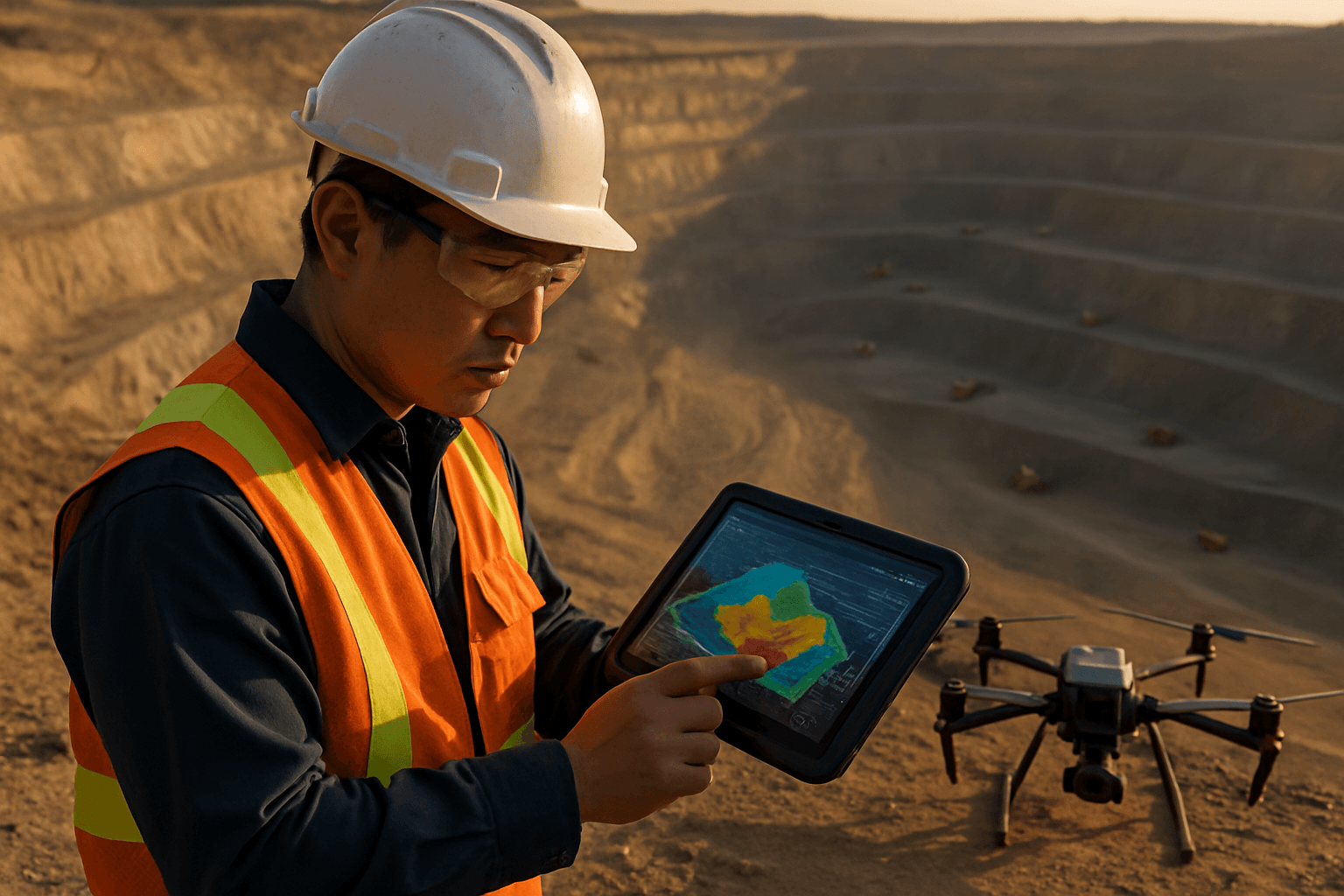
The initial phase of drone-based volume calculation involves capturing highly detailed aerial data of the area of interest. Two primary sensor technologies are employed for this purpose:
- Photogrammetry (Optical/RGB Cameras): Drones equipped with high-resolution optical cameras capture a series of overlapping images of the stockpiles or terrain. This imagery serves as the foundation for creating accurate 3D models. The density of data points generated through photogrammetry is significantly higher than traditional methods, leading to more precise representations of irregular stockpiles.
- LiDAR (Light Detection and Ranging) Sensors: LiDAR sensors emit laser pulses to measure distances, generating precise 3D point clouds. This technology is particularly effective for capturing accurate elevation data, even in challenging environments with vegetation or obstructions, as it can penetrate through them to map the ground surface.
Data Processing: From Images to 3D Models
Once the aerial data is collected, it is imported into specialized photogrammetry or LiDAR processing software. This software uses sophisticated algorithms to stitch the overlapping images or process the point cloud data, transforming raw information into usable 3D models, orthomosaics, and digital elevation models (DEM), digital terrain models (DTM), or digital surface models (DSM).
Volume Calculation: Leveraging 3D Models
With the 3D model generated, volumetric measurements can be performed directly within the software. Users can define the base and boundaries of the stockpiles or excavated areas, and the software then calculates the volume by considering the vertical distance from the base to each point in the designated area. This allows for various types of measurements, including:
- Stockpile Volume: Calculating the total volume of material in a given stockpile.
- Cut and Fill Volumes: Determining the amount of material that needs to be removed (cut) or added (fill) for a specific area, crucial for tracking project progress and planning logistics.
- Delta (Difference) Calculations: By conducting multiple flights over time, the software can compare volumes between two surfaces, enabling precise tracking of material movement, development, or subsidence.
Key Advantages of Drone-Based Volume Calculations
The adoption of drones for volume calculations in mining offers a multitude of benefits that significantly enhance operational efficiency and safety:
Enhanced Accuracy and Precision
Drones can capture highly detailed data, leading to significantly more accurate volume calculations compared to traditional methods. Studies show that drone-based measurements can achieve accuracy within 1-3% of traditional laser systems, and even as high as 1% margin of error in some cases. This precision is crucial for financial reporting, inventory management, and optimizing resource utilization.
Technologies like Real-Time Kinematic (RTK) GPS and Ground Control Points (GCPs) further enhance positional accuracy, ensuring centimeter-level precision for the generated data.
Increased Efficiency and Speed
Drone surveys drastically reduce the time and effort required for data collection. Tasks that might take ground teams weeks or months can be completed in a matter of hours or days. For instance, a large quarry mapping that typically takes two surveyors over 12 hours can be completed in 2-3 hours with drones. This speed allows for more frequent surveys, providing up-to-date records of stockpiles and site progress, enabling better-informed decision-making.
Improved Safety
One of the most significant advantages of using drones is the enhanced safety it provides for mine personnel. Drones can access hazardous and hard-to-reach areas, such as unstable stockpile slopes, active blast zones, or high-walls in open-pit mines, without putting human lives at risk. This reduces the risk of accidents and injuries, making the workplace safer.
Cost-Effectiveness
While there is an initial investment in drone technology and software, the long-term cost savings are substantial. Drones minimize costs associated with labor, equipment, and traditional aerial survey methods that often require expensive aircraft. Some reports indicate that drone aerial survey costs can be cut by up to 90%.
Comprehensive Data and Analysis
Beyond just volume calculation, drone surveys generate rich datasets that can be used for various other mining applications, including:
- 3D Modeling and Mapping: Creating detailed 3D models and topographic maps of the entire mine site.
- Site Monitoring: Tracking changes over time, identifying potential issues like unstable zones or landslide areas, and monitoring work areas to ensure operations stay within designated zones.
- Design and Planning: Providing aerial maps for designing new operations, optimizing exploitation routes, and planning for drilling and blasting.
- Environmental Monitoring and Land Rehabilitation: Assisting in monitoring water and air quality, and tracking progress during mine closure and land rehabilitation efforts.
- Inventory Management: More reliable inventory numbers can significantly reduce future write-offs, boosting efficiency and profitability.
Software Solutions for Drone Volumetric Measurements
A variety of specialized software platforms are available to process drone data and perform volumetric calculations. Popular choices in the mining industry include:
- Pix4D: Known for its robust photogrammetry capabilities, converting aerial images into precise 3D models and orthomosaics for accurate volume calculations.
- Agisoft Metashape: Another widely used photogrammetry software that processes aerial images into 3D models suitable for volumetric analysis.
- DroneDeploy: A cloud-based platform offering user-friendly tools for mapping and volumetric analysis with automated workflows and customizable reporting.
- Propeller Aero: Specializes in drone data processing and cloud-based software, automating stockpile volume calculations with high precision and offering real-time data access.
- Other solutions: Software like Cloud Compare and various GIS tools also facilitate volumetric analysis and integration of drone data into broader mine planning systems.
The Future of Volume Calculation in Mining
The integration of drones for volume calculations represents a significant leap forward for the mining industry. As drone technology continues to advance, including improvements in sensor capabilities and AI integration for automated data analysis, their role in optimizing mining operations will only grow. This transformative technology is enabling mining companies to achieve unparalleled efficiency, accuracy, and safety, making it an indispensable tool for modern resource management.


