In the chaotic aftermath of natural disasters or other catastrophic events, every second counts. Traditional methods of assessing damage and locating survivors are often slow, resource-intensive, and inherently dangerous for human responders, leading to increased casualties and delayed recovery efforts. However, a transformative technology is rapidly changing this grim reality: Unmanned Aerial Systems (UAS), commonly known as drones. These versatile machines are becoming indispensable tools, offering an unprecedented ability to rapidly assess devastation, pinpoint casualties, and provide critical real-time intelligence that empowers swift and effective disaster management.
The Evolving Role of Drones in Disaster Response
The integration of drones into emergency management protocols marks a significant leap forward, offering capabilities that traditional methods simply cannot match. Their ability to quickly deploy and navigate hazardous or inaccessible terrains makes them invaluable in the initial hours and days following a disaster.
Immediate Advantages of UAS
Drones offer numerous benefits, improving the speed, safety, and effectiveness of disaster response:
- Faster Response Times: Drones can be deployed rapidly, much quicker than manned aircraft or ground teams, allowing for immediate assessment of vast areas. This speed is crucial for initiating search and rescue operations and prioritizing resource allocation.
- Increased Safety for Responders: By providing aerial views of disaster zones, drones minimize the need for human responders to enter potentially unstable or contaminated environments, significantly reducing risks. During the Fukushima Daiichi nuclear disaster in 2011, drones were used to survey the extent of damage without endangering relief workers.
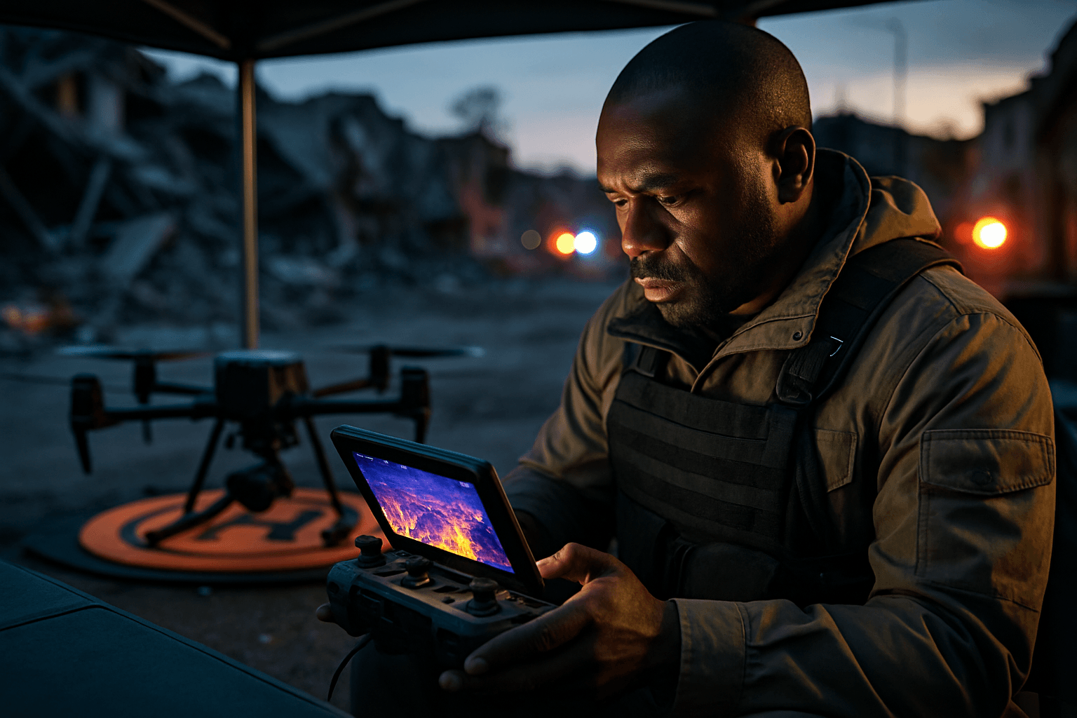
- Real-time Situational Awareness: Equipped with advanced cameras and sensors, drones deliver critical real-time data and high-resolution imagery to first responders, enabling them to make informed decisions and direct resources effectively. This immediate insight helps identify collapsed buildings, blocked roads, and other areas of concern.
- Cost-Effectiveness: Drones offer a lower-cost alternative to traditional aerial surveys using manned aircraft, reducing operational expenses for disaster response efforts.
Overcoming Traditional Challenges
Disasters often disrupt communication networks and render vast areas inaccessible. Drones can overcome these logistical and physical barriers, reaching areas that are difficult or impossible for ground teams, such as flooded houses, debris-covered streets, or impenetrable thickets. They can also deliver vital supplies, like medical aid or communication equipment, to isolated communities.
Drone Applications in Post-Disaster Damage Assessment
One of the primary uses of drones post-disaster is their ability to conduct rapid and accurate damage assessments, which is crucial for planning recovery and reconstruction.
Rapid Mapping and Surveying
Drones excel at surveying and collecting data after a disaster, creating detailed maps and 3D models of affected areas. This high-resolution data helps identify damaged areas, assess the extent of the damage, and plan the reconstruction process. For example, during Hurricane Harvey in 2017, drones were extensively used to map flood damage in Houston. The collected data can be processed into orthomosaics, digital terrain models, and point clouds, providing comprehensive insights for urban planners and engineers.
Structural Integrity Evaluation
Drones equipped with advanced imaging and LiDAR (Light Detection and Ranging) technology can be used to inspect critical infrastructure like bridges and power lines to determine their safety for use. They can identify structural damage such as concrete cracking, spalling, and exposed rebar, and even detect nonstructural damage like façade collapse through 3D point cloud change detection. AI-powered systems can analyze drone footage to classify building and road damage rapidly, assessing thousands of buildings in minutes, a task that would take weeks or months manually.
Infrastructure Inspection
Beyond buildings, drones can inspect roads and other infrastructure, identifying blocked routes and potential hazards. AI tools can even generate Google Maps-style route planners to help responders navigate around damaged areas.
Enhancing Casualty Identification and Search & Rescue Operations
Drones have revolutionized search and rescue (SAR) missions, providing critical assistance in locating missing persons and identifying casualties in challenging environments.
Thermal Imaging and Life Detection
A key capability is the use of thermal imaging cameras, which detect infrared radiation emitted as heat. This allows drones to “see” through darkness, smoke, fog, and even light foliage, making them invaluable for locating individuals trapped under debris or in remote areas, especially at night. The ability to detect heat signatures against cooler backgrounds significantly improves the chances of finding survivors, even if hidden from the naked eye. While the heat of bleeding can cool quickly, continuous bleeding from an open wound may still be detectable by thermal cameras.
Real-time Situational Awareness
Drones provide real-time aerial reconnaissance, allowing SAR teams to quickly survey large areas, pinpoint potential subject locations, and identify hazards and escape routes. This immediate visual data aids in tactical planning and helps prioritize search efforts. Case studies demonstrate the life-saving role of thermal drones, such as locating a sleepwalking child in dense woods by detecting her heat signature.
Delivering Critical Supplies and Communications
In addition to searching, drones can quickly and safely transport essential supplies like medical aid, food, and communication equipment to areas difficult to reach by traditional means. Furthermore, AI-integrated drones can act as temporary communication relays, restoring connectivity in areas where traditional networks have failed, facilitating coordination among response units and allowing survivors to communicate.
Key Technologies Powering Disaster Drones
The effectiveness of drones in disaster management is underpinned by a confluence of advanced technologies.
Advanced Sensors and Cameras
Modern disaster drones are equipped with high-resolution cameras, thermal sensors, and LiDAR. These sensors enable them to capture detailed visual and thermal data, create precise 3D models, and penetrate dense vegetation or smoke. Some commercial drones, like the DJI Matrice 300 RTK, are designed to carry multiple payloads, offering impressive flight times suitable for surveying large affected areas.
AI and Machine Learning for Data Analysis
Artificial intelligence (AI) and machine learning (ML) are pivotal in transforming raw drone data into actionable intelligence. AI algorithms can rapidly process aerial imagery, detect changes in terrain, identify affected areas, and even classify types of damage. Systems like CLARKE, developed at Texas A&M University, use AI to assess damage to buildings, roads, and infrastructure in minutes, generating heat maps and prioritizing zones for urgent attention. AI can also analyze vital signs data collected by drones to determine health risk status of people in disaster zones, guiding first responders to those in most immediate need.
Swarm Robotics and Autonomous Navigation
The future of disaster response increasingly points towards autonomous drones and swarm robotics – multiple UAS working in coordination. Autonomous drones can navigate complex environments and optimize flight paths dynamically, even in hazardous conditions. Swarms can cover larger areas than single drones, enhancing efficiency and continuous coverage. GPS-based autopilot systems further increase efficiency and reduce risk to human teams.
Challenges and Future Outlook
Despite their immense potential, integrating drones into disaster management faces several challenges.
Regulatory Hurdles and Airspace Management
One of the foremost challenges is navigating complex regulatory frameworks and airspace restrictions. During emergencies, Temporary Flight Restrictions (TFRs) are often issued around affected areas to control airspace for emergency personnel. Unauthorized drone flights can interfere with manned aircraft, posing serious risks and leading to severe penalties. Establishing pre-approved disaster management protocols and obtaining expedited FAA approval through the Special Governmental Interest (SGI) process are crucial for streamlining drone operations in crises.
Data Overload and Security
Drones collect massive amounts of data, which can lead to data processing bottlenecks. Efficient processing and analysis of this data are essential for timely decision-making. Additionally, ethical and privacy concerns, especially regarding surveillance and data protection in populated areas, need careful consideration.
Limited Flight Time and Battery Life
Most commercial drones have limited flight times, typically 20-40 minutes per charge, which can restrict their range and operational capabilities in large-scale disasters. Advancements in battery technology, such as solar-powered drones or swappable battery systems, and deploying multiple drones in coordinated fleets are potential solutions.
The Future of Autonomous Disaster Response
The future of drones in disaster management promises even more sophisticated capabilities. Continued advancements in AI will enable real-time object recognition and predictive analytics without constant operator intervention. New sensor technologies could expand applications to include the detection of chemical and nuclear threats or more detailed structural analysis. Autonomous swarms will further enhance coverage and efficiency. As climate-related disasters become more frequent and severe, the integration of these advanced drone technologies into disaster management frameworks will be increasingly vital, fostering a safer and more resilient future for communities worldwide.


