Volcanic landscapes are among Earth’s most dynamic and hazardous environments, posing immense challenges for scientists attempting to monitor their activity and understand their complex processes. Traditionally, studying active volcanoes has involved risky ground expeditions or expensive, less frequent piloted aircraft flights. However, a technological revolution is underway, driven by the increasing sophistication of drones and the power of photogrammetry. This combination offers an unprecedented, safer, more detailed, and cost-effective approach to mapping and analyzing volcanic terrains, fundamentally changing how volcanologists gather critical data for research and hazard mitigation.
The Perilous Pursuit of Volcanic Data
Monitoring volcanoes is inherently dangerous. Researchers face threats from flying molten lava, toxic gases like sulfur dioxide and carbon dioxide, unstable ground, and sudden explosions. These dangers limit the proximity and frequency with which scientists can collect data, often leading to gaps in understanding crucial volcanic behaviors. Conventional methods, such as helicopter surveys, are costly and still expose personnel to significant risks. Satellite imagery provides broad coverage but often lacks the high resolution needed for detailed morphological analysis or the ability to penetrate cloud cover and volcanic plumes effectively.
Drone-Based Photogrammetry: A Game-Changer for Volcanology
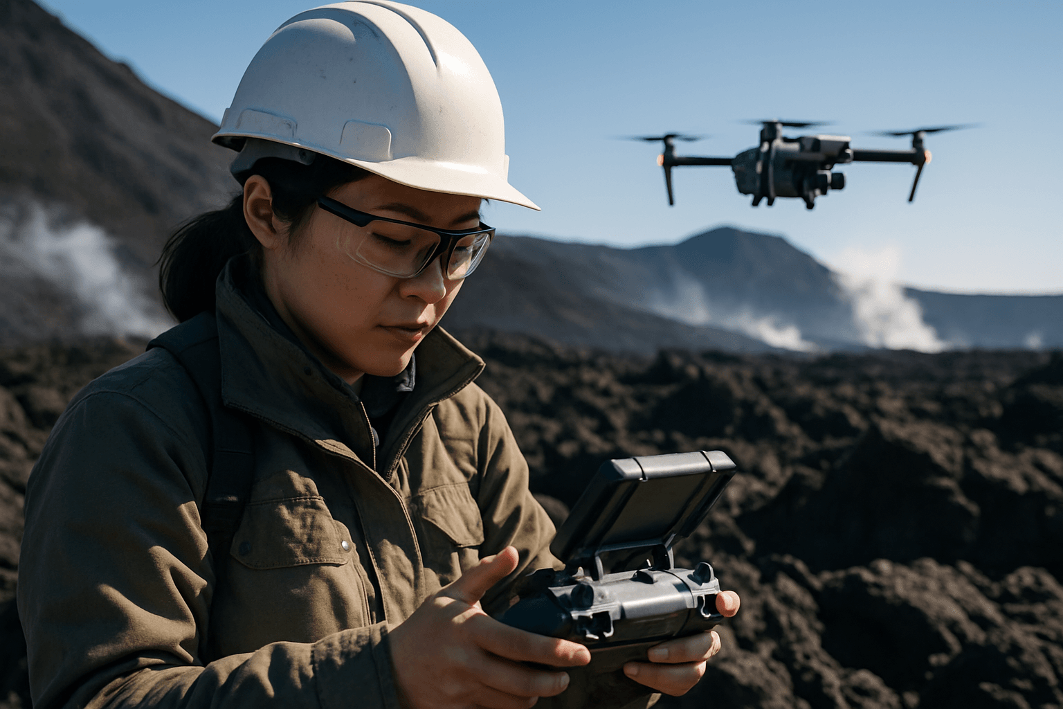
Unmanned Aerial Vehicles (UAVs), commonly known as drones, equipped with advanced cameras and sensors, have emerged as indispensable tools for volcanologists. Their ability to access hazardous and inaccessible areas while keeping human operators at a safe distance is a primary advantage.
Enhanced Safety and Accessibility
Drones drastically reduce the risk to human life. Instead of scientists venturing into dangerous zones, drones can be flown directly over active craters, lava lakes, and gas plumes to collect data. This remote operation capability is particularly vital during eruptions or in areas with unstable ground and deadly gas concentrations. For instance, during the 2021 Cumbre Vieja eruption in La Palma, drones were critical for mapping lava flows and assessing impact without endangering personnel. NASA, in partnership with USGS, has even demonstrated beyond visual line of sight (BVLOS) drone flights to routinely monitor remote volcanoes, a significant step forward for global hazard monitoring.
Unprecedented Resolution and Detail
One of the most significant contributions of drones is the ability to capture high-resolution imagery, far surpassing that of satellite-based remote sensing. These images, when processed using photogrammetry, yield remarkably detailed 2D orthomosaics and 3D models of volcanic landscapes.
The Power of Photogrammetry and Structure-from-Motion (SfM)
Photogrammetry is the science of making precise measurements from photographs. When combined with drones, it involves capturing hundreds of overlapping images of a volcanic area from multiple angles. These images are then fed into specialized software, often employing Structure-from-Motion (SfM) algorithms. SfM techniques identify common points across multiple images, aligning them and computing differences from frame to frame to reconstruct the 3D shape of the terrain.
This process generates several crucial outputs:
- 2D Orthomosaics: Georeferenced, high-resolution aerial maps that accurately represent the ground.
- 3D Point Clouds: Dense collections of 3D data points that define the shape and surface of the volcano.
- Digital Elevation Models (DEMs) / Digital Surface Models (DSMs): Gridded representations of the terrain’s elevation, essential for analyzing topography and volumetric changes.
The resolution achieved can be down to a few centimeters, allowing volcanologists to observe subtle changes that would be invisible in satellite imagery.
Diverse Applications in Volcanic Research and Monitoring
The data gathered through drone-based photogrammetry has a wide array of applications, revolutionizing both fundamental research and practical hazard management.
Mapping Lava Flows and Topographic Changes
Drones are invaluable for mapping active lava flows, precisely delineating their extent and how they reshape the landscape. By comparing successive DEMs from multiple drone flights, scientists can accurately measure lava flow volumes, extrusion rates, and the creation of new land. This capability was vital for the IGN team during the Cumbre Vieja eruption, allowing them to track the 1200-hectare lava flow and assess its impact on infrastructure.
Monitoring Volcanic Structure and Deformation
Regular drone surveys enable the monitoring of changes in a volcano’s morphology, such as the expansion and growth of lava domes or subtle ground deformations that might precede an eruption. High-resolution 3D models can be used to analyze the volcano’s evolution over time, providing a baseline for understanding its behavior. This is crucial for volcanoes with long periods of dormancy, where early detection of shifts is key.
Thermal Imaging and Gas Sampling
Beyond optical cameras, drones can be equipped with thermal imagers to measure surface temperatures, identify heat sources, and detect thermal anomalies that may signal changes in volcanic activity. Some drones also carry gas sensors, allowing scientists to “breathalyse” a volcano by measuring the composition of volcanic gases like sulfur dioxide (SO2) and carbon dioxide (CO2) directly from plumes. Changes in the ratio of these gases can be a critical indicator of an impending eruption.
Pre- and Post-Eruption Assessment
Drones are instrumental both before and after volcanic events. Prior to an eruption, they can provide baseline topographic data and identify potential hazard zones. After an eruption, they quickly assess the scope of damage, identify dangerous areas, and generate post-disaster maps for emergency response and search and rescue operations. This rapid response capability is a stark contrast to traditional methods that might take days or weeks.
Overcoming Challenges and Looking to the Future
Despite the immense advantages, drone operations in volcanic environments present unique challenges. The extreme conditions, including high temperatures, corrosive gases, ash plumes, and unpredictable winds, can lead to the loss or destruction of drones. Regulatory restrictions, such as limitations on beyond visual line of sight (BVLOS) flights, and the difficulty of placing ground control points (GCPs) in hazardous, inaccessible terrain can also complicate data acquisition and georeferencing. Furthermore, skilled operators are required to navigate these complex environments.
However, advancements continue to address these issues. The future of drone-assisted volcano research looks promising, with ongoing developments in:
- AI-driven Navigation: Drones capable of autonomous navigation and obstacle avoidance, including gas plumes.
- Enhanced Sensors: Lighter, more diverse, and resilient sensor payloads that can withstand harsh volcanic conditions and gather even more comprehensive data.
- Coordinated Systems: Fleets of drones working together for more efficient and thorough mapping.
- Improved Processing: Cloud-based photogrammetry platforms are streamlining data processing and sharing for faster results.
The “drone revolution” is poised to bring about major advances in understanding complex physical and chemical volcanic processes, enabling routine monitoring of even the most remote and hazardous volcanoes. By providing a detailed, dynamic picture of volcanic activity, drone-based photogrammetry offers a critical tool for improving eruption forecasts and enhancing community safety worldwide.


