The landscape of modern agriculture is undergoing a profound transformation, driven by innovative technologies that promise unprecedented efficiency and insight. Among these, drone mapping stands out as a game-changer, empowering farmers to monitor, analyze, and optimize their fields with remarkable precision. By leveraging Unmanned Aerial Vehicles (UAVs) equipped with advanced sensors, agricultural drone mapping provides detailed, real-time data that informs critical decision-making, ultimately boosting productivity and promoting sustainable farming practices.
This guide delves into the world of agricultural drone mapping, explaining how these aerial technologies can be harnessed to gain a comprehensive overview of your agricultural landscape, from crop health to soil conditions and resource allocation.
The Transformative Benefits of Drone Mapping in Agriculture
Integrating drones into farming operations offers a multitude of advantages, moving beyond traditional methods to deliver actionable insights and tangible improvements.
Enhanced Crop Monitoring and Health Assessment
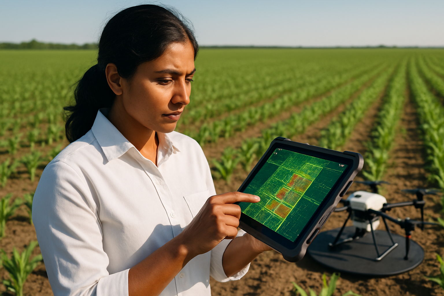
Drones provide an aerial perspective that allows for rapid identification and quantification of damaged or impacted crops. Equipped with specialized cameras, they can detect issues like nutrient deficiencies, pest infestations, and diseases often before they are visible to the naked eye. This early detection enables timely intervention, minimizing crop loss and optimizing treatment plans. Vegetation indices, such as NDVI (Normalized Difference Vegetation Index), generated from drone data, are crucial for assessing plant vigor and health.
Optimized Resource Management and Cost Savings
One of the most significant benefits of drone mapping is its contribution to precision agriculture. Drones help in defining application zones based on crop health analysis, leading to customized prescription maps for fertilizers, growth regulators, and crop protection. This targeted approach drastically reduces the use of herbicides and other inputs, saving costs and minimizing environmental impact. Drones can also provide maps for soil moisture and thermal profiles, guiding precise irrigation and planting decisions, and identifying areas of water stress.
Increased Efficiency and Data Accuracy
Drones can scout vast fields in a fraction of the time it would take on foot, collecting high-resolution data that drives precise decisions and actions. The data collected offers more accurate measurements and higher-quality surveying and mapping outcomes compared to traditional methods. This efficiency not only saves time but also allows for continuous monitoring, tracking crop progression from emergence through harvest, which is invaluable for research and production.
Detailed Field Planning and Analysis
Drone mapping facilitates the creation of detailed 2D and 3D maps, including orthomosaic maps (stitched aerial photos), digital surface models (3D terrain representations), and point clouds. These maps are vital for assessing land area, field boundaries, and topography, aiding in planning irrigation, drainage, and even determining optimal locations for planting.
Essential Drone Technology for Agricultural Mapping
Effective drone mapping relies on specialized hardware and software components working in tandem.
Agricultural Drones (UAVs)
Agricultural drones are designed to be rugged and often offer longer flight times, ideally over 20 minutes. While consumer-grade drones with standard RGB cameras can be used for basic visual scouting, more sophisticated applications require advanced UAVs capable of carrying specialized sensors.
Specialized Sensors for Data Collection
The type of sensor is critical to the data collected and the insights derived.
- RGB Cameras: These are standard visual cameras that capture high-resolution, true-color images (Red, Green, Blue). They are useful for general crop monitoring, pest detection, and assessing visual plant health.
- Multispectral Sensors: These sensors capture data in visible and non-visible wavelengths, including near-infrared (NIR) and red-edge bands. This data is vital for monitoring plant health, biomass, and stress by analyzing chlorophyll levels and plant vigor. Multispectral data helps create vegetation indices like NDVI, which highlight underperforming crop zones.
- Hyperspectral Sensors: Taking spectral imaging to the next level, hyperspectral cameras capture data across hundreds of narrow, continuous spectral bands. This provides more granular, detailed information, allowing for precise analysis of crop health, mineral content, and distinguishing between plant species or identifying hidden diseases and pest outbreaks.
- Thermal Sensors: These cameras detect temperature variations across crop canopies and soil. They are invaluable for revealing water stress, irrigation issues, and transpiration rates, helping optimize water use.
- LiDAR (Light Detection and Ranging) Sensors: LiDAR sensors use laser pulses to measure distances and create detailed 3D maps of the terrain. This technology is particularly helpful for analyzing vegetation structure, planning irrigation and drainage, and understanding true ground surface elevations even under dense canopies.
The Drone Mapping Workflow: From Flight to Insight
Executing an agricultural drone mapping mission involves several systematic steps to ensure accurate data collection and meaningful analysis.
1. Pre-Flight Planning and Preparation
Thorough planning is crucial for a successful mission.
- Weather Conditions: Check weather forecasts for the mapping area, as factors like cloudiness, wind speed, and precipitation significantly impact image quality. Overcast weather is generally acceptable, but avoid major cloud gaps that can cause shadows. The best time for mapping is typically between 10 am and 2 pm when shadows are minimal.
- Area Assessment: Identify the specific field boundaries and any potential no-fly zones. Downloading offline maps of the area can prevent issues with internet connectivity in the field.
- Flight Parameters: Configure drone flight settings based on the crop type and desired image resolution.
- Altitude: Flying at lower altitudes (e.g., 50m/165ft for early-stage crops) provides higher resolution imagery, while higher altitudes cover more ground but result in lower resolution. Ensure compliance with local air regulations.
- Overlap: Sufficient overlap between successive images and passes is critical for accurate image stitching. Recommendations often range from 60-70% sidelap and 70-80% frontlap, depending on the crop and desired resolution.
- Flight Path Planning: Utilize flight planning software to create an autonomous flight path, often a serpentine pattern, to systematically cover the entire field. Many platforms allow for offline flight plan creation.
2. Data Collection (Drone Flight)
Once planned, the drone executes its mission autonomously, capturing a series of overlapping images and sensor measurements over the designated area. The drone will typically return when batteries are low.
3. Data Processing
After the flight, the collected data, often comprising thousands of images, needs to be processed.
- Image Stitching (Photogrammetry): Specialized software stitches the individual images together to create a single, high-resolution orthomosaic map of the entire field. This process requires sufficient image overlap for accurate reconstruction.
- Generating Maps and Models: Beyond orthomosaics, the software generates various outputs:
- Vegetation Index Maps (e.g., NDVI, NDRE): These false-color maps highlight crop health and vigor based on spectral reflectance.
- Digital Surface Models (DSMs): 3D representations of the terrain and crop canopy.
- 3D Terrain Models: Particularly useful for understanding elevation, drainage, and irrigation planning.
4. Analysis and Interpretation
The processed maps and data are then analyzed to derive actionable insights.
- Identifying Stress Zones: Using vegetation indices, farmers can quickly detect stress zones (e.g., yellow or red patches in an NDVI map) that indicate nutrient deficiencies, water stress, or disease outbreaks.
- Precision Application Maps: Data can be used to create variable-rate prescription maps for applying fertilizers, pesticides, or irrigation to specific areas that need it, minimizing waste and maximizing effectiveness.
- Crop Counting and Yield Estimation: High-resolution cameras and algorithms can accurately count plants, track crop emergence, and help predict yield.
- Soil Analysis: Maps can show variations in soil moisture, temperature, and even help assess nutrient levels and plan for optimal seed placement.
Key Software for Agricultural Drone Mapping
A variety of software solutions are available to facilitate flight planning, data processing, and analysis. Many integrate AI-powered analytics to turn drone imagery into actionable insights.
- Pix4Dfields: Known for instant in-field processing, creating accurate maps and models including orthomosaics, vegetation index maps, zonation maps, and prescription maps for spot spraying. It can work offline, making it practical for remote agricultural areas.
- DroneDeploy: An easy-to-use, cloud-based system offering flight planning, plant health analysis, terrain elevation mapping, and data export.
- FieldAgent (Sentera): Dedicated to agricultural applications, providing mobile, web, and desktop applications. It offers NDVI and NDRE zone analysis, population analysis, weed mapping, elevation mapping, and 3D mapping.
- Agremo: This platform integrates with drone imagery to provide AI analyses for crop monitoring, weed detection, stand counts, and nutrient management, generating recipe maps for precision spraying.
- QGIS: A free and open-source Geographic Information System (GIS) software that can be used for georeferencing and further analysis of drone-generated maps.
Regulatory Considerations for Agricultural Drone Operators
Operating drones for commercial agricultural purposes requires adherence to specific regulations, which vary by region.
In the United States, the Federal Aviation Administration (FAA) plays a pivotal role in regulating drone use.
- Remote Pilot Certificate (Part 107): Agricultural drone operators are typically required to obtain a Remote Pilot Certificate (Part 107 certification) to legally operate drones for commercial purposes. This involves passing a knowledge test covering airspace regulations, weather effects, and operational guidelines.
- Drone Registration: Drones weighing 0.55 pounds (250 grams) or more must be registered with the FAA, and the registration number must be visibly marked on the aircraft.
- Part 137 Agricultural Aircraft Operator Certificate: For specific activities like aerial spraying or seeding, operators must obtain an Agricultural Aircraft Operator Certificate under FAA Part 137. This involves an application detailing operations, types of substances applied, and safety protocols, potentially including an on-site inspection.
- State and Local Regulations: Operators must also be aware of and comply with state and local regulations, which may include additional privacy concerns, permitting, or notification requirements.
- EPA Regulations: If using drones for pesticide application, operators must comply with Environmental Protection Agency (EPA) approved pesticide labels and application guidelines, which may require specific certifications.
Conclusion
Drone mapping in agriculture is no longer a futuristic concept but a vital tool for modern farmers. By meticulously planning flights, utilizing appropriate sensors, processing data with specialized software, and adhering to regulatory guidelines, growers can unlock unprecedented levels of insight into their fields. This data-driven approach not only optimizes crop health, enhances yields, and saves costs but also champions sustainable farming practices, ensuring a more productive and resilient agricultural future.


